Randonnée A pied Chédigny - Amboise - J2 G1 - Chédigny et visite du village - Photo

Amboise - J2 G1 - Chédigny et visite du village

Club randonnées SERVON

© OpenStreetMap contributors
Longueur
Longueur
15,9 km
Altitude max
Altitude max
104 m
Dénivelé positif
Dénivelé positif
174 m
Km-Effort
Km-Effort  
18,2 km
Altitude min
Altitude min
61 m
Dénivelé négatif
Dénivelé négatif
174 m
Boucle
Boucle
Oui
Date de création :
2022-11-07 11:05:28.252
Dernière modification :
2023-05-10 15:39:13.028

(0 Avis)

A pied
A pied
4h08
Difficulté : Facile

Scannez ce code QR pour ouvrir la randonnée dans l'application SityTrail

Application GPS de randonnée GRATUITE

Logo SityTrail SityTrail

IGN / Instituts géographiques

Télécharger SityTrail sur l'App Store Télécharger SityTrail sur Google Play

Logo SityTrail SityTrail World

Le monde est à vous

Télécharger SityTrail sur l'App Store Télécharger SityTrail sur Google Play Télécharger SityTrail sur Huawei AppGallery

À propos

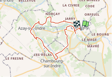
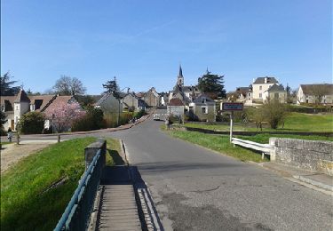
Randonnée A pied de 15,9 km à découvrir à Centre-Val de Loire, Indre-et-Loire, Chédigny. Cette randonnée est proposée par Les 1000 pattes.

Description

Parking cimetière communal de Chédigny sur D10
Pouvant être raccourcie au lieu-dit le Grand Chêne direction Morillon

Profil altimétrique

Points d'intérêt

Point d'intérêt Chédigny - Chédigny - Photo
cramcl50
CHÉDIGNY 
Point d'intérêt Chédigny - le hameau de la Rochette - Photo
cramcl50
Point d'intérêt Azay-sur-Indre - le château de la Follaine - Photo
cramcl50
Point d'intérêt Azay-sur-Indre - le moulin de la Follaine - Photo
cramcl50
AZAY-SUR-INDRE 
Point d'intérêt Azay-sur-Indre - l'Indrois - Photo
cramcl50
AZAY-SUR-INDRE 
Point d'intérêt Azay-sur-Indre - Pique nique - Photo
cramcl50
AZAY-SUR-INDRE 
Point d'intérêt Chédigny - l'éolienne  Bollée - Photo
cramcl50

Localisation

Pays :
France
Région :
Centre-Val de Loire
Département/Province :
Indre-et-Loire
Commune :
Chédigny
Localité :
Unknown
Départ:(UTM)
348604 ; 5230123 (31T) N.

Randonnées à proximité

Randonnée Marche Chédigny - Chedigny 9km - Photo
Marche
MichelRando7656

Marche

Moyen
Chédigny, Centre-Val de Loire, Indre-et-Loire, France
10,9 km | 12,3 km-effort
3h 13min
Oui
Randonnée A pied Chédigny - Circuit Chédigny - Photo
A pied
PRO

A pied

Facile
Chédigny, Centre-Val de Loire, Indre-et-Loire, France
12,8 km | 14,7 km-effort
3h 20min
Oui
Randonnée A pied Chambourg-sur-Indre - Entre Indre et Indrois - Photo
A pied
PRO

A pied

Facile
Chambourg-sur-Indre, Centre-Val de Loire, Indre-et-Loire, France
10,4 km | 12,1 km-effort
2h 45min
Oui
Randonnée Marche Chambourg-sur-Indre - Chambourg-sur-Indre - l'Isle Auger Loches GR46 - 26.7km 325m 5h40 (30mn) - 2021 07 24 - Photo
Marche
Orcal37

Marche

Facile
Chambourg-sur-Indre, Centre-Val de Loire, Indre-et-Loire, France
27 km | 31 km-effort
5h 40min
Oui
Randonnée Marche Azay-sur-Indre - Azay-sur-Indre - GR46 PR Chambourg-sur-Indre - 18.2km 200m 2h55 (23mn) - 2021 03 06 - Photo
Marche
Orcal37

Marche

Facile
Azay-sur-Indre, Centre-Val de Loire, Indre-et-Loire, France
18,2 km | 21 km-effort
3h 55min
Oui
Randonnée Marche Chédigny - Chédigny - Photo
Marche
fustier

Marche

Très difficile
(1)
Chédigny, Centre-Val de Loire, Indre-et-Loire, France
19,5 km | 22 km-effort
4h 53min
Oui
Randonnée Marche Chambourg-sur-Indre - Chambourg-sur-Indre - Photo
Marche
LEMENIO

Marche

Moyen
Chambourg-sur-Indre, Centre-Val de Loire, Indre-et-Loire, France
13,4 km | 15,3 km-effort
3h 20min
Non
Randonnée Marche Chédigny - 10K-Chedigny - Photo
Marche
Robert62

Marche

Très facile
Chédigny, Centre-Val de Loire, Indre-et-Loire, France
10,4 km | 11,8 km-effort
3h 20min
Oui
Randonnée V.T.C. Saint-Quentin-sur-Indrois - vallée de l'Indrois Montresor chedigny - Photo
V.T.C.
jeanjean37

V.T.C.

Moyen
Saint-Quentin-sur-Indrois, Centre-Val de Loire, Indre-et-Loire, France
55 km | 64 km-effort
3h 36min
Oui


Fermer
Mes abonnements