![](/images/other/stat-length.png)
![Randonnée Marche Bazeilles - Du milieu de la forêt à Carignon - Photo](https://media.geolcdn.com/t/1900/400/ext.pjpeg?maxdim=2&url=https%3A%2F%2Fmedia.geolcdn.com%2Ff%2Fab0a3f6b-d701-4e49-bb57-67a9d1c80290.jpg)
Du milieu de la forêt à Carignon
jeff2
Utilisateur
![Longueur](/images/other/stat-length.png)
Longueur
34 km
![Altitude max](https://static1.geolcdn.com/siteimages/upload/files/1508320355ic_sort_altitude_max_24dp.png)
Altitude max
438 m
![Dénivelé positif](https://static1.geolcdn.com/siteimages/upload/files/1508320355ic_sort_den_pos_24dp.png)
Dénivelé positif
343 m
![Km-Effort](/images/other/stat-length.png)
Km-Effort
39 km
![Altitude min](https://static1.geolcdn.com/siteimages/upload/files/1508320355ic_sort_altitude_min_24dp.png)
Altitude min
160 m
![Dénivelé négatif](https://static1.geolcdn.com/siteimages/upload/files/1508320355ic_sort_den_neg_24dp.png)
Dénivelé négatif
566 m
![Boucle](https://static1.geolcdn.com/siteimages/upload/files/16400158638029165_repeat_loop_refresh_sync_direction_icon.png)
Boucle
Non
Date de création :
2023-05-16 04:11:28.222
Dernière modification :
2023-05-16 15:41:07.503
![Marche](https://static1.geolcdn.com/sitytour/trail-icons/101.png)
7h53
Difficulté : Moyen
![Scannez ce code QR pour ouvrir la randonnée dans l'application SityTrail](https://capi.geolives.com/qq0zvz2zws4bq2lad0pu/sitytour/trails/3661834/qr.png?size=200)
Application GPS de randonnée GRATUITE
À propos
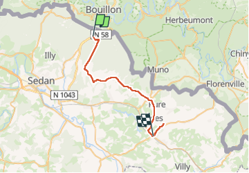
Randonnée Marche de 34 km à découvrir à Grand Est, Ardennes, Bazeilles. Cette randonnée est proposée par jeff2.
Description
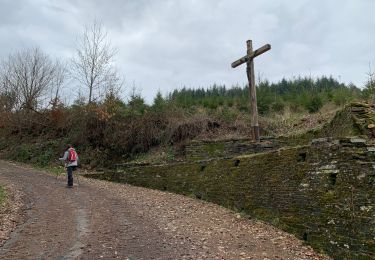
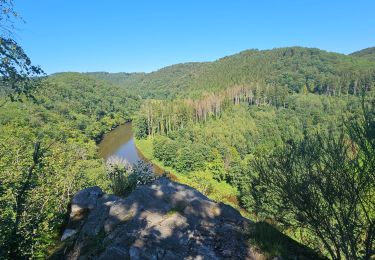
Départ dans une forêt magnifique, ligne droite de 4kms, au milieu des chênes. Puis tranquille ballade de village en village et arrivée à Carignon, la Mairie nous prête une maison entière.!!! Enfin de l'eau de la place au sec, presque le bonheur...
Localisation
Pays :
France
Région :
Grand Est
Département/Province :
Ardennes
Commune :
Bazeilles
Localité :
Villers-Cernay
Départ:(Dec)
Départ:(UTM)
647492 ; 5513942 (31U) N.
Commentaires
Randonnées à proximité
![Randonnée Marche Bouillon - RB-Lu-13_Bouillon - Photo](https://media.geolcdn.com/t/375/260/ext.jpg?maxdim=2&url=https%3A%2F%2Fservices.sitytrail.com%2FGeolivesWS%2FDownloadMedia.ashx%3FTrailID%3D179618%26Media%3Dc93ae6e1-6a5c-490e-ab2b-3f360dd3a9f8.jpg)
![Marche Marche](https://static1.geolcdn.com/sitytour/trail-icons/101.png)
RB-Lu-13_Bouillon
Marche
Moyen
(8)
Bouillon,
Wallonie,
Luxembourg,
Belgique
![](/images/other/stat-length.png)
20 km | 30 km-effort
5h 55min
![](https://static1.geolcdn.com/siteimages/upload/files/16400158638029165_repeat_loop_refresh_sync_direction_icon.png)
Oui
![Randonnée Marche Bouillon - RB-Lu-13_Bouillon_via-racc - Photo](https://media.geolcdn.com/t/375/260/ext.jpg?maxdim=2&url=https%3A%2F%2Fservices.sitytrail.com%2FGeolivesWS%2FDownloadMedia.ashx%3FTrailID%3D216805%26Media%3Dc93ae6e1-6a5c-490e-ab2b-3f360dd3a9f8.jpg)
![Marche Marche](https://static1.geolcdn.com/sitytour/trail-icons/101.png)
RB-Lu-13_Bouillon_via-racc
Marche
Moyen
(4)
Bouillon,
Wallonie,
Luxembourg,
Belgique
![](/images/other/stat-length.png)
16,7 km | 25 km-effort
4h 54min
![](https://static1.geolcdn.com/siteimages/upload/files/16400158638029165_repeat_loop_refresh_sync_direction_icon.png)
Oui
![Randonnée Marche Bouillon - De Corbion à la Roche aux Eperviers - Photo](https://media.geolcdn.com/t/375/260/ext.jpg?maxdim=2&url=https%3A%2F%2Fservices.sitytrail.com%2FGeolivesWS%2FDownloadMedia.ashx%3FTrailID%3D146950%26Media%3D6d765926-55f0-4539-a611-ffe05c9bf6d8.JPG)
![Marche Marche](https://static1.geolcdn.com/sitytour/trail-icons/101.png)
De Corbion à la Roche aux Eperviers
Marche
Facile
(1)
Bouillon,
Wallonie,
Luxembourg,
Belgique
![](/images/other/stat-length.png)
10,6 km | 14,6 km-effort
2h 50min
![](https://static1.geolcdn.com/siteimages/upload/files/16400158638029165_repeat_loop_refresh_sync_direction_icon.png)
Oui
![Randonnée Marche Bouillon - De Corbion à Poupehan par la Roche des Fées et la Chaire à Prêcher - Photo](https://media.geolcdn.com/t/375/260/ext.jpg?maxdim=2&url=https%3A%2F%2Fservices.sitytrail.com%2FGeolivesWS%2FDownloadMedia.ashx%3FTrailID%3D138476%26Media%3D05b27b25-8086-41d3-96c5-76c508b6a7d7.JPG)
![Marche Marche](https://static1.geolcdn.com/sitytour/trail-icons/101.png)
De Corbion à Poupehan par la Roche des Fées et la Chaire à Prêcher
Marche
Moyen
(2)
Bouillon,
Wallonie,
Luxembourg,
Belgique
![](/images/other/stat-length.png)
7,3 km | 11,1 km-effort
3h 0min
![](https://static1.geolcdn.com/siteimages/upload/files/16400158638029165_repeat_loop_refresh_sync_direction_icon.png)
Oui
![Randonnée Marche Bouillon - Corbion - Le Sentier des Points de Vue - Photo](https://media.geolcdn.com/t/375/260/ext.jpg?maxdim=2&url=https%3A%2F%2Fservices.sitytrail.com%2FGeolivesWS%2FDownloadMedia.ashx%3FTrailID%3D138106%26Media%3D530b3448-4c03-4266-ae4e-a2076c332785.JPG)
![Marche Marche](https://static1.geolcdn.com/sitytour/trail-icons/101.png)
Corbion - Le Sentier des Points de Vue
Marche
Moyen
(7)
Bouillon,
Wallonie,
Luxembourg,
Belgique
![](/images/other/stat-length.png)
8,6 km | 12,2 km-effort
3h 0min
![](https://static1.geolcdn.com/siteimages/upload/files/16400158638029165_repeat_loop_refresh_sync_direction_icon.png)
Oui
![Randonnée Marche Bouillon - Promenade vers la Passerelle de l’épine - Photo](https://media.geolcdn.com/t/375/260/ext.jpg?maxdim=2&url=https%3A%2F%2Fmedia.geolcdn.com%2Ff%2Fa030b44f-54a7-48fb-92fc-a78ebfcb2520.jpg)
![Marche Marche](https://static1.geolcdn.com/sitytour/trail-icons/101.png)
Promenade vers la Passerelle de l’épine
Marche
Moyen
(6)
Bouillon,
Wallonie,
Luxembourg,
Belgique
![](/images/other/stat-length.png)
7,3 km | 11,2 km-effort
2h 33min
![](https://static1.geolcdn.com/siteimages/upload/files/16400158638029165_repeat_loop_refresh_sync_direction_icon.png)
Oui
![Randonnée Marche Bouillon - Noordelijke bossen Bouillon 15 km - Photo](https://media.geolcdn.com/t/375/260/ext.jpg?maxdim=2&url=https%3A%2F%2Fmedia.geolcdn.com%2Ff%2F0e7e8d04-0083-4c73-a21c-9fb131f85eaa.jpg)
![Marche Marche](https://static1.geolcdn.com/sitytour/trail-icons/101.png)
Noordelijke bossen Bouillon 15 km
Marche
Très difficile
(1)
Bouillon,
Wallonie,
Luxembourg,
Belgique
![](/images/other/stat-length.png)
16,2 km | 24 km-effort
3h 43min
![](https://static1.geolcdn.com/siteimages/upload/files/16400158638029165_repeat_loop_refresh_sync_direction_icon.png)
Oui
![Randonnée Marche Bouillon - De Bouillon vers Corbion par le Tombeau du Geant - Photo](https://media.geolcdn.com/t/375/260/ext.jpg?maxdim=2&url=https%3A%2F%2Fstatic1.geolcdn.com%2Fsiteimages%2Fupload%2Ffiles%2F1553511878bg_sport_marche.png)
![Marche Marche](https://static1.geolcdn.com/sitytour/trail-icons/101.png)
De Bouillon vers Corbion par le Tombeau du Geant
Marche
Difficile
(5)
Bouillon,
Wallonie,
Luxembourg,
Belgique
![](/images/other/stat-length.png)
20 km | 30 km-effort
5h 0min
![](https://static1.geolcdn.com/siteimages/upload/files/16400158638029165_repeat_loop_refresh_sync_direction_icon.png)
Oui
![Randonnée Marche Bouillon - Le Sentier des Points de Vues - Bouillon - Photo](https://media.geolcdn.com/t/375/260/ext.jpg?maxdim=2&url=https%3A%2F%2Fmedia.geolcdn.com%2Ff%2Fd6b9feb0-c584-4b07-ac76-bf827e5d1680.jpg)
![Marche Marche](https://static1.geolcdn.com/sitytour/trail-icons/101.png)
Le Sentier des Points de Vues - Bouillon
Marche
Difficile
Bouillon,
Wallonie,
Luxembourg,
Belgique
![](/images/other/stat-length.png)
8,5 km | 12,2 km-effort
2h 47min
![](https://static1.geolcdn.com/siteimages/upload/files/16400158638029165_repeat_loop_refresh_sync_direction_icon.png)
Oui