Trail Walking Bazeilles - Du milieu de la forêt à Carignon - Photo

Du milieu de la forêt à Carignon

 jeff2
jeff2

User

© OpenStreetMap contributors
Length
Length
34 km
Max alt
Max alt
438 m
Uphill gradient
Uphill gradient
343 m
Km-Effort
Km-Effort  
39 km
Min alt
Min alt
160 m
Downhill gradient
Downhill gradient
566 m
Boucle
Boucle
No
Creation date :
2023-05-16 04:11:28.222
Updated on :
2023-05-16 15:41:07.503

(0 Reviews)

Walking
Walking
7h53
Difficulty : Medium

Scan this QR Code to open this trail in the SityTrail application

FREE GPS app for hiking

Logo SityTrail SityTrail

IGN / Geographical institutes

Download SityTrail from the App Store Download SityTrail from Google Play

Logo SityTrail SityTrail World

The world is yours!

Download SityTrail from the App Store Download SityTrail from Google Play Download SityTrail on Huawei AppGallery

About

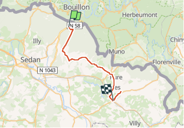
Trail Walking of 34 km to be discovered at Grand Est, Ardennes, Bazeilles. This trail is proposed by jeff2.

Description

Départ dans une forêt magnifique, ligne droite de 4kms, au milieu des chênes. Puis tranquille ballade de village en village et arrivée à Carignon, la Mairie nous prête une maison entière.!!! Enfin de l'eau de la place au sec, presque le bonheur...

Elevation profile

Photos

Positioning

Country:
France
Region :
Grand Est
Department/Province :
Ardennes
Municipality :
Bazeilles
Location:
Villers-Cernay
Start:(UTM)
647492 ; 5513942 (31U) N.

Trails nearby

Trail Walking Bouillon - RB-LUX-13 - Les belvédères bouillonnais - Photo
Walking
PRO

Walking

Medium
(8)
Bouillon, Wallonia, Luxembourg, Belgium
20 km | 30 km-effort
5h 55min
Yes
Trail Walking Bouillon - RB-LUX-13 - Raccourci - Les belvédères bouillonnais - Photo
Walking
PRO

Walking

Medium
(4)
Bouillon, Wallonia, Luxembourg, Belgium
16.7 km | 25 km-effort
4h 54min
Yes
Trail Walking Bouillon - De Corbion à la Roche aux Eperviers - Photo
Walking
GUIDE
Desrumaux

Walking

Easy
(1)
Bouillon, Wallonia, Luxembourg, Belgium
10.6 km | 14.6 km-effort
2h 50min
Yes
Trail Walking Bouillon - De Corbion à Poupehan par la Roche des Fées et la Chaire à Prêcher - Photo
Walking
GUIDE
Desrumaux

Walking

Medium
(2)
Bouillon, Wallonia, Luxembourg, Belgium
7.3 km | 11.1 km-effort
3h 0min
Yes
Trail Walking Bouillon - Corbion - Le Sentier des Points de Vue - Photo
Walking
GUIDE
Desrumaux

Walking

Medium
(7)
Bouillon, Wallonia, Luxembourg, Belgium
8.6 km | 12.2 km-effort
3h 0min
Yes
Trail Walking Bouillon - Promenade vers la Passerelle de l’épine  - Photo
Walking
GUIDE+

Walking

Medium
(6)
Bouillon, Wallonia, Luxembourg, Belgium
7.3 km | 11.2 km-effort
2h 33min
Yes
Trail Walking Bouillon - Noordelijke bossen Bouillon 15 km - Photo
Walking
mavbelgium

Walking

Very difficult
(1)
Bouillon, Wallonia, Luxembourg, Belgium
16.2 km | 24 km-effort
3h 43min
Yes
Trail Walking Bouillon - De Bouillon vers Corbion par le Tombeau du Geant - Photo
Walking
GUIDE
Desrumaux

Walking

Difficult
(5)
Bouillon, Wallonia, Luxembourg, Belgium
20 km | 30 km-effort
5h 0min
Yes
Trail Walking Bouillon - Le Sentier des Points de Vues - Bouillon - Photo
Walking
GUIDE
Desrumaux

Walking

Difficult
Bouillon, Wallonia, Luxembourg, Belgium
8.5 km | 12.2 km-effort
2h 47min
Yes


Close
My subscriptions