


whitwick woods

kingjim1977
Utilisateur
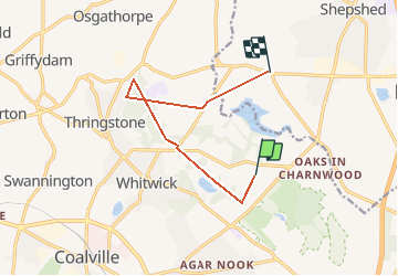

Longueur
7,9 km

Altitude max
211 m

Dénivelé positif
137 m
Km-Effort
10 km

Altitude min
91 m

Dénivelé négatif
220 m
Boucle
Non
Date de création :
2014-12-10 00:00:00.0
Dernière modification :
2014-12-10 00:00:00.0
--
Difficulté : Inconnu

Application GPS de randonnée GRATUITE
 SityTrail
IGN / Instituts géographiques
SityTrail World
Le monde est à vous
À propos
Randonnée V.T.T. de 7,9 km à découvrir à Angleterre, Leicestershire, North West Leicestershire. Cette randonnée est proposée par kingjim1977.
Localisation
Pays :
Royaume-Uni
Région :
Angleterre
Département/Province :
Leicestershire
Commune :
North West Leicestershire
Localité :
Unknown
Départ:(Dec)
Départ:(UTM)
613313 ; 5844811 (30U) N.
Commentaires
Randonnées à proximité