


whitwick woods

kingjim1977
Gebruiker
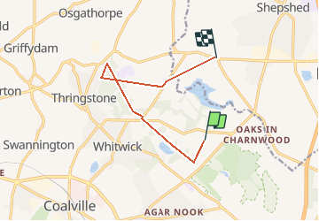

Lengte
7,9 km

Max. hoogte
211 m

Positief hoogteverschil
137 m
Km-Effort
10 km

Min. hoogte
91 m

Negatief hoogteverschil
220 m
Boucle
Neen
Datum van aanmaak :
2014-12-10 00:00:00.0
Laatste wijziging :
2014-12-10 00:00:00.0
--
Moeilijkheid : Onbekend

Gratisgps-wandelapplicatie
 SityTrail
IGN / Geografische instituten
SityTrail World
De wereld gaat voor u open
Over ons
Tocht Mountainbike van 7,9 km beschikbaar op Engeland, Leicestershire, North West Leicestershire. Deze tocht wordt voorgesteld door kingjim1977.
Plaatsbepaling
Land:
United Kingdom
Regio :
Engeland
Departement/Provincie :
Leicestershire
Gemeente :
North West Leicestershire
Locatie:
Unknown
Vertrek:(Dec)
Vertrek:(UTM)
613313 ; 5844811 (30U) N.
Opmerkingen
Wandeltochten in de omgeving