Randonnée V.T.C. Mercuès - Voie verte Mercues - Photo

Voie verte Mercues

 antignacs
antignacs

Utilisateur GUIDE

© OpenStreetMap contributors
Longueur
Longueur
10,9 km
Altitude max
Altitude max
157 m
Dénivelé positif
Dénivelé positif
133 m
Km-Effort
Km-Effort  
12,7 km
Altitude min
Altitude min
104 m
Dénivelé négatif
Dénivelé négatif
135 m
Boucle
Boucle
Oui
Date de création :
2023-08-22 06:08:54.0
Dernière modification :
2023-08-27 16:39:17.058

(0 Avis)

V.T.C.
V.T.C.
1h57
Difficulté : Très facile

Scannez ce code QR pour ouvrir la randonnée dans l'application SityTrail

Application GPS de randonnée GRATUITE

Logo SityTrail SityTrail

IGN / Instituts géographiques

Télécharger SityTrail sur l'App Store Télécharger SityTrail sur Google Play

Logo SityTrail SityTrail World

Le monde est à vous

Télécharger SityTrail sur l'App Store Télécharger SityTrail sur Google Play Télécharger SityTrail sur Huawei AppGallery

À propos

Randonnée V.T.C. de 10,9 km à découvrir à Occitanie, Lot, Mercuès. Cette randonnée est proposée par antignacs.

Profil altimétrique

Photos

Localisation

Pays :
France
Région :
Occitanie
Département/Province :
Lot
Commune :
Mercuès
Localité :
Unknown
Départ:(Dec)
Départ:(UTM)
371346 ; 4927871 (31T) N.

Randonnées à proximité

Randonnée Marche nordique Pradines - 15km chemin des combettes - Photo
Marche nordique
Dominique Molinier

Marche nordique

Très facile
(1)
Pradines, Occitanie, Lot, France
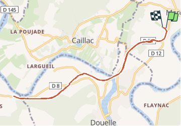
14,8 km | 17,9 km-effort
2h 15min
Oui
Randonnée Marche Crayssac - Crayssac Cévennes  - Photo
Marche
GUIDE
antignacs

Marche

Très facile
Crayssac, Occitanie, Lot, France
6,3 km | 9,1 km-effort
1h 43min
Non
Randonnée Marche Cahors - Étape Cahors Lascabannes  - Photo
Marche
Jean-MarieFaux

Marche

Facile
Cahors, Occitanie, Lot, France
23 km | 30 km-effort
18h 50min
Non
Randonnée Marche Calamane - Calamane  - Photo
Marche
GUIDE
antignacs

Marche

Très facile
Calamane, Occitanie, Lot, France
12 km | 15,1 km-effort
2h 36min
Oui
Randonnée Marche Mercuès - Mercues Caillac  - Photo
Marche
GUIDE
antignacs

Marche

Très facile
Mercuès, Occitanie, Lot, France
8,1 km | 9,7 km-effort
1h 59min
Oui
Randonnée Marche Cahors -  cahors lascabanne durand - Photo
Marche
fab0202

Marche

Moyen
Cahors, Occitanie, Lot, France
24 km | 30 km-effort
6h 32min
Non
Randonnée Marche Mercuès - Mercues Caillac  - Photo
Marche
GUIDE
antignacs

Marche

Très facile
Mercuès, Occitanie, Lot, France
10,4 km | 12,4 km-effort
2h 8min
Oui
Randonnée Marche Pradines - Pradines  - Photo
Marche
GUIDE
antignacs

Marche

Très facile
Pradines, Occitanie, Lot, France
6,2 km | 6,8 km-effort
1h 27min
Oui
Randonnée Marche Mercuès - Château les bouysses  - Photo
Marche
GUIDE
antignacs

Marche

Très facile
Mercuès, Occitanie, Lot, France
3,5 km | 4,2 km-effort
52min
Oui


Fermer
Mes abonnements