Randonnée Marche Lacroix-Barrez - Vallon, les gorges de la Thruyère - Photo

Vallon, les gorges de la Thruyère

 jocelyneviel
jocelyneviel

Utilisateur

© OpenStreetMap contributors
Longueur
Longueur
8,3 km
Altitude max
Altitude max
767 m
Dénivelé positif
Dénivelé positif
378 m
Km-Effort
Km-Effort  
13,3 km
Altitude min
Altitude min
417 m
Dénivelé négatif
Dénivelé négatif
372 m
Boucle
Boucle
Oui
Date de création :
2023-09-06 06:22:33.894
Dernière modification :
2023-09-06 09:27:05.286

(0 Avis)

Marche
Marche
2h41
Difficulté : Moyen

Scannez ce code QR pour ouvrir la randonnée dans l'application SityTrail

Application GPS de randonnée GRATUITE

Logo SityTrail SityTrail

IGN / Instituts géographiques

Télécharger SityTrail sur l'App Store Télécharger SityTrail sur Google Play

Logo SityTrail SityTrail World

Le monde est à vous

Télécharger SityTrail sur l'App Store Télécharger SityTrail sur Google Play Télécharger SityTrail sur Huawei AppGallery

À propos

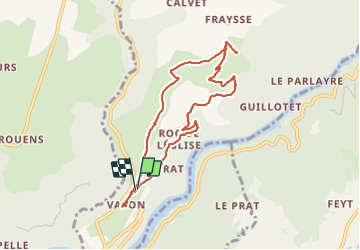
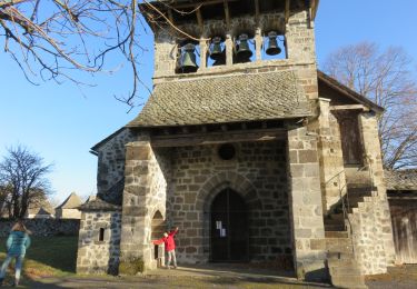
Randonnée Marche de 8,3 km à découvrir à Occitanie, Aveyron, Lacroix-Barrez. Cette randonnée est proposée par jocelyneviel.

Description

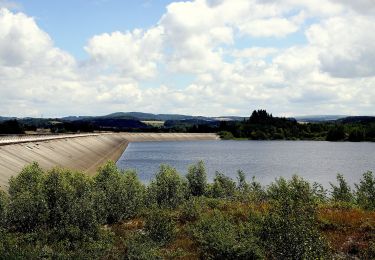
eau panorama au dessus des gorges de la Thruyère.

Profil altimétrique

Localisation

Pays :
France
Région :
Occitanie
Département/Province :
Aveyron
Commune :
Lacroix-Barrez
Localité :
Unknown
Départ:(Dec)
Départ:(UTM)
471195 ; 4954165 (31T) N.

Randonnées à proximité

Randonnée A pied Montézic - Saut du Chien - Photo
A pied
PRO

A pied

Facile
Montézic, Occitanie, Aveyron, France
4,2 km | 5,8 km-effort
1h 18min
Non
Randonnée Marche Lacroix-Barrez - Chateau Vallon au depart de Bars  - Photo
Marche
tercla

Marche

Moyen
Lacroix-Barrez, Occitanie, Aveyron, France
19,2 km | 27 km-effort
6h 31min
Oui
Randonnée Marche Lacroix-Barrez - a effacer - Photo
Marche
avdem

Marche

Facile
Lacroix-Barrez, Occitanie, Aveyron, France
1,8 km | 2,3 km-effort
40min
Non
Randonnée Marche Lacroix-Barrez - Boucle Bars, château de Vallon, Fraysse  - Photo
Marche
destras

Marche

Moyen
(1)
Lacroix-Barrez, Occitanie, Aveyron, France
18,6 km | 27 km-effort
4h 58min
Oui
Randonnée Marche Saint-Symphorien-de-Thénières - 12_saint_gervais_valon_dilhac_2024 - Photo
Marche
jab31

Marche

Très difficile
Saint-Symphorien-de-Thénières, Occitanie, Aveyron, France
17,3 km | 25 km-effort
5h 41min
Non
Randonnée Marche Saint-Symphorien-de-Thénières - 12_saint-gervais_valon_2024 - Photo
Marche
jab31

Marche

Très difficile
Saint-Symphorien-de-Thénières, Occitanie, Aveyron, France
19,3 km | 29 km-effort
6h 41min
Non
Randonnée Marche Lacroix-Barrez - 12_valon_ginolhac_2024 - Photo
Marche
jab31

Marche

Très difficile
Lacroix-Barrez, Occitanie, Aveyron, France
21 km | 34 km-effort
7h 39min
Non
Randonnée Marche Saint-Hippolyte - La_retenue_de_Couesques - Photo
Marche
neoroll44

Marche

Très difficile
Saint-Hippolyte, Occitanie, Aveyron, France
13,7 km | 20 km-effort
4h 35min
Oui
Randonnée Autre activité Murols - Les Bois de Murols - Photo
Autre activité
Lacaze

Autre activité

Difficile
Murols, Occitanie, Aveyron, France
9,2 km | 15 km-effort
5min
Oui


Fermer
Mes abonnements