Randonnée Marche Obernai - Obernai-150621 - VVF-ParcoursEhn - Photo

Obernai-150621 - VVF-ParcoursEhn

 randodan
randodan

Utilisateur

© OpenStreetMap contributors
Longueur
Longueur
6,9 km
Altitude max
Altitude max
257 m
Dénivelé positif
Dénivelé positif
88 m
Km-Effort
Km-Effort  
8 km
Altitude min
Altitude min
196 m
Dénivelé négatif
Dénivelé négatif
86 m
Boucle
Boucle
Oui
Date de création :
2015-06-23 00:00:00.0
Dernière modification :
2015-06-23 00:00:00.0

(0 Avis)

Marche
Marche
1h50
Difficulté : Très facile

Scannez ce code QR pour ouvrir la randonnée dans l'application SityTrail

Application GPS de randonnée GRATUITE

Logo SityTrail SityTrail

IGN / Instituts géographiques

Télécharger SityTrail sur l'App Store Télécharger SityTrail sur Google Play

Logo SityTrail SityTrail World

Le monde est à vous

Télécharger SityTrail sur l'App Store Télécharger SityTrail sur Google Play Télécharger SityTrail sur Huawei AppGallery

À propos

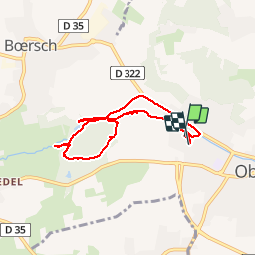
Randonnée Marche de 6,9 km à découvrir à Grand Est, Bas-Rhin, Obernai. Cette randonnée est proposée par randodan.

Description

Obernais, 21 juin 2015<br>
- Parcours de l'Ehn -<br>
(d'après le Guide Obernai 2013)<br>
9h, départ du VVF.<br>
Zut, après les étangs de pêche, je fais prendre par erreur la route d'Ottrott, demi-tour . Et bien sûr je me fais charrier ! Les 2 fois suivantes, c'est la carte IGN qui mentionne des sentiers qui n'existent pas/plus . Bref j'en serai pour une tournée d'apéro à l'arrivée.<br>
10h50, de retour au logement.<br>
6 participants (Jo,Ca,Ja,Chan,Mi,Da)

Profil altimétrique

Photos

Points d'intérêt

Localisation

Pays :
France
Région :
Grand Est
Département/Province :
Bas-Rhin
Commune :
Obernai
Localité :
Unknown
Départ:(Dec)
Départ:(UTM)
386739 ; 5369262 (32U) N.

Randonnées à proximité

Randonnée Marche Ottrott - Le circuit sud du Mur Païen - Photo
Marche
VacheKiri67

Marche

Facile
(2)
Ottrott, Grand Est, Bas-Rhin, France
4,9 km | 6,3 km-effort
1h 56min
Non
Randonnée Marche Ottrott - Le circuit nord du Mur Païen - Photo
Marche
VacheKiri67

Marche

Facile
(1)
Ottrott, Grand Est, Bas-Rhin, France
5,9 km | 8,5 km-effort
2h 4min
Non
Randonnée Marche Ottrott - Le Mont Sainte-Odile depuis Otrott - Photo
Marche
VacheKiri67

Marche

Moyen
(1)
Ottrott, Grand Est, Bas-Rhin, France
13 km | 20 km-effort
6h 18min
Oui
Randonnée Marche Ottrott - Mur Paien complet - Photo
Marche
markrei

Marche

Moyen
(1)
Ottrott, Grand Est, Bas-Rhin, France
12 km | 16,4 km-effort
5h 25min
Oui
Randonnée Marche Obernai - Obernai gare - Mont St Odile - Photo
Marche
tracegps

Marche

Difficile
(2)
Obernai, Grand Est, Bas-Rhin, France
20 km | 29 km-effort
5h 0min
Oui
Randonnée V.T.T. Barr - Circuit des 3 Petits Ponts - Photo
V.T.T.
tracegps

V.T.T.

Difficile
(1)
Barr, Grand Est, Bas-Rhin, France
15,9 km | 22 km-effort
1h 19min
Oui
Randonnée V.T.T. Ottrott - Sainte-Odile East-Face - Photo
V.T.T.
tracegps

V.T.T.

Difficile
(1)
Ottrott, Grand Est, Bas-Rhin, France
24 km | 39 km-effort
3h 0min
Oui
Randonnée A pied Rosheim - Circuit du Vignoble - Photo
A pied
PRO

A pied

Facile
Rosheim, Grand Est, Bas-Rhin, France
8,8 km | 11,7 km-effort
2h 38min
Oui
Randonnée A pied Bischoffsheim - Circuit des Balcons - Photo
A pied
PRO

A pied

Facile
(1)
Bischoffsheim, Grand Est, Bas-Rhin, France
12,4 km | 15,4 km-effort
3h 30min
Oui


Fermer
Mes abonnements