Trail Walking Obernai - Obernai-150621 - VVF-ParcoursEhn - Photo

Obernai-150621 - VVF-ParcoursEhn

 randodan
randodan

User

© OpenStreetMap contributors
Length
Length
6.9 km
Max alt
Max alt
257 m
Uphill gradient
Uphill gradient
88 m
Km-Effort
Km-Effort  
8 km
Min alt
Min alt
196 m
Downhill gradient
Downhill gradient
86 m
Boucle
Boucle
Yes
Creation date :
2015-06-23 00:00:00.0
Updated on :
2015-06-23 00:00:00.0

(0 Reviews)

Walking
Walking
1h50
Difficulty : Very easy

Scan this QR Code to open this trail in the SityTrail application

FREE GPS app for hiking

Logo SityTrail SityTrail

IGN / Geographical institutes

Download SityTrail from the App Store Download SityTrail from Google Play

Logo SityTrail SityTrail World

The world is yours!

Download SityTrail from the App Store Download SityTrail from Google Play Download SityTrail on Huawei AppGallery

About

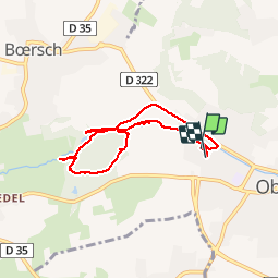
Trail Walking of 6.9 km to be discovered at Grand Est, Bas-Rhin, Obernai. This trail is proposed by randodan.

Description

Obernais, 21 juin 2015<br>
- Parcours de l'Ehn -<br>
(d'après le Guide Obernai 2013)<br>
9h, départ du VVF.<br>
Zut, après les étangs de pêche, je fais prendre par erreur la route d'Ottrott, demi-tour . Et bien sûr je me fais charrier ! Les 2 fois suivantes, c'est la carte IGN qui mentionne des sentiers qui n'existent pas/plus . Bref j'en serai pour une tournée d'apéro à l'arrivée.<br>
10h50, de retour au logement.<br>
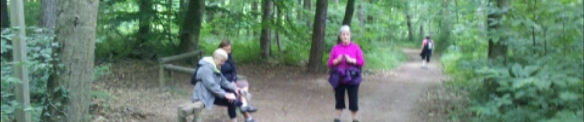
6 participants (Jo,Ca,Ja,Chan,Mi,Da)

Elevation profile

Photos

Points of interest

Positioning

Country:
France
Region :
Grand Est
Department/Province :
Bas-Rhin
Municipality :
Obernai
Location:
Unknown
Start:(UTM)
386739 ; 5369262 (32U) N.

Trails nearby

Trail Walking Ottrott - Le circuit sud du Mur Païen - Photo
Walking
VacheKiri67

Walking

Easy
(2)
Ottrott, Grand Est, Bas-Rhin, France
4.9 km | 6.3 km-effort
1h 56min
No
Trail Walking Ottrott - Le circuit nord du Mur Païen - Photo
Walking
VacheKiri67

Walking

Easy
(1)
Ottrott, Grand Est, Bas-Rhin, France
5.9 km | 8.5 km-effort
2h 4min
No
Trail Walking Ottrott - Le Mont Sainte-Odile depuis Otrott - Photo
Walking
VacheKiri67

Walking

Medium
(1)
Ottrott, Grand Est, Bas-Rhin, France
13 km | 20 km-effort
6h 18min
Yes
Trail Walking Ottrott - Mur Paien complet - Photo
Walking
markrei

Walking

Medium
(1)
Ottrott, Grand Est, Bas-Rhin, France
12 km | 16.4 km-effort
5h 25min
Yes
Trail Walking Obernai - Obernai gare - Mont St Odile - Photo
Walking
tracegps

Walking

Difficult
(2)
Obernai, Grand Est, Bas-Rhin, France
20 km | 29 km-effort
5h 0min
Yes
Trail Mountain bike Barr - Circuit des 3 Petits Ponts - Photo
Mountain bike
tracegps

Mountain bike

Difficult
(1)
Barr, Grand Est, Bas-Rhin, France
15.9 km | 22 km-effort
1h 19min
Yes
Trail Mountain bike Ottrott - Sainte-Odile East-Face - Photo
Mountain bike
tracegps

Mountain bike

Difficult
(1)
Ottrott, Grand Est, Bas-Rhin, France
24 km | 39 km-effort
3h 0min
Yes
Trail On foot Rosheim - Circuit du Vignoble - Photo
On foot
PRO

On foot

Easy
Rosheim, Grand Est, Bas-Rhin, France
8.8 km | 11.7 km-effort
2h 38min
Yes
Trail On foot Bischoffsheim - Circuit des Balcons - Photo
On foot
PRO

On foot

Easy
(1)
Bischoffsheim, Grand Est, Bas-Rhin, France
12.4 km | 15.4 km-effort
3h 30min
Yes


Close
My subscriptions