Randonnée Marche Perpignan - 66 PERPIGNAN, Serrat d'en Vaquer, quartier des aviateurs, Mailloles - Photo

66 PERPIGNAN, Serrat d'en Vaquer, quartier des aviateurs, Mailloles

 jeff66
jeff66

Utilisateur

© OpenStreetMap contributors
Longueur
Longueur
5,6 km
Altitude max
Altitude max
63 m
Dénivelé positif
Dénivelé positif
45 m
Km-Effort
Km-Effort  
6,2 km
Altitude min
Altitude min
35 m
Dénivelé négatif
Dénivelé négatif
45 m
Boucle
Boucle
Oui
Date de création :
2016-03-09 00:00:00.0
Dernière modification :
2016-03-09 00:00:00.0

(0 Avis)

Marche
Marche
56m
Difficulté : Facile

Scannez ce code QR pour ouvrir la randonnée dans l'application SityTrail

Application GPS de randonnée GRATUITE

Logo SityTrail SityTrail

IGN / Instituts géographiques

Télécharger SityTrail sur l'App Store Télécharger SityTrail sur Google Play

Logo SityTrail SityTrail World

Le monde est à vous

Télécharger SityTrail sur l'App Store Télécharger SityTrail sur Google Play Télécharger SityTrail sur Huawei AppGallery

À propos

Randonnée Marche de 5,6 km à découvrir à Occitanie, Pyrénées-Orientales, Perpignan. Cette randonnée est proposée par jeff66.

Description

66 PERPIGNAN, rue henric ARAGON, rues de l'abbé Breuil  - anny de Pous, passage JV Coll-Escluse, av. V.Dalbiez, mas jean, villa St François, cours Maintenon. Aqueduc Les arcades, canal de Perpignan, av. Nungesser et Coli, rue Louis Bleriot, centre commercial E.Leclerc, chemin de Ste Barbe - CR29, rues Anny de Pous et Enric Aragon

Profil altimétrique

Photos

Localisation

Pays :
France
Région :
Occitanie
Département/Province :
Pyrénées-Orientales
Commune :
Perpignan
Localité :
Unknown
Départ:(Dec)
Départ:(UTM)
489873 ; 4725145 (31T) N.

Randonnées à proximité

Randonnée Marche Cabestany - Chemins autour de Cabestany - Photo
Marche
tracegps

Marche

Moyen
(2)
Cabestany, Occitanie, Pyrénées-Orientales, France
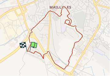
11,8 km | 12,7 km-effort
3h 0min
Oui
Randonnée Marche Perpignan - Perpignan 01.10.2017  - Photo
Marche
jeff66

Marche

Facile
(1)
Perpignan, Occitanie, Pyrénées-Orientales, France
6,7 km | 7,5 km-effort
1h 39min
Non
Randonnée Marche Villeneuve-de-la-Raho - 66 VILLENEUVE-DE-LA-RAHO - grand tour périphérique du lac par les lignes de crêtes  - Photo
Marche
jeff66

Marche

Facile
(2)
Villeneuve-de-la-Raho, Occitanie, Pyrénées-Orientales, France
10 km | 11,5 km-effort
1h 44min
Oui
Randonnée V.T.T. Canohès - canohes - Photo
V.T.T.
haroldtheviking

V.T.T.

Moyen
(2)
Canohès, Occitanie, Pyrénées-Orientales, France
37 km | 44 km-effort
2h 12min
Oui
Randonnée Marche Perpignan - Perpignan  - Photo
Marche
ombrabella

Marche

Très facile
Perpignan, Occitanie, Pyrénées-Orientales, France
18 km | 19,9 km-effort
2h 23min
Non
Randonnée Marche Perpignan - canal Perpignan  - Photo
Marche
Fildesir

Marche

Très facile
Perpignan, Occitanie, Pyrénées-Orientales, France
25 km | 27 km-effort
7h 29min
Non
Randonnée Marche Perpignan - 66 PERPIGNAN, quartier MAV au Bas Vernet  - Photo
Marche
jeff66

Marche

Facile
Perpignan, Occitanie, Pyrénées-Orientales, France
10,7 km | 11,8 km-effort
1h 45min
Oui
Randonnée Marche Perpignan - 66 Perpignan Panchot centre bas Vernet centre del mon - Photo
Marche
jeff66

Marche

Facile
Perpignan, Occitanie, Pyrénées-Orientales, France
8,6 km | 9,3 km-effort
1h 29min
Oui
Randonnée Marche Bompas - 66 BOMPAS - itinéraire partagé piétions cycliste en bord de Tet, berge Têt, Bas Vernet, retour par les canaux et centre ville de BOMPAS  - Photo
Marche
jeff66

Marche

Moyen
Bompas, Occitanie, Pyrénées-Orientales, France
13,4 km | 14,2 km-effort
2h 23min
Oui


Fermer
Mes abonnements