![](/images/other/stat-length.png)
![Randonnée Marche Brée - bree ellikom eetseveld - Photo](https://media.geolcdn.com/t/1900/400/ext.pjpeg?maxdim=2&url=https%3A%2F%2Fstatic1.geolcdn.com%2Fsiteimages%2Fupload%2Ffiles%2F1553511878bg_sport_marche.png)
bree ellikom eetseveld
r.gabriels
Utilisateur
![Longueur](/images/other/stat-length.png)
Longueur
19,2 km
![Altitude max](https://static1.geolcdn.com/siteimages/upload/files/1508320355ic_sort_altitude_max_24dp.png)
Altitude max
80 m
![Dénivelé positif](https://static1.geolcdn.com/siteimages/upload/files/1508320355ic_sort_den_pos_24dp.png)
Dénivelé positif
134 m
![Km-Effort](/images/other/stat-length.png)
Km-Effort
21 km
![Altitude min](https://static1.geolcdn.com/siteimages/upload/files/1508320355ic_sort_altitude_min_24dp.png)
Altitude min
43 m
![Dénivelé négatif](https://static1.geolcdn.com/siteimages/upload/files/1508320355ic_sort_den_neg_24dp.png)
Dénivelé négatif
137 m
![Boucle](https://static1.geolcdn.com/siteimages/upload/files/16400158638029165_repeat_loop_refresh_sync_direction_icon.png)
Boucle
Oui
Date de création :
2018-05-19 00:00:00.0
Dernière modification :
2018-08-28 18:17:52.551
![Marche](https://static1.geolcdn.com/sitytour/trail-icons/101.png)
4h37
Difficulté : Inconnu
![Scannez ce code QR pour ouvrir la randonnée dans l'application SityTrail](https://capi.geolives.com/qq0zvz2zws4bq2lad0pu/sitytour/trails/693968/qr.png?size=200)
Application GPS de randonnée GRATUITE
À propos
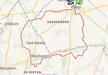
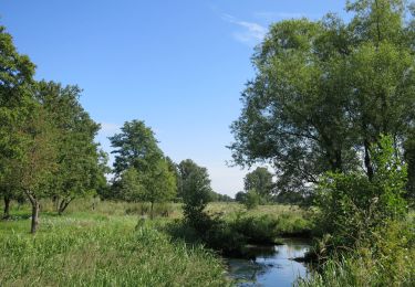
Randonnée Marche de 19,2 km à découvrir à Flandre, Limbourg, Brée. Cette randonnée est proposée par r.gabriels.
Description
Vanuit Bree naar Ellikom, Wijshagen, Boshoven Eetseveld en terug naar Bree. Verharde wegen en goed begaanbare paden ook bij slecht weer.
Localisation
Pays :
Belgique
Région :
Flandre
Département/Province :
Limbourg
Commune :
Brée
Localité :
Brée
Départ:(Dec)
Départ:(UTM)
681688 ; 5668759 (31U) N.
Commentaires
Randonnées à proximité
![Randonnée A pied Bocholt - Abeekvallei Molenroute - Photo](https://media.geolcdn.com/t/375/260/ext.jpg?maxdim=2&url=https%3A%2F%2Fmedia.geolcdn.com%2Ff%2F46c101e1-b756-4ddb-999b-6e1b4d9c3f3c.jpeg)
![A pied A pied](https://static1.geolcdn.com/sitytour/trail-icons/100.png)
Abeekvallei Molenroute
A pied
Moyen
Bocholt,
Flandre,
Limbourg,
Belgique
![](/images/other/stat-length.png)
25 km | 27 km-effort
6h 3min
![](https://static1.geolcdn.com/siteimages/upload/files/16400158638029165_repeat_loop_refresh_sync_direction_icon.png)
Oui
![Randonnée A pied Bocholt - Abeekvallei Rode driehoek - Photo](https://media.geolcdn.com/t/375/260/ext.jpg?maxdim=2&url=https%3A%2F%2Fmedia.geolcdn.com%2Ff%2F6737f183-c31f-44bd-90c9-a5d82b30a5fc.jpeg)
![A pied A pied](https://static1.geolcdn.com/sitytour/trail-icons/100.png)
Abeekvallei Rode driehoek
A pied
Facile
Bocholt,
Flandre,
Limbourg,
Belgique
![](/images/other/stat-length.png)
9,4 km | 10,3 km-effort
2h 21min
![](https://static1.geolcdn.com/siteimages/upload/files/16400158638029165_repeat_loop_refresh_sync_direction_icon.png)
Oui
![Randonnée A pied Bocholt - Abeekvallei Groene rechthoek - Photo](https://media.geolcdn.com/t/375/260/ext.jpg?maxdim=2&url=https%3A%2F%2Fmedia.geolcdn.com%2Ff%2F6737f183-c31f-44bd-90c9-a5d82b30a5fc.jpeg)
![A pied A pied](https://static1.geolcdn.com/sitytour/trail-icons/100.png)
Abeekvallei Groene rechthoek
A pied
Facile
Bocholt,
Flandre,
Limbourg,
Belgique
![](/images/other/stat-length.png)
4,8 km | 5,1 km-effort
1h 9min
![](https://static1.geolcdn.com/siteimages/upload/files/16400158638029165_repeat_loop_refresh_sync_direction_icon.png)
Oui
![Randonnée A pied Brée - Solterheide Groene rechthoek - Photo](https://media.geolcdn.com/t/375/260/ext.jpg?maxdim=2&url=https%3A%2F%2Fmedia.geolcdn.com%2Ff%2Fe0e55db1-5823-42e4-bb44-9519fd8b6dee.jpeg)
![A pied A pied](https://static1.geolcdn.com/sitytour/trail-icons/100.png)
Solterheide Groene rechthoek
A pied
Facile
Brée,
Flandre,
Limbourg,
Belgique
![](/images/other/stat-length.png)
4,8 km | 5,5 km-effort
1h 14min
![](https://static1.geolcdn.com/siteimages/upload/files/16400158638029165_repeat_loop_refresh_sync_direction_icon.png)
Oui
![Randonnée A pied Brée - Solterheide paarse trapezium - Photo](https://media.geolcdn.com/t/375/260/ext.jpg?maxdim=2&url=https%3A%2F%2Fmedia.geolcdn.com%2Ff%2Fe0e55db1-5823-42e4-bb44-9519fd8b6dee.jpeg)
![A pied A pied](https://static1.geolcdn.com/sitytour/trail-icons/100.png)
Solterheide paarse trapezium
A pied
Facile
Brée,
Flandre,
Limbourg,
Belgique
![](/images/other/stat-length.png)
9,3 km | 10,6 km-effort
2h 24min
![](https://static1.geolcdn.com/siteimages/upload/files/16400158638029165_repeat_loop_refresh_sync_direction_icon.png)
Oui
![Randonnée A pied Brée - Solterheide Gele zeshoek - Photo](https://media.geolcdn.com/t/375/260/ext.jpg?maxdim=2&url=https%3A%2F%2Fmedia.geolcdn.com%2Ff%2Fe0e55db1-5823-42e4-bb44-9519fd8b6dee.jpeg)
![A pied A pied](https://static1.geolcdn.com/sitytour/trail-icons/100.png)
Solterheide Gele zeshoek
A pied
Facile
Brée,
Flandre,
Limbourg,
Belgique
![](/images/other/stat-length.png)
12,5 km | 13,9 km-effort
3h 9min
![](https://static1.geolcdn.com/siteimages/upload/files/16400158638029165_repeat_loop_refresh_sync_direction_icon.png)
Oui
![Randonnée A pied Brée - Itterdal Oranje bol - Photo](https://media.geolcdn.com/t/375/260/ext.jpg?maxdim=2&url=https%3A%2F%2Fmedia.geolcdn.com%2Ff%2Fe0e55db1-5823-42e4-bb44-9519fd8b6dee.jpeg)
![A pied A pied](https://static1.geolcdn.com/sitytour/trail-icons/100.png)
Itterdal Oranje bol
A pied
Facile
Brée,
Flandre,
Limbourg,
Belgique
![](/images/other/stat-length.png)
9,4 km | 10,3 km-effort
2h 20min
![](https://static1.geolcdn.com/siteimages/upload/files/16400158638029165_repeat_loop_refresh_sync_direction_icon.png)
Oui
![Randonnée A pied Brée - Itterdal Rode driehoek - Photo](https://media.geolcdn.com/t/375/260/ext.jpg?maxdim=2&url=https%3A%2F%2Fmedia.geolcdn.com%2Ff%2Fe0e55db1-5823-42e4-bb44-9519fd8b6dee.jpeg)
![A pied A pied](https://static1.geolcdn.com/sitytour/trail-icons/100.png)
Itterdal Rode driehoek
A pied
Facile
Brée,
Flandre,
Limbourg,
Belgique
![](/images/other/stat-length.png)
5,1 km | 5,7 km-effort
1h 17min
![](https://static1.geolcdn.com/siteimages/upload/files/16400158638029165_repeat_loop_refresh_sync_direction_icon.png)
Oui
![Randonnée A pied Bocholt - Smeetshof Oranje bol - Photo](https://media.geolcdn.com/t/375/260/ext.jpg?maxdim=2&url=https%3A%2F%2Fmedia.geolcdn.com%2Ff%2F51871d37-7620-4685-b964-b7c5e6ba516a.jpeg)
![A pied A pied](https://static1.geolcdn.com/sitytour/trail-icons/100.png)
Smeetshof Oranje bol
A pied
Facile
Bocholt,
Flandre,
Limbourg,
Belgique
![](/images/other/stat-length.png)
8,7 km | 9,4 km-effort
2h 8min
![](https://static1.geolcdn.com/siteimages/upload/files/16400158638029165_repeat_loop_refresh_sync_direction_icon.png)
Oui