Trail Walking Fanjeaux - Chemin du Piémont Pyrénéen - de Fanjeaux à Mirepoix - Photo

Chemin du Piémont Pyrénéen - de Fanjeaux à Mirepoix

 tracegps
tracegps

User

© OpenStreetMap contributors
Length
Length
26 km
Max alt
Max alt
451 m
Uphill gradient
Uphill gradient
572 m
Km-Effort
Km-Effort  
33 km
Min alt
Min alt
292 m
Downhill gradient
Downhill gradient
594 m
Boucle
Boucle
No
Creation date :
2014-12-10 00:00:00.0
Updated on :
2014-12-10 00:00:00.0

(1 Reviews)

Walking
Walking
6h00
Difficulty : Difficult

Scan this QR Code to open this trail in the SityTrail application

FREE GPS app for hiking

Logo SityTrail SityTrail

IGN / Geographical institutes

Download SityTrail from the App Store Download SityTrail from Google Play

Logo SityTrail SityTrail World

The world is yours!

Download SityTrail from the App Store Download SityTrail from Google Play Download SityTrail on Huawei AppGallery

About

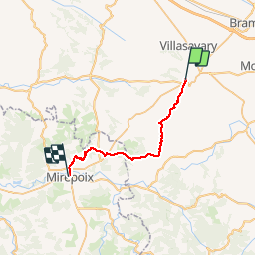
Trail Walking of 26 km to be discovered at Occitania, Aude, Fanjeaux. This trail is proposed by tracegps.

Description

Départ de Fanjeaux, suivre la d119, au premier virage prendre sentier à Gauche, passer Honoux, La Malgoude, traverser la D119, atteindre Mirepoix.

Elevation profile

Photos

Positioning

Country:
France
Region :
Occitania
Department/Province :
Aude
Municipality :
Fanjeaux
Location:
Unknown
Start:(Dec)
Start:(UTM)
421523 ; 4781855 (31T) N.

Comments

Please log in to post a review or rate the element


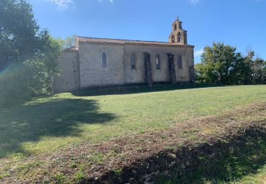
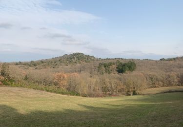
La partie qui va du pal à mirepoix en passant par malegoude n'apporte pas grand chose d'intéressant. Il est préférable, après le pal, de se diriger vers Roumengoux pour bénéficier d'un panorama ouvert sur les Pyrénées. La distance est exactement identique d'un côté comme de l'autre.


Trails nearby

Trail Walking Lasserre-de-Prouille - Lasserre de prouilhe 17 kms - Photo
Walking
cappelle

Walking

Medium
(1)
Lasserre-de-Prouille, Occitania, Aude, France
16.9 km | 21 km-effort
4h 25min
Yes
Trail Walking Fanjeaux - Fanjeaux la hilhe - Photo
Walking
cappelle

Walking

Difficult
(1)
Fanjeaux, Occitania, Aude, France
9.7 km | 13.2 km-effort
3h 0min
No
Trail Mountain bike Villasavary - circuit 3 villasavary - Photo
Mountain bike
leroj73

Mountain bike

Medium
(1)
Villasavary, Occitania, Aude, France
23 km | 30 km-effort
1h 43min
Yes
Trail Walking Laurac - Laurac Fanjeaux - Photo
Walking
tracegps

Walking

Very difficult
(1)
Laurac, Occitania, Aude, France
27 km | 37 km-effort
6h 30min
Yes
Trail Walking Fanjeaux - Fanjeaux  Boucle de la Hille  - Photo
Walking
Mamilaure

Walking

Medium
Fanjeaux, Occitania, Aude, France
13.1 km | 18.3 km-effort
3h 30min
Yes
Trail Walking Fanjeaux - 2023 09 16 CHEMIN du PIÉMONT PYRÉNÉEN - 9ème étapes :  FANGEAUX - HOUNOUX - MALEGOUDE - MIREPOIX - Photo
Walking
LEGUE

Walking

Difficult
Fanjeaux, Occitania, Aude, France
25 km | 33 km-effort
4h 51min
No
Trail Walking Villasavary - Villasavary - Photo
Walking
Christophe Ferreres

Walking

Medium
Villasavary, Occitania, Aude, France
7.8 km | 10.4 km-effort
3h 3min
Yes
Trail Walking Villasavary - Tour de la cité sénateurs... - Photo
Walking
geli.henri

Walking

Very easy
Villasavary, Occitania, Aude, France
36 km | 41 km-effort
2h 17min
No
Trail Walking Lasserre-de-Prouille - Lasserre de prouillhe  - Photo
Walking
cappelle

Walking

Medium
Lasserre-de-Prouille, Occitania, Aude, France
8.9 km | 11.5 km-effort
2h 39min
No


Close
My subscriptions