Trail Walking Lavelanet - boucle ivry Laroque - Photo

boucle ivry Laroque

 jopost
jopost

User

© OpenStreetMap contributors
Length
Length
15.7 km
Max alt
Max alt
584 m
Uphill gradient
Uphill gradient
330 m
Km-Effort
Km-Effort  
20 km
Min alt
Min alt
430 m
Downhill gradient
Downhill gradient
330 m
Boucle
Boucle
Yes
Creation date :
2018-04-17 23:31:49.644
Updated on :
2019-09-02 09:36:30.424

(0 Reviews)

Walking
Walking
3h52
Difficulty : Medium

Scan this QR Code to open this trail in the SityTrail application

FREE GPS app for hiking

Logo SityTrail SityTrail

IGN / Geographical institutes

Download SityTrail from the App Store Download SityTrail from Google Play

Logo SityTrail SityTrail World

The world is yours!

Download SityTrail from the App Store Download SityTrail from Google Play Download SityTrail on Huawei AppGallery

About

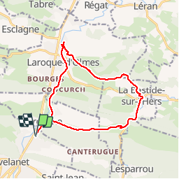
Trail Walking of 15.7 km to be discovered at Occitania, Ariège, Lavelanet. This trail is proposed by jopost.

Description

départ de la gare, voie verte, jusqu'à Dreuilhe, suivre à droite le chemin jusqu'à Ivry, longer la route jusqu'à La Bastide sur l'hers et prendre la voie verte pour revenir à Lavelanet par Laroque d'Olmes.

Elevation profile

Positioning

Country:
France
Region :
Occitania
Department/Province :
Ariège
Municipality :
Lavelanet
Location:
Unknown
Start:(UTM)
406732 ; 4754959 (31T) N.

Trails nearby

Trail Electric bike Lavelanet - Lavelanet Ste Colombe lac Montbel retour Laroque  - Photo
Electric bike
jopost

Electric bike

Medium
Lavelanet, Occitania, Ariège, France
40 km | 44 km-effort
4h 30min
Yes
Trail On foot Laroque-d'Olmes - Les Crètes du Plantaurel - Photo
On foot
PRO

On foot

Easy
Laroque-d'Olmes, Occitania, Ariège, France
11.8 km | 17.3 km-effort
3h 55min
Yes
Trail Walking Lavelanet - Camping Village des Bons-Hommes pour balade-grillade - Photo
Walking
jopost

Walking

Very easy
Lavelanet, Occitania, Ariège, France
4.8 km | 6.5 km-effort
2h 14min
Yes
Trail Walking Lavelanet - BOUCLE Ste Rufine, Raissac, Péreille d'en Bas et Haut, retour Cambière Bensa - Photo
Walking
jopost

Walking

Easy
Lavelanet, Occitania, Ariège, France
13.3 km | 21 km-effort
4h 34min
Yes
Trail Walking Lavelanet - boucle soula le bac  - Photo
Walking
jopost

Walking

Difficult
Lavelanet, Occitania, Ariège, France
7.3 km | 10.8 km-effort
3h 13min
Yes
Trail Walking Lavelanet - Tour de Péreille - Photo
Walking
RR31

Walking

Very easy
Lavelanet, Occitania, Ariège, France
14.7 km | 19.1 km-effort
4h 3min
Yes
Trail Walking Lavelanet - Lavelanet Belesta Ivry - Photo
Walking
RR31

Walking

Medium
Lavelanet, Occitania, Ariège, France
25 km | 32 km-effort
6h 42min
No
Trail Mountain bike Lavelanet - Grande Traversée VTT FFC Ariège Pyrénées - Etape 4 - Lavelanet - Chalabre - Photo
Mountain bike
tracegps

Mountain bike

Easy
Lavelanet, Occitania, Ariège, France
18.3 km | 20 km-effort
1h 19min
No
Trail Walking Lavelanet - Lavelanet Montségur - Sentier des Bons-Hommes vers GR107 - Photo
Walking
jopost

Walking

Easy
Lavelanet, Occitania, Ariège, France
7.8 km | 13.9 km-effort
2h 33min
No


Close
My subscriptions