Trail Walking Ansignan - RP66 ANSIGNAN - aqueduc - rec de la Piquière - ST ARNAC - col de Lacroix - ANSIGNAN - Photo

RP66 ANSIGNAN - aqueduc - rec de la Piquière - ST ARNAC - col de Lacroix - ANSIGNAN

 jeff66
jeff66

User

© OpenStreetMap contributors
Length
Length
11.5 km
Max alt
Max alt
444 m
Uphill gradient
Uphill gradient
349 m
Km-Effort
Km-Effort  
16.1 km
Min alt
Min alt
178 m
Downhill gradient
Downhill gradient
350 m
Boucle
Boucle
Yes
Creation date :
2018-06-26 12:53:50.147
Updated on :
2018-06-26 12:53:50.147

(0 Reviews)

Walking
Walking
2h26
Difficulty : Medium

Scan this QR Code to open this trail in the SityTrail application

FREE GPS app for hiking

Logo SityTrail SityTrail

IGN / Geographical institutes

Download SityTrail from the App Store Download SityTrail from Google Play

Logo SityTrail SityTrail World

The world is yours!

Download SityTrail from the App Store Download SityTrail from Google Play Download SityTrail on Huawei AppGallery

About

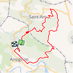
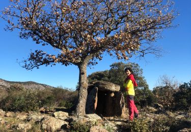
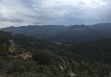
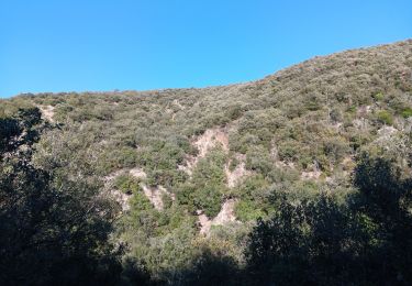
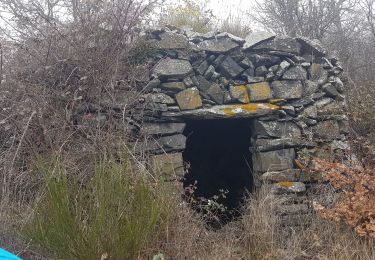
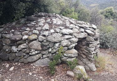
Trail Walking of 11.5 km to be discovered at Occitania, Pyrénées-Orientales, Ansignan. This trail is proposed by jeff66.

Description

RP66 ANSIGNAN - aqueduc - rec de la Piquière - ST ARNAC - les Pujals - RD77 - col de Lacroix - piste DFCI53 - Sarrat Duc - camp de la Mourié - la Couillade du Rentadou - la guarrigue de roque rouge - Condomines - ANSIGNAN

Elevation profile

Positioning

Country:
France
Region :
Occitania
Department/Province :
Pyrénées-Orientales
Municipality :
Ansignan
Location:
Unknown
Start:(UTM)
460388 ; 4734874 (31T) N.

Trails nearby

Trail Walking Trilla - 66 TRILLA - ANSIGNAN aqueduc romain - ballade en Fenouillédes  - Photo
Walking
jeff66

Walking

Difficult
(1)
Trilla, Occitania, Pyrénées-Orientales, France
17.6 km | 26 km-effort
3h 49min
Yes
Trail Walking Caramany - CARAMANY 66 - balcons retenue sur l'Agly  - Photo
Walking
jeff66

Walking

Medium
(3)
Caramany, Occitania, Pyrénées-Orientales, France
25 km | 34 km-effort
3h 59min
Yes
Trail Walking Caramany - caramany - Photo
Walking
66Gribouille83

Walking

Medium
Caramany, Occitania, Pyrénées-Orientales, France
8 km | 11.4 km-effort
3h 27min
Yes
Trail Walking Feilluns - track - Photo
Walking
suresnois

Walking

Very difficult
Feilluns, Occitania, Pyrénées-Orientales, France
17.3 km | 24 km-effort
5h 28min
Yes
Trail Walking Ansignan - 20230105 Ansignan - Photo
Walking
ThonyM

Walking

Medium
Ansignan, Occitania, Pyrénées-Orientales, France
17 km | 27 km-effort
4h 38min
Yes
Trail Walking Lansac - 66 LANSAC - boucle, tour et Roc de LANSAC - Photo
Walking
jeff66

Walking

Medium
Lansac, Occitania, Pyrénées-Orientales, France
6.7 km | 9.5 km-effort
1h 29min
Yes
Trail Walking Ansignan - sentier des dolmens en fenouillèdes - Photo
Walking
stef789

Walking

Easy
Ansignan, Occitania, Pyrénées-Orientales, France
9.7 km | 14.5 km-effort
3h 57min
Yes
Trail Walking Prats-de-Sournia - prats de sournia hetre remarq.419 m 12km  - Photo
Walking
Erius

Walking

Medium
Prats-de-Sournia, Occitania, Pyrénées-Orientales, France
12.6 km | 18.2 km-effort
3h 27min
Yes
Trail Walking Lansac - lansac chemin du coq roc et tour 6km 200m limodore possible  - Photo
Walking
Erius

Walking

Easy
Lansac, Occitania, Pyrénées-Orientales, France
6.1 km | 8.8 km-effort
1h 43min
Yes


Close
My subscriptions