Tocht Stappen Sentheim - Au fil de l'eau - Photo
 helmut68
helmut68

Gebruiker

© OpenStreetMap contributors
Lengte
Lengte
17,8 km
Max. hoogte
Max. hoogte
385 m
Positief hoogteverschil
244 m
Km-Effort
Km-Effort  
21 km
Min. hoogte
Min. hoogte
327 m
Negatief hoogteverschil
246 m
Boucle
Boucle
Ja
Datum van aanmaak :
2019-05-07 01:29:30.104
Laatste wijziging :
2019-05-07 01:29:30.104

(0 Bericht)

Stappen
Stappen
4h13
Moeilijkheid : Gemakkelijk

Scan deze QR-code om de tocht te openen in de SityTrail-applicatie

Gratisgps-wandelapplicatie

Logo SityTrail SityTrail

IGN / Geografische instituten

SityTrail uit de App Store downloaden SityTrail uit Google Play downloaden

Logo SityTrail SityTrail World

De wereld gaat voor u open

SityTrail uit de App Store downloaden SityTrail uit Google Play downloaden SityTrail op Huawei AppGallery downloaden

Over ons

Tocht Stappen van 17,8 km beschikbaar op Grand Est, Haut-Rhin, Sentheim. Deze tocht wordt voorgesteld door helmut68.

Beschrijving

Départ place de jeu de Sentheim,longer la rive gauche de la Doller jusqu'à Guewenheim,puis contourner le lac de Michelbach, profiter de cet bel endroit ,puis revenir par la rive droite de la Doller pour rejoindre Sentheim .

Hoogteprofiel

Foto's

Plaatsbepaling

Land:
France
Regio :
Grand Est
Departement/Provincie :
Haut-Rhin
Gemeente :
Sentheim
Locatie:
Unknown
Vertrek:(Dec)
Vertrek:(UTM)
353912 ; 5290680 (32T) N.

Wandeltochten in de omgeving

Tocht Stappen Masevaux-Niederbruck - Masevaux - Rossberg par le belvédère du Fuchsfelsen - Photo
Stappen
Bart2015

Stappen

Medium
(1)
Masevaux-Niederbruck, Grand Est, Haut-Rhin, France
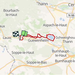
19,9 km | 34 km-effort
4h 44min
Ja
Tocht Stappen Sentheim - Sentheim Rossberg - Photo
Stappen
helmut68

Stappen

Medium
(1)
Sentheim, Grand Est, Haut-Rhin, France
27 km | 40 km-effort
6h 11min
Ja
Tocht Stappen Lauw - 2022-07-14 Marche Lauw Refuge CAF Baerenkopf - Photo
Stappen
GUIDE
holtzv

Stappen

Zeer moeilijk
Lauw, Grand Est, Haut-Rhin, France
18,4 km | 31 km-effort
5h 35min
Neen
Tocht Te voet Sentheim - Sentier géologique du Wolfloch - Photo
Te voet
PRO

Te voet

Gemakkelijk
Sentheim, Grand Est, Haut-Rhin, France
3,8 km | 4,8 km-effort
1h 5min
Neen
Tocht Te voet Sentheim - Sentheim - Bergwald - Eichwald - Guevenheim - Sentheim - Photo
Te voet
patrickbeyrath

Te voet

Gemakkelijk
(1)
Sentheim, Grand Est, Haut-Rhin, France
13,4 km | 16,6 km-effort
Onbekend
Ja
Tocht Stappen Sentheim - Knapphutte Saegenkopf Hütte - Photo
Stappen
helmut68

Stappen

Medium
Sentheim, Grand Est, Haut-Rhin, France
13,8 km | 17,2 km-effort
5h 11min
Ja
Tocht Stappen Sentheim - Montori - Photo
Stappen
helmut68

Stappen

Medium
Sentheim, Grand Est, Haut-Rhin, France
17,7 km | 24 km-effort
4h 47min
Ja
Tocht Mountainbike Sentheim - AperoDioller - Photo
Mountainbike
helmut68

Mountainbike

Gemakkelijk
Sentheim, Grand Est, Haut-Rhin, France
24 km | 27 km-effort
1h 23min
Ja
Tocht Stappen Sentheim - Baerenkopf  - Photo
Stappen
helmut68

Stappen

Moeilijk
Sentheim, Grand Est, Haut-Rhin, France
33 km | 49 km-effort
7h 0min
Ja


Sluiten
Mijn abonnementen