Tocht Mountainbike Bolquère - Espace VTT FFC Pyrénées Catalanes - Circuit n° 5 - Vallée de la Têt - Photo

Espace VTT FFC Pyrénées Catalanes - Circuit n° 5 - Vallée de la Têt

 tracegps
tracegps

Gebruiker

© OpenStreetMap contributors
Lengte
Lengte
10,6 km
Max. hoogte
Max. hoogte
1750 m
Positief hoogteverschil
182 m
Km-Effort
Km-Effort  
13,1 km
Min. hoogte
Min. hoogte
1668 m
Negatief hoogteverschil
182 m
Boucle
Boucle
Ja
Datum van aanmaak :
2014-12-10 00:00:00.0
Laatste wijziging :
2014-12-10 00:00:00.0

(1 Bericht)

Mountainbike
Mountainbike
1h45
Moeilijkheid : Gemakkelijk

Scan deze QR-code om de tocht te openen in de SityTrail-applicatie

Gratisgps-wandelapplicatie

Logo SityTrail SityTrail

IGN / Geografische instituten

SityTrail uit de App Store downloaden SityTrail uit Google Play downloaden

Logo SityTrail SityTrail World

De wereld gaat voor u open

SityTrail uit de App Store downloaden SityTrail uit Google Play downloaden SityTrail op Huawei AppGallery downloaden

Over ons

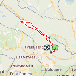
Tocht Mountainbike van 10,6 km beschikbaar op Occitanië, Pyrénées-Orientales, Bolquère. Deze tocht wordt voorgesteld door tracegps.

Beschrijving

Espace VTT FFC Pyrénées Catalanes Circuit labellisé par la Fédération Française de Cyclisme. Départ du parking des Estanyols. Agréable piste forestière. Retour le long de la vallée de la Têt qui invite à de nombreux arrêts bucoliques. Circuit au profil roulant qui emprunte de larges pistes ( pistes de ski de fond en hiver). Le retour est légèrement plus technique.

Hoogteprofiel

Foto's

Plaatsbepaling

Land:
France
Regio :
Occitanië
Departement/Provincie :
Pyrénées-Orientales
Gemeente :
Bolquère
Locatie:
Unknown
Vertrek:(Dec)
Vertrek:(UTM)
424113 ; 4707403 (31T) N.

Opmerkingen

Gelieve in te loggen om een commentaar of een beoordeling achter te laten


Wandeltochten in de omgeving

Tocht Stappen Font-Romeu-Odeillo-Via - Coll del Pam lac des  Bouillouses - Photo
Stappen
jcmartin

Stappen

Medium
(2)
Font-Romeu-Odeillo-Via, Occitanië, Pyrénées-Orientales, France
13,3 km | 19,3 km-effort
4h 10min
Ja
Tocht Sneeuwschoenen Font-Romeu-Odeillo-Via - pic dels moros - Photo
Sneeuwschoenen
jpipacific

Sneeuwschoenen

Medium
(1)
Font-Romeu-Odeillo-Via, Occitanië, Pyrénées-Orientales, France
12,6 km | 19,4 km-effort
4h 46min
Ja
Tocht Stappen Font-Romeu-Odeillo-Via - Font Romeu Egat - Photo
Stappen
crijack

Stappen

Medium
(2)
Font-Romeu-Odeillo-Via, Occitanië, Pyrénées-Orientales, France
2,5 km | 3,4 km-effort
44min
Ja
Tocht Sneeuwschoenen Font-Romeu-Odeillo-Via - Pic dels Moros avec Pierre - Photo
Sneeuwschoenen
jpipacific

Sneeuwschoenen

Medium
(1)
Font-Romeu-Odeillo-Via, Occitanië, Pyrénées-Orientales, France
10,5 km | 15,9 km-effort
4h 4min
Ja
Tocht Stappen Égat - Egat  Puig  Moro - Photo
Stappen
ohelluin

Stappen

Medium
(1)
Égat, Occitanië, Pyrénées-Orientales, France
13,4 km | 19,3 km-effort
4h 51min
Ja
Tocht Stappen Égat - La croix d'Egat - Photo
Stappen
ochamley

Stappen

Gemakkelijk
(1)
Égat, Occitanië, Pyrénées-Orientales, France
7,1 km | 10,4 km-effort
2h 2min
Ja
Tocht Stappen Égat - Le Pic dels Moros - Photo
Stappen
tracegps

Stappen

Moeilijk
(2)
Égat, Occitanië, Pyrénées-Orientales, France
12,1 km | 18,8 km-effort
5h 30min
Ja
Tocht Stappen Eyne - Le Cambre d'Ase - Photo
Stappen
tracegps

Stappen

Moeilijk
(1)
Eyne, Occitanië, Pyrénées-Orientales, France
8,9 km | 22 km-effort
4h 0min
Ja
Tocht Mountainbike Font-Romeu-Odeillo-Via - Espace VTT FFC Pyrénées Catalanes - Circuit n° 6 - Forêt d'Egat - Photo
Mountainbike
tracegps

Mountainbike

Medium
(2)
Font-Romeu-Odeillo-Via, Occitanië, Pyrénées-Orientales, France
7,6 km | 10,1 km-effort
1h 0min
Ja


Sluiten
Mijn abonnementen