Tocht Mountainbike Verdun - Verdun  Caychax - Col d'Arques - Photo

Verdun Caychax - Col d'Arques

 tracegps
tracegps

Gebruiker

© OpenStreetMap contributors
Lengte
Lengte
15,5 km
Max. hoogte
Max. hoogte
963 m
Positief hoogteverschil
602 m
Km-Effort
Km-Effort  
24 km
Min. hoogte
Min. hoogte
567 m
Negatief hoogteverschil
602 m
Boucle
Boucle
Ja
Datum van aanmaak :
2014-12-10 00:00:00.0
Laatste wijziging :
2014-12-10 00:00:00.0

(0 Bericht)

Mountainbike
Mountainbike
2h00
Moeilijkheid : Medium

Scan deze QR-code om de tocht te openen in de SityTrail-applicatie

Gratisgps-wandelapplicatie

Logo SityTrail SityTrail

IGN / Geografische instituten

SityTrail uit de App Store downloaden SityTrail uit Google Play downloaden

Logo SityTrail SityTrail World

De wereld gaat voor u open

SityTrail uit de App Store downloaden SityTrail uit Google Play downloaden SityTrail op Huawei AppGallery downloaden

Over ons

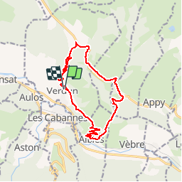
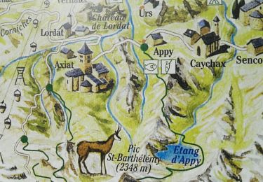
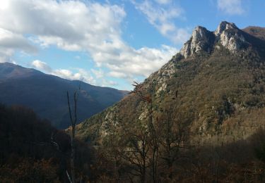
Tocht Mountainbike van 15,5 km beschikbaar op Occitanië, Ariège, Verdun. Deze tocht wordt voorgesteld door tracegps.

Beschrijving

Relevé terrain par les Vttayres du Sabarthès.

Hoogteprofiel

Plaatsbepaling

Land:
France
Regio :
Occitanië
Departement/Provincie :
Ariège
Gemeente :
Verdun
Locatie:
Unknown
Vertrek:(Dec)
Vertrek:(UTM)
392925 ; 4738925 (31T) N.

Wandeltochten in de omgeving

Tocht Stappen Vèbre - rocher de Courbas - Photo
Stappen
chrisgps

Stappen

Gemakkelijk
Vèbre, Occitanië, Ariège, France
14,8 km | 25 km-effort
5h 44min
Ja
Tocht Stappen Larnat - Cap de la Lesse - Photo
Stappen
c.chehere

Stappen

Gemakkelijk
Larnat, Occitanië, Ariège, France
15,5 km | 23 km-effort
5h 41min
Ja
Tocht Stappen Verdun - Verdun, Albies, Vebre - Photo
Stappen
luccio20231

Stappen

Gemakkelijk
Verdun, Occitanië, Ariège, France
4,4 km | 6 km-effort
1h 33min
Neen
Tocht Stappen Vèbre - Vebre, Lassure, La Remise, Vebre - Photo
Stappen
luccio20231

Stappen

Gemakkelijk
Vèbre, Occitanië, Ariège, France
8,1 km | 12,6 km-effort
2h 34min
Ja
Tocht Stappen Vèbre - Vebre, Caychax. Alliés, Vebre - Photo
Stappen
luccio20231

Stappen

Gemakkelijk
Vèbre, Occitanië, Ariège, France
9,6 km | 15,1 km-effort
2h 53min
Neen
Tocht Stappen Larnat - Col de Larnat et Col Doulent - Photo
Stappen
c.chehere

Stappen

Moeilijk
(1)
Larnat, Occitanië, Ariège, France
14,8 km | 23 km-effort
4h 42min
Ja
Tocht Stappen Les Cabannes - Camina des Cabannes à Luzenac - Photo
Stappen
c.chehere

Stappen

Gemakkelijk
Les Cabannes, Occitanië, Ariège, France
8,4 km | 10,6 km-effort
2h 46min
Neen
Tocht Stappen Garanou - Garanou - Photo
Stappen
c.chehere

Stappen

Medium
Garanou, Occitanië, Ariège, France
13,1 km | 19 km-effort
5h 34min
Ja
Tocht Stappen Les Cabannes - chemin des Tuliers n°6 - Photo
Stappen
chrisgps

Stappen

Gemakkelijk
Les Cabannes, Occitanië, Ariège, France
14,1 km | 21 km-effort
4h 30min
Ja


Sluiten
Mijn abonnementen