Tocht Mountainbike Mauvezin - Randonnée VTT - Mauvezin - Photo

Randonnée VTT - Mauvezin

 tracegps
tracegps

Gebruiker

© OpenStreetMap contributors
Lengte
Lengte
15,5 km
Max. hoogte
Max. hoogte
194 m
Positief hoogteverschil
206 m
Km-Effort
Km-Effort  
18,3 km
Min. hoogte
Min. hoogte
116 m
Negatief hoogteverschil
208 m
Boucle
Boucle
Ja
Datum van aanmaak :
2014-12-10 00:00:00.0
Laatste wijziging :
2014-12-10 00:00:00.0

(0 Bericht)

Mountainbike
Mountainbike
1h10
Moeilijkheid : Medium

Scan deze QR-code om de tocht te openen in de SityTrail-applicatie

Gratisgps-wandelapplicatie

Logo SityTrail SityTrail

IGN / Geografische instituten

SityTrail uit de App Store downloaden SityTrail uit Google Play downloaden

Logo SityTrail SityTrail World

De wereld gaat voor u open

SityTrail uit de App Store downloaden SityTrail uit Google Play downloaden SityTrail op Huawei AppGallery downloaden

Over ons

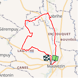
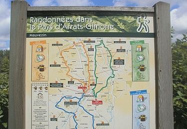
Tocht Mountainbike van 15,5 km beschikbaar op Occitanië, Gers, Mauvezin. Deze tocht wordt voorgesteld door tracegps.

Beschrijving

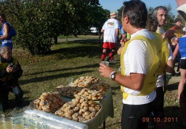
Très beau parcours balisé et très bien entretenu par la Communauté de Communes. Un régal du soir !

Hoogteprofiel

Plaatsbepaling

Land:
France
Regio :
Occitanië
Departement/Provincie :
Gers
Gemeente :
Mauvezin
Locatie:
Unknown
Vertrek:(Dec)
Vertrek:(UTM)
328665 ; 4844256 (31T) N.

Wandeltochten in de omgeving

Tocht Te voet Mauvezin - Wikiloc - Mauvezin Le Gouffre de La Hobio - Photo
Te voet
jeromelacoste

Te voet

Gemakkelijk
(1)
Mauvezin, Occitanië, Gers, France
15,1 km | 18,8 km-effort
Onbekend
Ja
Tocht Te voet Saint-Sauvy - trail cote 12*30 - Photo
Te voet
jeromelacoste

Te voet

Heel gemakkelijk
Saint-Sauvy, Occitanië, Gers, France
8,9 km | 10,6 km-effort
1h 40min
Ja
Tocht Lopen Mauvezin - Ronde des foies gras - Mauvezin - Photo
Lopen
tracegps

Lopen

Moeilijk
Mauvezin, Occitanië, Gers, France
25 km | 29 km-effort
3h 0min
Neen
Tocht Mountainbike Mauvezin - Ronde des foies gras - Mauvezin - Photo
Mountainbike
tracegps

Mountainbike

Medium
Mauvezin, Occitanië, Gers, France
25 km | 29 km-effort
2h 0min
Neen
Tocht Te voet Mauvezin - Circuit des Jonquilles - Photo
Te voet
jeromelacoste

Te voet

Gemakkelijk
Mauvezin, Occitanië, Gers, France
13,4 km | 15,3 km-effort
3h 15min
Ja
Tocht Mountainbike Mauvezin - La Gimone - Sarrant - Photo
Mountainbike
lorenzot54

Mountainbike

Gemakkelijk
Mauvezin, Occitanië, Gers, France
25 km | 29 km-effort
2h 24min
Ja
Tocht Mountainbike Mauvezin - Solomiac-Maubec - Photo
Mountainbike
lorenzot54

Mountainbike

Mauvezin, Occitanië, Gers, France
29 km | 34 km-effort
1h 51min
Ja
Tocht Stappen Mauvezin - Tour de Mauvezin - Photo
Stappen
lorenzot54

Stappen

Mauvezin, Occitanië, Gers, France
4,3 km | 5,2 km-effort
1h 20min
Ja
Tocht Stappen Saint-Antonin - Marie vers Saint sauvy - Photo
Stappen
yves31

Stappen

Heel gemakkelijk
Saint-Antonin, Occitanië, Gers, France
5,8 km | 6,7 km-effort
1h 28min
Neen


Sluiten
Mijn abonnementen