Tocht Stappen Égat - Le Pic dels Moros - Photo
 tracegps
tracegps

Gebruiker

© OpenStreetMap contributors
Lengte
Lengte
12,1 km
Max. hoogte
Max. hoogte
2135 m
Positief hoogteverschil
502 m
Km-Effort
Km-Effort  
18,8 km
Min. hoogte
Min. hoogte
1723 m
Negatief hoogteverschil
500 m
Boucle
Boucle
Ja
Datum van aanmaak :
2014-12-10 00:00:00.0
Laatste wijziging :
2014-12-10 00:00:00.0

(2 Bericht)

Stappen
Stappen
5h30
Moeilijkheid : Moeilijk

Scan deze QR-code om de tocht te openen in de SityTrail-applicatie

Gratisgps-wandelapplicatie

Logo SityTrail SityTrail

IGN / Geografische instituten

SityTrail uit de App Store downloaden SityTrail uit Google Play downloaden

Logo SityTrail SityTrail World

De wereld gaat voor u open

SityTrail uit de App Store downloaden SityTrail uit Google Play downloaden SityTrail op Huawei AppGallery downloaden

Over ons

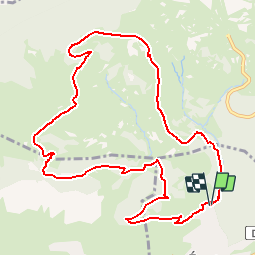
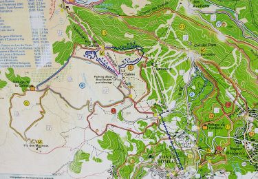
Tocht Stappen van 12,1 km beschikbaar op Occitanië, Pyrénées-Orientales, Égat. Deze tocht wordt voorgesteld door tracegps.

Beschrijving

Une randonnée en boucle vers le Pic dels Moros et le refuge de la Calma depuis Egat. D’autres informations et photos sont disponibles ICI Balade proposée par « Les Balades et Randonnées de Fred »

Hoogteprofiel

Foto's

Plaatsbepaling

Land:
France
Regio :
Occitanië
Departement/Provincie :
Pyrénées-Orientales
Gemeente :
Égat
Locatie:
Unknown
Vertrek:(Dec)
Vertrek:(UTM)
419330 ; 4706599 (31T) N.

Opmerkingen

Gelieve in te loggen om een commentaar of een beoordeling achter te laten


Super


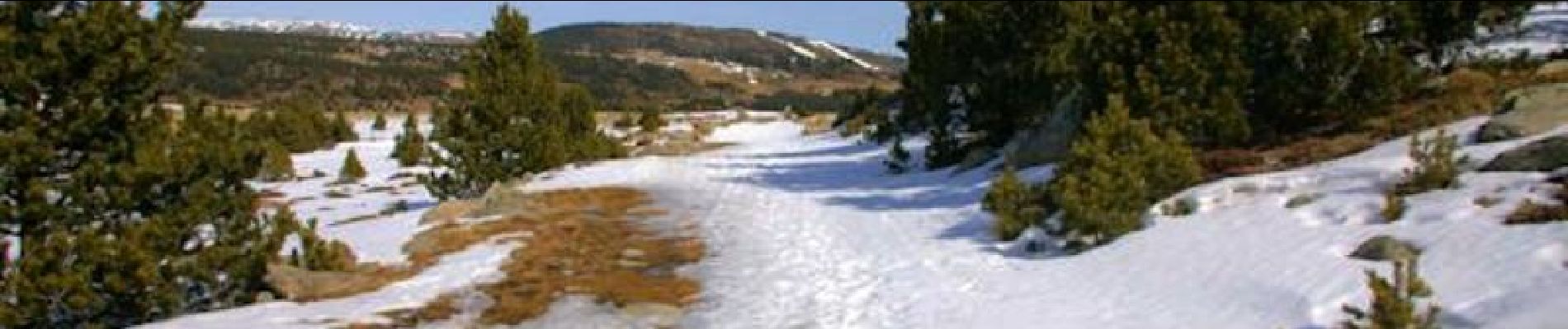
Visiblement une version hivernale, qui en été tourne à la rando pâturages - "sanglier". A noter : le départ se fait juste sous le parking, piste tracée (par au-dessus l'été avec les clôtures ça ne passe pas).


Wandeltochten in de omgeving

Tocht Stappen Font-Romeu-Odeillo-Via - Coll del Pam lac des  Bouillouses - Photo
Stappen
jcmartin

Stappen

Medium
(2)
Font-Romeu-Odeillo-Via, Occitanië, Pyrénées-Orientales, France
13,3 km | 19,3 km-effort
4h 10min
Ja
Tocht Sneeuwschoenen Font-Romeu-Odeillo-Via - pic dels moros - Photo
Sneeuwschoenen
jpipacific

Sneeuwschoenen

Medium
(1)
Font-Romeu-Odeillo-Via, Occitanië, Pyrénées-Orientales, France
12,6 km | 19,4 km-effort
4h 46min
Ja
Tocht Stappen Font-Romeu-Odeillo-Via - Font Romeu Egat - Photo
Stappen
crijack

Stappen

Medium
(2)
Font-Romeu-Odeillo-Via, Occitanië, Pyrénées-Orientales, France
2,5 km | 3,4 km-effort
44min
Ja
Tocht Sneeuwschoenen Font-Romeu-Odeillo-Via - Pic dels Moros avec Pierre - Photo
Sneeuwschoenen
jpipacific

Sneeuwschoenen

Medium
(1)
Font-Romeu-Odeillo-Via, Occitanië, Pyrénées-Orientales, France
10,5 km | 15,9 km-effort
4h 4min
Ja
Tocht Stappen Égat - Egat  Puig  Moro - Photo
Stappen
ohelluin

Stappen

Medium
(1)
Égat, Occitanië, Pyrénées-Orientales, France
13,4 km | 19,3 km-effort
4h 51min
Ja
Tocht Stappen Égat - La croix d'Egat - Photo
Stappen
ochamley

Stappen

Gemakkelijk
(1)
Égat, Occitanië, Pyrénées-Orientales, France
7,1 km | 10,4 km-effort
2h 2min
Ja
Tocht Mountainbike Font-Romeu-Odeillo-Via - Espace VTT FFC Pyrénées Catalanes - Circuit n° 6 - Forêt d'Egat - Photo
Mountainbike
tracegps

Mountainbike

Medium
(2)
Font-Romeu-Odeillo-Via, Occitanië, Pyrénées-Orientales, France
7,6 km | 10,1 km-effort
1h 0min
Ja
Tocht Stappen Bolquère - bolqueres - Photo
Stappen
foxtay

Stappen

Heel gemakkelijk
(1)
Bolquère, Occitanië, Pyrénées-Orientales, France
3,8 km | 4,6 km-effort
1h 1min
Ja
Tocht Noords wandelen Font-Romeu-Odeillo-Via - mauroux - Photo
Noords wandelen
oliviercaty

Noords wandelen

Medium
(2)
Font-Romeu-Odeillo-Via, Occitanië, Pyrénées-Orientales, France
11,2 km | 14,7 km-effort
1h 20min
Ja


Sluiten
Mijn abonnementen