Tocht Mountainbike Vernon - Circuit « Les quartiers » - Vernon  - Photo

Circuit « Les quartiers » - Vernon

 tracegps
tracegps

Gebruiker

© OpenStreetMap contributors
Lengte
Lengte
5,6 km
Max. hoogte
Max. hoogte
63 m
Positief hoogteverschil
58 m
Km-Effort
Km-Effort  
6,3 km
Min. hoogte
Min. hoogte
14 m
Negatief hoogteverschil
57 m
Boucle
Boucle
Ja
Datum van aanmaak :
2014-12-10 00:00:00.0
Laatste wijziging :
2014-12-10 00:00:00.0

(0 Bericht)

Mountainbike
Mountainbike
30m
Moeilijkheid : Gemakkelijk

Scan deze QR-code om de tocht te openen in de SityTrail-applicatie

Gratisgps-wandelapplicatie

Logo SityTrail SityTrail

IGN / Geografische instituten

SityTrail uit de App Store downloaden SityTrail uit Google Play downloaden

Logo SityTrail SityTrail World

De wereld gaat voor u open

SityTrail uit de App Store downloaden SityTrail uit Google Play downloaden SityTrail op Huawei AppGallery downloaden

Over ons

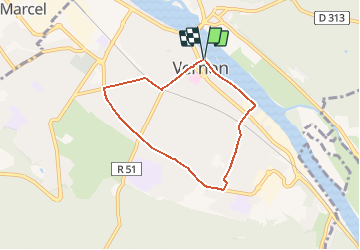
Tocht Mountainbike van 5,6 km beschikbaar op Normandië, Eure, Vernon. Deze tocht wordt voorgesteld door tracegps.

Beschrijving

Circuit proposé par la commune de Vernon. Départ de «Vernon Plage» (à coté du square J et R Laurence) à Vernon. Aucune difficulté, parcours bitumé accessible aux vélos. Retrouvez les circuits de Vernon sur le site de Vernon.

Hoogteprofiel

Foto's

Plaatsbepaling

Land:
France
Regio :
Normandië
Departement/Provincie :
Eure
Gemeente :
Vernon
Locatie:
Unknown
Vertrek:(Dec)
Vertrek:(UTM)
389714 ; 5438862 (31U) N.

Wandeltochten in de omgeving

Tocht Stappen Giverny - 076-104-Giverny Matin 12km-526-030- - Photo
Stappen
rvs147

Stappen

Gemakkelijk
(2)
Giverny, Normandië, Eure, France
9,2 km | 11,5 km-effort
2h 32min
Ja
Tocht Stappen La Chapelle-Longueville - Saint Just - Les coteaux de Seine - Photo
Stappen
marcel.F

Stappen

Gemakkelijk
(4)
La Chapelle-Longueville, Normandië, Eure, France
10,5 km | 13,8 km-effort
2h 57min
Ja
Tocht Stappen Vernon - Les falaises de Seine de Vernon à Mantes la Jolie - Photo
Stappen
chessyca

Stappen

Moeilijk
Vernon, Normandië, Eure, France
37 km | 47 km-effort
7h 38min
Neen
Tocht Stappen Giverny - Giverny Le lézard vert - Photo
Stappen
Marie-Claire-mcp

Stappen

Moeilijk
Giverny, Normandië, Eure, France
5,7 km | 7,5 km-effort
1h 57min
Neen
Tocht Stappen Giverny - Giverny : les coteaux vers le Vexin 13 km - Photo
Stappen
MichelRando7656

Stappen

Heel gemakkelijk
Giverny, Normandië, Eure, France
14,7 km | 17,8 km-effort
4h 51min
Neen
Tocht Motor Giverny - Giverny , les Coteaux avril 2019 - Photo
Motor
MichelRando7656

Motor

Medium
Giverny, Normandië, Eure, France
13,6 km | 16,5 km-effort
3h 28min
Neen
Tocht Motor Giverny - Giverny , les Coteaux avril 2019 - Photo
Motor
MichelRando7656

Motor

Medium
Giverny, Normandië, Eure, France
13,6 km | 16,5 km-effort
3h 28min
Neen
Tocht Motor Giverny - Giverny , les Coteaux avril 2019 - Photo
Motor
MichelRando7656

Motor

Medium
Giverny, Normandië, Eure, France
13,6 km | 16,5 km-effort
3h 28min
Neen
Tocht Mountainbike Vernon - Les prés de Vernonnet - Vernon - Photo
Mountainbike
tracegps

Mountainbike

Gemakkelijk
Vernon, Normandië, Eure, France
3,3 km | 3,7 km-effort
19min
Ja


Sluiten
Mijn abonnementen