![](/images/other/stat-length.png)
![Tocht Mountainbike Farschviller - Autour du Lehtrisch - Photo](https://media.geolcdn.com/t/1900/400/ext.pjpeg?maxdim=2&url=https%3A%2F%2Fstatic1.geolcdn.com%2Fsiteimages%2Fupload%2Ffiles%2F1524743154velo.jpg)
Autour du Lehtrisch
Renard57
Gebruiker
![Lengte](/images/other/stat-length.png)
Lengte
27 km
![Max. hoogte](https://static1.geolcdn.com/siteimages/upload/files/1508320355ic_sort_altitude_max_24dp.png)
Max. hoogte
281 m
![Positief hoogteverschil](https://static1.geolcdn.com/siteimages/upload/files/1508320355ic_sort_den_pos_24dp.png)
Positief hoogteverschil
405 m
![Km-Effort](/images/other/stat-length.png)
Km-Effort
32 km
![Min. hoogte](https://static1.geolcdn.com/siteimages/upload/files/1508320355ic_sort_altitude_min_24dp.png)
Min. hoogte
210 m
![Negatief hoogteverschil](https://static1.geolcdn.com/siteimages/upload/files/1508320355ic_sort_den_neg_24dp.png)
Negatief hoogteverschil
404 m
![Boucle](https://static1.geolcdn.com/siteimages/upload/files/16400158638029165_repeat_loop_refresh_sync_direction_icon.png)
Boucle
Ja
Datum van aanmaak :
2014-12-10 00:00:00.0
Laatste wijziging :
2014-12-10 00:00:00.0
![Mountainbike](https://static1.geolcdn.com/sitytour/trail-icons/202.png)
3h02
Moeilijkheid : Medium
![Scan deze QR-code om de tocht te openen in de SityTrail-applicatie](https://capi.geolives.com/qq0zvz2zws4bq2lad0pu/sitytour/trails/147111/qr.png?size=200)
Gratisgps-wandelapplicatie
Over ons
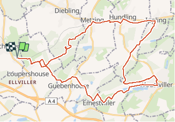
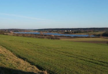
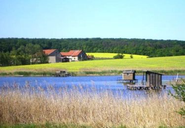
Tocht Mountainbike van 27 km beschikbaar op Grand Est, Moselle, Farschviller. Deze tocht wordt voorgesteld door Renard57.
Beschrijving
Parcours sympa avec une alternance entre chemin forestier, sentier VTT en forêt et un peu de macadam. Accessible à presque tout le monde.
Plaatsbepaling
Land:
France
Regio :
Grand Est
Departement/Provincie :
Moselle
Gemeente :
Farschviller
Locatie:
Unknown
Vertrek:(Dec)
Vertrek:(UTM)
347100 ; 5439368 (32U) N.
Opmerkingen
Wandeltochten in de omgeving
![Tocht Stappen Metzing - Metzing Loupershouse - Photo](https://media.geolcdn.com/t/375/260/ext.jpg?maxdim=2&url=https%3A%2F%2Fservices.sitytrail.com%2FGeolivesWS%2FDownloadMedia.ashx%3FTrailID%3D263513%26Media%3D367e893c-fc82-4add-aa03-b7ee25465948.JPG)
![Stappen Stappen](https://static1.geolcdn.com/sitytour/trail-icons/101.png)
Metzing Loupershouse
Stappen
Gemakkelijk
(1)
Metzing,
Grand Est,
Moselle,
France
![](/images/other/stat-length.png)
8,7 km | 10,7 km-effort
2h 18min
![](https://static1.geolcdn.com/siteimages/upload/files/16400158638029165_repeat_loop_refresh_sync_direction_icon.png)
Ja
![Tocht Te voet Hoste - Circuit de Guten Brunnen - Photo](https://media.geolcdn.com/t/375/260/ext.jpg?maxdim=2&url=https%3A%2F%2Fmedia.geolcdn.com%2Ff%2F7a25f4ff-22c1-4802-8200-db89b7c4b482.jpeg)
![Te voet Te voet](https://static1.geolcdn.com/sitytour/trail-icons/100.png)
Circuit de Guten Brunnen
Te voet
Gemakkelijk
Hoste,
Grand Est,
Moselle,
France
![](/images/other/stat-length.png)
11,5 km | 14 km-effort
3h 11min
![](https://static1.geolcdn.com/siteimages/upload/files/16400158638029165_repeat_loop_refresh_sync_direction_icon.png)
Ja
![Tocht Stappen Loupershouse - Autour de Metzing - Guebenhouse - Photo](https://media.geolcdn.com/t/375/260/ext.jpg?maxdim=2&url=https%3A%2F%2Fstatic1.geolcdn.com%2Fsiteimages%2Fupload%2Ffiles%2F1553511878bg_sport_marche.png)
![Stappen Stappen](https://static1.geolcdn.com/sitytour/trail-icons/101.png)
Autour de Metzing - Guebenhouse
Stappen
Gemakkelijk
(1)
Loupershouse,
Grand Est,
Moselle,
France
![](/images/other/stat-length.png)
12,3 km | 15,6 km-effort
3h 19min
![](https://static1.geolcdn.com/siteimages/upload/files/16400158638029165_repeat_loop_refresh_sync_direction_icon.png)
Ja
![Tocht Te voet Hoste - Circuit de la ligne Maginot Aquatique - Photo](https://media.geolcdn.com/t/375/260/ext.jpg?maxdim=2&url=https%3A%2F%2Fmedia.geolcdn.com%2Ff%2F7a25f4ff-22c1-4802-8200-db89b7c4b482.jpeg)
![Te voet Te voet](https://static1.geolcdn.com/sitytour/trail-icons/100.png)
Circuit de la ligne Maginot Aquatique
Te voet
Gemakkelijk
Hoste,
Grand Est,
Moselle,
France
![](/images/other/stat-length.png)
4,7 km | 5,6 km-effort
1h 16min
![](https://static1.geolcdn.com/siteimages/upload/files/16400158638029165_repeat_loop_refresh_sync_direction_icon.png)
Neen
![Tocht Stappen Saint-Jean-Rohrbach - lac diefenbach - Photo](https://media.geolcdn.com/t/375/260/ext.jpg?maxdim=2&url=https%3A%2F%2Fservices.sitytrail.com%2FGeolivesWS%2FDownloadMedia.ashx%3FTrailID%3D359422%26Media%3Dfix__20140817174802.jpg)
![Stappen Stappen](https://static1.geolcdn.com/sitytour/trail-icons/101.png)
lac diefenbach
Stappen
Gemakkelijk
Saint-Jean-Rohrbach,
Grand Est,
Moselle,
France
![](/images/other/stat-length.png)
4,4 km | 5,5 km-effort
1h 14min
![](https://static1.geolcdn.com/siteimages/upload/files/16400158638029165_repeat_loop_refresh_sync_direction_icon.png)
Ja
![Tocht Stappen Hoste - Randonnée de Hoste à Barst - Photo](https://media.geolcdn.com/t/375/260/ext.jpg?maxdim=2&url=https%3A%2F%2Fservices.sitytrail.com%2FGeolivesWS%2FDownloadMedia.ashx%3FTrailID%3D191455%26Media%3D15048_1.jpg)
![Stappen Stappen](https://static1.geolcdn.com/sitytour/trail-icons/101.png)
Randonnée de Hoste à Barst
Stappen
Medium
Hoste,
Grand Est,
Moselle,
France
![](/images/other/stat-length.png)
13,7 km | 16,1 km-effort
3h 0min
![](https://static1.geolcdn.com/siteimages/upload/files/16400158638029165_repeat_loop_refresh_sync_direction_icon.png)
Ja
![Tocht Mountainbike Puttelange-aux-Lacs - Randonnée au Pays des Lacs - Puttelange aux Lacs - Photo](https://media.geolcdn.com/t/375/260/ext.jpg?maxdim=2&url=https%3A%2F%2Fservices.sitytrail.com%2FGeolivesWS%2FDownloadMedia.ashx%3FTrailID%3D103623%26Media%3D6013_2.jpg)
![Mountainbike Mountainbike](https://static1.geolcdn.com/sitytour/trail-icons/202.png)
Randonnée au Pays des Lacs - Puttelange aux Lacs
Mountainbike
Moeilijk
(1)
Puttelange-aux-Lacs,
Grand Est,
Moselle,
France
![](/images/other/stat-length.png)
56 km | 69 km-effort
4h 0min
![](https://static1.geolcdn.com/siteimages/upload/files/16400158638029165_repeat_loop_refresh_sync_direction_icon.png)
Ja
![Tocht Stappen Hoste - Chemin de crête - Photo](https://media.geolcdn.com/t/375/260/ext.jpg?maxdim=2&url=https%3A%2F%2Fmedia.geolcdn.com%2Ff%2Fb91cfe2f-73f5-491e-b3c0-984d426b6af0.JPG)
![Stappen Stappen](https://static1.geolcdn.com/sitytour/trail-icons/101.png)
Chemin de crête
Stappen
Medium
Hoste,
Grand Est,
Moselle,
France
![](/images/other/stat-length.png)
8,8 km | 10,2 km-effort
2h 19min
![](https://static1.geolcdn.com/siteimages/upload/files/16400158638029165_repeat_loop_refresh_sync_direction_icon.png)
Ja
![Tocht Stappen Hoste - étangs hoste - Photo](https://media.geolcdn.com/t/375/260/ext.jpg?maxdim=2&url=https%3A%2F%2Fmedia.geolcdn.com%2Ff%2F1436f472-a72f-4c5d-95b3-1074657cfa71.jpg)
![Stappen Stappen](https://static1.geolcdn.com/sitytour/trail-icons/101.png)
étangs hoste
Stappen
Gemakkelijk
Hoste,
Grand Est,
Moselle,
France
![](/images/other/stat-length.png)
16,6 km | 19,3 km-effort
3h 28min
![](https://static1.geolcdn.com/siteimages/upload/files/16400158638029165_repeat_loop_refresh_sync_direction_icon.png)
Ja