Tocht Stappen Guewenheim - Circuit de la Doller  - Photo

Circuit de la Doller

 domi68440
domi68440

Gebruiker

© OpenStreetMap contributors
Lengte
Lengte
10,7 km
Max. hoogte
Max. hoogte
357 m
Positief hoogteverschil
110 m
Km-Effort
Km-Effort  
12,2 km
Min. hoogte
Min. hoogte
297 m
Negatief hoogteverschil
110 m
Boucle
Boucle
Ja
Datum van aanmaak :
2019-08-05 07:14:34.391
Laatste wijziging :
2019-08-05 15:55:58.978

(0 Bericht)

Stappen
Stappen
2h24
Moeilijkheid : Medium

Scan deze QR-code om de tocht te openen in de SityTrail-applicatie

Gratisgps-wandelapplicatie

Logo SityTrail SityTrail

IGN / Geografische instituten

SityTrail uit de App Store downloaden SityTrail uit Google Play downloaden

Logo SityTrail SityTrail World

De wereld gaat voor u open

SityTrail uit de App Store downloaden SityTrail uit Google Play downloaden SityTrail op Huawei AppGallery downloaden

Over ons

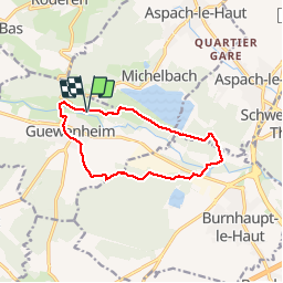
Tocht Stappen van 10,7 km beschikbaar op Grand Est, Haut-Rhin, Guewenheim. Deze tocht wordt voorgesteld door domi68440.

Beschrijving

Au départ du camping de Guewenheim,  

Hoogteprofiel

Foto's

Plaatsbepaling

Land:
France
Regio :
Grand Est
Departement/Provincie :
Haut-Rhin
Gemeente :
Guewenheim
Locatie:
Unknown
Vertrek:(UTM)
357518 ; 5290906 (32T) N.

Wandeltochten in de omgeving

Tocht Stappen Sentheim - Sentheim Rossberg - Photo
Stappen
helmut68

Stappen

Medium
(1)
Sentheim, Grand Est, Haut-Rhin, France
27 km | 40 km-effort
6h 11min
Ja
Tocht Te voet Sentheim - Sentier géologique du Wolfloch - Photo
Te voet
PRO

Te voet

Gemakkelijk
Sentheim, Grand Est, Haut-Rhin, France
3,8 km | 4,8 km-effort
1h 5min
Neen
Tocht Te voet Sentheim - Sentheim - Bergwald - Eichwald - Guevenheim - Sentheim - Photo
Te voet
patrickbeyrath

Te voet

Gemakkelijk
(1)
Sentheim, Grand Est, Haut-Rhin, France
13,4 km | 16,6 km-effort
Onbekend
Ja
Tocht Stappen Sentheim - Knapphutte Saegenkopf Hütte - Photo
Stappen
helmut68

Stappen

Medium
Sentheim, Grand Est, Haut-Rhin, France
13,8 km | 17,2 km-effort
5h 11min
Ja
Tocht Stappen Burnhaupt-le-Haut - Rando du 09/02/2024 par Alain...Pont d'Aspach - Photo
Stappen
boubou68

Stappen

Zeer moeilijk
Burnhaupt-le-Haut, Grand Est, Haut-Rhin, France
22 km | 27 km-effort
5h 12min
Ja
Tocht Stappen Sentheim - Montori - Photo
Stappen
helmut68

Stappen

Medium
Sentheim, Grand Est, Haut-Rhin, France
17,7 km | 24 km-effort
4h 47min
Ja
Tocht Mountainbike Sentheim - AperoDioller - Photo
Mountainbike
helmut68

Mountainbike

Gemakkelijk
Sentheim, Grand Est, Haut-Rhin, France
24 km | 27 km-effort
1h 23min
Ja
Tocht Stappen Sentheim - Baerenkopf  - Photo
Stappen
helmut68

Stappen

Moeilijk
Sentheim, Grand Est, Haut-Rhin, France
33 km | 49 km-effort
7h 0min
Ja
Tocht Stappen Sentheim - Lac Seigneurie Soultzbach - Photo
Stappen
helmut68

Stappen

Gemakkelijk
Sentheim, Grand Est, Haut-Rhin, France
10,9 km | 12,7 km-effort
3h 26min
Ja


Sluiten
Mijn abonnementen