Tocht Te voet Dracy-lès-Couches - V2019.15.10 Dracy-Les-Couches randonnée douce - Photo

V2019.15.10 Dracy-Les-Couches randonnée douce

 clabidault
clabidault

Gebruiker

© OpenStreetMap contributors
Lengte
Lengte
9,2 km
Max. hoogte
Max. hoogte
454 m
Positief hoogteverschil
195 m
Km-Effort
Km-Effort  
11,8 km
Min. hoogte
Min. hoogte
338 m
Negatief hoogteverschil
195 m
Boucle
Boucle
Ja
Datum van aanmaak :
2019-10-06 17:10:54.455
Laatste wijziging :
2020-09-18 14:03:37.852

(0 Bericht)

Te voet
Te voet
--
Moeilijkheid : Heel gemakkelijk

Scan deze QR-code om de tocht te openen in de SityTrail-applicatie

Gratisgps-wandelapplicatie

Logo SityTrail SityTrail

IGN / Geografische instituten

SityTrail uit de App Store downloaden SityTrail uit Google Play downloaden

Logo SityTrail SityTrail World

De wereld gaat voor u open

SityTrail uit de App Store downloaden SityTrail uit Google Play downloaden SityTrail op Huawei AppGallery downloaden

Over ons

Tocht Te voet van 9,2 km beschikbaar op Bourgondië-Franche-Comté, Saône-et-Loire, Dracy-lès-Couches. Deze tocht wordt voorgesteld door clabidault.

Hoogteprofiel

Plaatsbepaling

Land:
France
Regio :
Bourgondië-Franche-Comté
Departement/Provincie :
Saône-et-Loire
Gemeente :
Dracy-lès-Couches
Locatie:
Unknown
Vertrek:(UTM)
620154 ; 5193996 (31T) N.

Wandeltochten in de omgeving

Tocht Stappen Saint-Maurice-lès-Couches - Saint Maurice les Couches  GRS (gde) - Photo
Stappen
Malice0093

Stappen

Moeilijk
(1)
Saint-Maurice-lès-Couches, Bourgondië-Franche-Comté, Saône-et-Loire, France
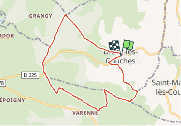
11,5 km | 15,3 km-effort
3h 29min
Ja
Tocht Stappen Saint-Sernin-du-Plain - Mazenay les deux monts page 17 - Photo
Stappen
grasgilbert

Stappen

Zeer moeilijk
(1)
Saint-Sernin-du-Plain, Bourgondië-Franche-Comté, Saône-et-Loire, France
13,5 km | 19,4 km-effort
4h 24min
Ja
Tocht Stappen Couches - couches saint jean de trézy - Photo
Stappen
patourad

Stappen

Gemakkelijk
(1)
Couches, Bourgondië-Franche-Comté, Saône-et-Loire, France
11 km | 14,4 km-effort
3h 3min
Ja
Tocht Stappen Saint-Léger-sur-Dheune - Circuit n°1 de Saint Leger sur Dheune - Photo
Stappen
tracegps

Stappen

Gemakkelijk
Saint-Léger-sur-Dheune, Bourgondië-Franche-Comté, Saône-et-Loire, France
8 km | 10,2 km-effort
2h 0min
Ja
Tocht Te voet Saint-Gervais-sur-Couches - Le sentier de la Lou - Photo
Te voet
PRO

Te voet

Gemakkelijk
Saint-Gervais-sur-Couches, Bourgondië-Franche-Comté, Saône-et-Loire, France
6,3 km | 8,4 km-effort
1h 54min
Neen
Tocht Te voet Dracy-lès-Couches - Les Balcons de Dracy - Photo
Te voet
PRO

Te voet

Gemakkelijk
Dracy-lès-Couches, Bourgondië-Franche-Comté, Saône-et-Loire, France
7,4 km | 9,2 km-effort
2h 5min
Ja
Tocht Stappen Saint-Maurice-lès-Couches - 20190418 Saint Maurice les couches fait - Photo
Stappen
sami55

Stappen

Heel gemakkelijk
Saint-Maurice-lès-Couches, Bourgondië-Franche-Comté, Saône-et-Loire, France
14,1 km | 18,5 km-effort
3h 46min
Ja
Tocht Mountainbike Couches - La Couchoise 2013  - Photo
Mountainbike
tofp21

Mountainbike

Medium
Couches, Bourgondië-Franche-Comté, Saône-et-Loire, France
33 km | 43 km-effort
2h 54min
Ja
Tocht Mountainbike Couches - La Couchoise 2009 - Photo
Mountainbike
tracegps

Mountainbike

Moeilijk
Couches, Bourgondië-Franche-Comté, Saône-et-Loire, France
42 km | 55 km-effort
4h 0min
Ja


Sluiten
Mijn abonnementen