


vat tu...

LAHUPPEAndre
Gebruiker
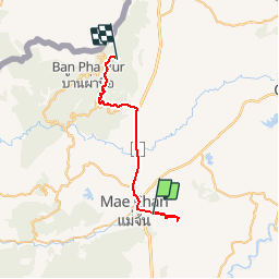

Lengte
40 km

Max. hoogte
1377 m

Positief hoogteverschil
1510 m
Km-Effort
57 km

Min. hoogte
394 m

Negatief hoogteverschil
561 m
Boucle
Neen
Datum van aanmaak :
2019-11-08 01:04:09.618
Laatste wijziging :
2019-11-08 16:24:55.903
1h53
Moeilijkheid : Heel gemakkelijk

Gratisgps-wandelapplicatie
 SityTrail
IGN / Geografische instituten
SityTrail World
De wereld gaat voor u open
Over ons
Tocht 4x4 van 40 km beschikbaar op จังหวัดเชียงราย. Deze tocht wordt voorgesteld door LAHUPPEAndre.
Foto's

Plaatsbepaling
Land:
Thailand
Regio :
จังหวัดเชียงราย
Departement/Provincie :
Unknown
Gemeente :
Unknown
Locatie:
Unknown
Vertrek:(Dec)
Vertrek:(UTM)
591691 ; 2227455 (47Q) N.
Opmerkingen
Wandeltochten in de omgeving