Tocht Andere activiteiten Sembrancher - peter2 - Photo
 Damien6
Damien6

Gebruiker

© OpenStreetMap contributors
Lengte
Lengte
54 km
Max. hoogte
Max. hoogte
3809 m
Positief hoogteverschil
9681 m
Km-Effort
Km-Effort  
181 km
Min. hoogte
Min. hoogte
549 m
Negatief hoogteverschil
9236 m
Boucle
Boucle
Neen
Datum van aanmaak :
2014-12-11 00:00:00.0
Laatste wijziging :
2014-12-11 00:00:00.0

(0 Bericht)

Andere activiteiten
Andere activiteiten
--
Moeilijkheid : Onbekend

Scan deze QR-code om de tocht te openen in de SityTrail-applicatie

Gratisgps-wandelapplicatie

Logo SityTrail SityTrail

IGN / Geografische instituten

SityTrail uit de App Store downloaden SityTrail uit Google Play downloaden

Logo SityTrail SityTrail World

De wereld gaat voor u open

SityTrail uit de App Store downloaden SityTrail uit Google Play downloaden SityTrail op Huawei AppGallery downloaden

Over ons

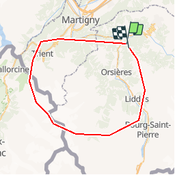
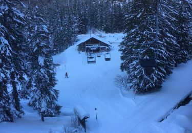
Tocht Andere activiteiten van 54 km beschikbaar op Valais/Wallis, Entremont, Sembrancher. Deze tocht wordt voorgesteld door Damien6.

Beschrijving

Tour sympathique qui vous fait découvrir tous les apsects de la forêt autour de la coline.

Hoogteprofiel

Plaatsbepaling

Land:
Switzerland
Regio :
Valais/Wallis
Departement/Provincie :
Entremont
Gemeente :
Sembrancher
Locatie:
Unknown
Vertrek:(Dec)
Vertrek:(UTM)
358158 ; 5103319 (32T) N.

Wandeltochten in de omgeving

Tocht Te voet Val de Bagnes - Vollèges - Levron - Photo
Te voet
PRO

Te voet

Gemakkelijk
Val de Bagnes, Valais/Wallis, Entremont, Switzerland
3,3 km | 7,8 km-effort
1h 46min
Neen
Tocht Te voet Val de Bagnes - Chemins pédestre, région Entremont - Photo
Te voet
PRO

Te voet

Gemakkelijk
Val de Bagnes, Valais/Wallis, Entremont, Switzerland
3,5 km | 5,8 km-effort
1h 18min
Neen
Tocht Te voet Orsières - sentier du Devin - Photo
Te voet
PRO

Te voet

Gemakkelijk
Orsières, Valais/Wallis, Entremont, Switzerland
3,9 km | 6,7 km-effort
1h 31min
Ja
Tocht Te voet Val de Bagnes - Vollèges - Levron - Photo
Te voet
PRO

Te voet

Gemakkelijk
Val de Bagnes, Valais/Wallis, Entremont, Switzerland
5,4 km | 10,3 km-effort
2h 20min
Neen
Tocht Te voet Orsières - Chemins pédestre, commune d'Orsières - Photo
Te voet
PRO

Te voet

Gemakkelijk
Orsières, Valais/Wallis, Entremont, Switzerland
5,4 km | 14,1 km-effort
3h 12min
Neen
Tocht Te voet Val de Bagnes - Sentier des mines - Photo
Te voet
PRO

Te voet

Gemakkelijk
Val de Bagnes, Valais/Wallis, Entremont, Switzerland
3,7 km | 5,4 km-effort
1h 13min
Ja
Tocht Te voet Val de Bagnes - Bruson - Moay - Photo
Te voet
PRO

Te voet

Gemakkelijk
Val de Bagnes, Valais/Wallis, Entremont, Switzerland
3,6 km | 10 km-effort
2h 16min
Neen
Tocht Sneeuwschoenen Orsières - Champex Lac - La Breya - Champex Lac - Photo
Sneeuwschoenen
jpksenicz

Sneeuwschoenen

Medium
Orsières, Valais/Wallis, Entremont, Switzerland
8,8 km | 18,2 km-effort
3h 1min
Ja
Tocht Stappen Orsières - CMX ZRMT Étape 2 Champex Cabane de Mille  - Photo
Stappen
jeff2

Stappen

Medium
Orsières, Valais/Wallis, Entremont, Switzerland
17,9 km | 38 km-effort
7h 15min
Neen


Sluiten
Mijn abonnementen