Tocht Stappen Bouxières-aux-Chênes - Bouxières-aux-Chênes (Blanzey) 10 000m +238m - Photo

Bouxières-aux-Chênes (Blanzey) 10 000m +238m

 DanielROLLET
DanielROLLET

Gebruiker

© OpenStreetMap contributors
Lengte
Lengte
10 km
Max. hoogte
Max. hoogte
381 m
Positief hoogteverschil
238 m
Km-Effort
Km-Effort  
13,1 km
Min. hoogte
Min. hoogte
219 m
Negatief hoogteverschil
236 m
Boucle
Boucle
Ja
Datum van aanmaak :
2021-12-02 08:00:12.351
Laatste wijziging :
2021-12-02 13:43:32.183

(0 Bericht)

Stappen
Stappen
2h25
Moeilijkheid : Gemakkelijk

Scan deze QR-code om de tocht te openen in de SityTrail-applicatie

Gratisgps-wandelapplicatie

Logo SityTrail SityTrail

IGN / Geografische instituten

SityTrail uit de App Store downloaden SityTrail uit Google Play downloaden

Logo SityTrail SityTrail World

De wereld gaat voor u open

SityTrail uit de App Store downloaden SityTrail uit Google Play downloaden SityTrail op Huawei AppGallery downloaden

Over ons

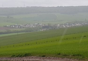
Tocht Stappen van 10 km beschikbaar op Grand Est, Meurthe-et-Moselle, Bouxières-aux-Chênes. Deze tocht wordt voorgesteld door DanielROLLET.

Beschrijving

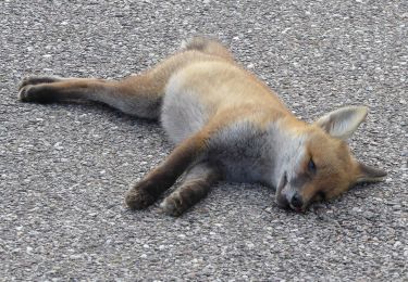
2021 12 02 - Marche nordique  - 9h00 à 11h25 - 3 participants
Temps couvert et pluvieux la 1ère heure, Léger vent.
Trop lent (avec Laurent) mais terrain gras

Hoogteprofiel

Plaatsbepaling

Land:
France
Regio :
Grand Est
Departement/Provincie :
Meurthe-et-Moselle
Gemeente :
Bouxières-aux-Chênes
Locatie:
Unknown
Vertrek:(UTM)
297624 ; 5404521 (32U) N.

Wandeltochten in de omgeving

Tocht Te voet Agincourt - Circuit M - Photo
Te voet
PRO

Te voet

Gemakkelijk
Agincourt, Grand Est, Meurthe-et-Moselle, France
13,3 km | 17,8 km-effort
4h 3min
Neen
Tocht Te voet Lay-Saint-Christophe - Circuit L - Photo
Te voet
PRO

Te voet

Gemakkelijk
Lay-Saint-Christophe, Grand Est, Meurthe-et-Moselle, France
14,7 km | 18,5 km-effort
4h 11min
Ja
Tocht Stappen Leyr - LEYR - LE PLATEAU DE LA ROCHETTE - Photo
Stappen
jean-marie.parachini

Stappen

Gemakkelijk
Leyr, Grand Est, Meurthe-et-Moselle, France
12,1 km | 15,5 km-effort
5h 59min
Ja
Tocht Stappen Montenoy - MONTENOY - LE COL DE VASSUCHAMP - Photo
Stappen
jean-marie.parachini

Stappen

Gemakkelijk
Montenoy, Grand Est, Meurthe-et-Moselle, France
12,4 km | 16,4 km-effort
4h 33min
Ja
Tocht Stappen Eulmont - 2020-12-11_18h42m13_Eulmont_La tour du Crany_10kms - Photo
Stappen
Marin B

Stappen

Moeilijk
(1)
Eulmont, Grand Est, Meurthe-et-Moselle, France
9,6 km | 12,6 km-effort
2h 51min
Ja
Tocht Stappen Dommartemont - Dommartemont  - Photo
Stappen
JJG54

Stappen

Medium
Dommartemont, Grand Est, Meurthe-et-Moselle, France
29 km | 34 km-effort
3h 5min
Neen
Tocht Stappen Bouxières-aux-Chênes - tour crany 29/5/2019 - Photo
Stappen
Morel54

Stappen

Heel gemakkelijk
(1)
Bouxières-aux-Chênes, Grand Est, Meurthe-et-Moselle, France
11,1 km | 14 km-effort
3h 42min
Ja
Tocht Stappen Lay-Saint-Christophe - lay saint Christophe le moulin noir - Photo
Stappen
jean-marie.parachini

Stappen

Gemakkelijk
Lay-Saint-Christophe, Grand Est, Meurthe-et-Moselle, France
12,4 km | 14 km-effort
3h 25min
Ja
Tocht Te voet Faulx - Circuit L : Variant Faulx - Photo
Te voet
PRO

Te voet

Gemakkelijk
Faulx, Grand Est, Meurthe-et-Moselle, France
6,3 km | 6,9 km-effort
1h 34min
Neen


Sluiten
Mijn abonnementen