Tocht Te voet Unknown - Hiking around Monemvasia (Route P2) - Photo

Tous les sentiers balisés d’Europe GUIDE+

© OpenStreetMap contributors
Lengte
Lengte
7,7 km
Max. hoogte
Max. hoogte
428 m
Positief hoogteverschil
400 m
Km-Effort
Km-Effort  
12,5 km
Min. hoogte
Min. hoogte
79 m
Negatief hoogteverschil
255 m
Boucle
Boucle
Neen
Markering
Markering
Datum van aanmaak :
2022-02-21 10:15:57.533
Laatste wijziging :
2022-03-08 16:02:38.032

(0 Bericht)

Te voet
Te voet
2h50
Moeilijkheid : Gemakkelijk

Scan deze QR-code om de tocht te openen in de SityTrail-applicatie

Gratisgps-wandelapplicatie

Logo SityTrail SityTrail

IGN / Geografische instituten

SityTrail uit de App Store downloaden SityTrail uit Google Play downloaden

Logo SityTrail SityTrail World

De wereld gaat voor u open

SityTrail uit de App Store downloaden SityTrail uit Google Play downloaden SityTrail op Huawei AppGallery downloaden

Over ons

Tocht Te voet van 7,7 km beschikbaar op Peloponnesos, West-Griekenland en Ionische Eilanden, Laconië. Deze tocht wordt voorgesteld door SityTrail - itinéraires balisés pédestres.

Beschrijving

Trail created by Cultural Association of Koulendia (2008).

Symbol: red dot on rocks

Hoogteprofiel

Plaatsbepaling

Land:
Greece
Regio :
Peloponnesos, West-Griekenland en Ionische Eilanden
Departement/Provincie :
Laconië
Gemeente :
Unknown
Locatie:
Unknown
Vertrek:(UTM)
680785 ; 4060162 (34S) N.

Wandeltochten in de omgeving

Tocht Stappen  - Monenvasia  - Photo
Stappen
Lobin

Stappen

Moeilijk
, Peloponnesos, West-Griekenland en Ionische Eilanden, Laconië, Greece
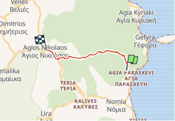
4,3 km | 6,4 km-effort
1h 31min
Neen


Sluiten
Mijn abonnementen