Trail On foot Unknown - Hiking around Monemvasia (Route P2) - Photo

Tous les sentiers balisés d’Europe PRO

© OpenStreetMap contributors
Length
Length
7.7 km
Max alt
Max alt
428 m
Uphill gradient
Uphill gradient
400 m
Km-Effort
Km-Effort  
12.5 km
Min alt
Min alt
79 m
Downhill gradient
Downhill gradient
255 m
Boucle
Boucle
No
Signpost
Signpost
Creation date :
2022-02-21 10:15:57.533
Updated on :
2022-03-08 16:02:38.032

(0 Reviews)

On foot
On foot
2h50
Difficulty : Easy

Scan this QR Code to open this trail in the SityTrail application

FREE GPS app for hiking

Logo SityTrail SityTrail

IGN / Geographical institutes

Download SityTrail from the App Store Download SityTrail from Google Play

Logo SityTrail SityTrail World

The world is yours!

Download SityTrail from the App Store Download SityTrail from Google Play Download SityTrail on Huawei AppGallery

About

Trail On foot of 7.7 km to be discovered at Peloponnese, Western Greece and the Ionian, Laconia Regional Unit. This trail is proposed by SityTrail - itinéraires balisés pédestres.

Description

Trail created by Cultural Association of Koulendia (2008).

Symbol: red dot on rocks

Positioning

Country:
Greece
Region :
Peloponnese, Western Greece and the Ionian
Department/Province :
Laconia Regional Unit
Municipality :
Unknown
Location:
Unknown
Start:(UTM)
680785 ; 4060162 (34S) N.

Trails nearby

Trail Walking  - Monenvasia  - Photo
Walking
Lobin

Walking

Difficult
, Peloponnese, Western Greece and the Ionian, Laconia Regional Unit, Greece
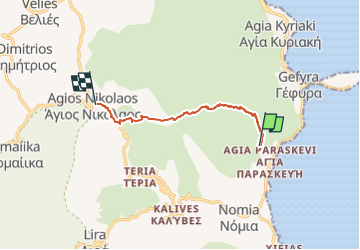
4.3 km | 6.4 km-effort
1h 31min
No


Close
My subscriptions