Tocht Stappen Eyne - Vallée d'Eyne - Photo
 nadinebondoux
nadinebondoux

Gebruiker GUIDE

© OpenStreetMap contributors
Lengte
Lengte
10,7 km
Max. hoogte
Max. hoogte
2123 m
Positief hoogteverschil
517 m
Km-Effort
Km-Effort  
17,6 km
Min. hoogte
Min. hoogte
1603 m
Negatief hoogteverschil
517 m
Boucle
Boucle
Ja
Datum van aanmaak :
2022-07-29 07:01:27.95
Laatste wijziging :
2022-07-29 12:01:22.936

(0 Bericht)

Stappen
Stappen
4h40
Moeilijkheid : Medium

Scan deze QR-code om de tocht te openen in de SityTrail-applicatie

Gratisgps-wandelapplicatie

Logo SityTrail SityTrail

IGN / Geografische instituten

SityTrail uit de App Store downloaden SityTrail uit Google Play downloaden

Logo SityTrail SityTrail World

De wereld gaat voor u open

SityTrail uit de App Store downloaden SityTrail uit Google Play downloaden SityTrail op Huawei AppGallery downloaden

Over ons

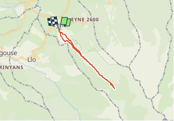
Tocht Stappen van 10,7 km beschikbaar op Occitanië, Pyrénées-Orientales, Eyne. Deze tocht wordt voorgesteld door nadinebondoux.

Beschrijving

départ maison de la vallée
reserve naturelle, chiens interdits

Hoogteprofiel

Foto's

21 fotos in totaal. Klik op een foto om ze allemaal in de galerij weer te geven.

Plaatsbepaling

Land:
France
Regio :
Occitanië
Departement/Provincie :
Pyrénées-Orientales
Gemeente :
Eyne
Locatie:
Unknown
Vertrek:(UTM)
424487 ; 4702286 (31T) N.

Wandeltochten in de omgeving

Tocht Stappen Eyne - Eyne,col de Nuria,pic d'Eyne,Torre d'Eyne,Eyne. - Photo
Stappen
Machaon6

Stappen

Zeer moeilijk
(1)
Eyne, Occitanië, Pyrénées-Orientales, France
24 km | 43 km-effort
8h 44min
Ja
Tocht Sneeuwschoenen Font-Romeu-Odeillo-Via - pic dels moros - Photo
Sneeuwschoenen
jpipacific

Sneeuwschoenen

Medium
(1)
Font-Romeu-Odeillo-Via, Occitanië, Pyrénées-Orientales, France
12,6 km | 19,4 km-effort
4h 46min
Ja
Tocht Stappen Font-Romeu-Odeillo-Via - Font Romeu Egat - Photo
Stappen
crijack

Stappen

Medium
(2)
Font-Romeu-Odeillo-Via, Occitanië, Pyrénées-Orientales, France
2,5 km | 3,4 km-effort
44min
Ja
Tocht Sneeuwschoenen Font-Romeu-Odeillo-Via - Pic dels Moros avec Pierre - Photo
Sneeuwschoenen
jpipacific

Sneeuwschoenen

Medium
(1)
Font-Romeu-Odeillo-Via, Occitanië, Pyrénées-Orientales, France
10,5 km | 15,9 km-effort
4h 4min
Ja
Tocht Stappen Planès - étang de Planès - Photo
Stappen
fhascoet

Stappen

Medium
(2)
Planès, Occitanië, Pyrénées-Orientales, France
10,8 km | 19,6 km-effort
3h 54min
Neen
Tocht Stappen Égat - La croix d'Egat - Photo
Stappen
ochamley

Stappen

Gemakkelijk
(1)
Égat, Occitanië, Pyrénées-Orientales, France
7,1 km | 10,4 km-effort
2h 2min
Ja
Tocht Stappen Eyne - Le Cambre d'Ase - Photo
Stappen
tracegps

Stappen

Moeilijk
(1)
Eyne, Occitanië, Pyrénées-Orientales, France
8,9 km | 22 km-effort
4h 0min
Ja
Tocht Mountainbike Font-Romeu-Odeillo-Via - Espace VTT FFC Pyrénées Catalanes - Circuit n° 6 - Forêt d'Egat - Photo
Mountainbike
tracegps

Mountainbike

Medium
(2)
Font-Romeu-Odeillo-Via, Occitanië, Pyrénées-Orientales, France
7,6 km | 10,1 km-effort
1h 0min
Ja
Tocht Stappen Saint-Pierre-dels-Forcats - bains  de St Thomas  - Photo
Stappen
Ptitjack30

Stappen

Medium
(1)
Saint-Pierre-dels-Forcats, Occitanië, Pyrénées-Orientales, France
8,6 km | 12,2 km-effort
2h 42min
Neen


Sluiten
Mijn abonnementen