Tocht Stappen Eyne - Eyne,col de Nuria,pic d'Eyne,Torre d'Eyne,Eyne. - Photo

Eyne,col de Nuria,pic d'Eyne,Torre d'Eyne,Eyne.

 Machaon6
Machaon6

Gebruiker

© OpenStreetMap contributors
Lengte
Lengte
24 km
Max. hoogte
Max. hoogte
2810 m
Positief hoogteverschil
1437 m
Km-Effort
Km-Effort  
43 km
Min. hoogte
Min. hoogte
1584 m
Negatief hoogteverschil
1437 m
Boucle
Boucle
Ja
Datum van aanmaak :
2018-01-11 00:00:00.0
Laatste wijziging :
2018-01-11 00:00:00.0

(1 Bericht)

Stappen
Stappen
8h44
Moeilijkheid : Zeer moeilijk

Scan deze QR-code om de tocht te openen in de SityTrail-applicatie

Gratisgps-wandelapplicatie

Logo SityTrail SityTrail

IGN / Geografische instituten

SityTrail uit de App Store downloaden SityTrail uit Google Play downloaden

Logo SityTrail SityTrail World

De wereld gaat voor u open

SityTrail uit de App Store downloaden SityTrail uit Google Play downloaden SityTrail op Huawei AppGallery downloaden

Over ons

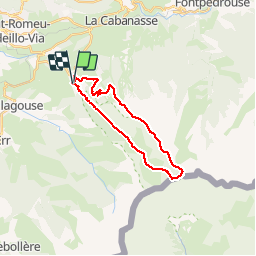
Tocht Stappen van 24 km beschikbaar op Occitanië, Pyrénées-Orientales, Eyne. Deze tocht wordt voorgesteld door Machaon6.

Beschrijving

Départ parking de la réserve-1600m

Hoogteprofiel

Foto's

Plaatsbepaling

Land:
France
Regio :
Occitanië
Departement/Provincie :
Pyrénées-Orientales
Gemeente :
Eyne
Locatie:
Unknown
Vertrek:(Dec)
Vertrek:(UTM)
424505 ; 4702335 (31T) N.

Opmerkingen

Gelieve in te loggen om een commentaar of een beoordeling achter te laten


très pratique


Wandeltochten in de omgeving

Tocht Sneeuwschoenen Font-Romeu-Odeillo-Via - pic dels moros - Photo
Sneeuwschoenen
jpipacific

Sneeuwschoenen

Medium
(1)
Font-Romeu-Odeillo-Via, Occitanië, Pyrénées-Orientales, France
12,6 km | 19,4 km-effort
4h 46min
Ja
Tocht Stappen Font-Romeu-Odeillo-Via - Font Romeu Egat - Photo
Stappen
crijack

Stappen

Medium
(2)
Font-Romeu-Odeillo-Via, Occitanië, Pyrénées-Orientales, France
2,5 km | 3,4 km-effort
44min
Ja
Tocht Sneeuwschoenen Font-Romeu-Odeillo-Via - Pic dels Moros avec Pierre - Photo
Sneeuwschoenen
jpipacific

Sneeuwschoenen

Medium
(1)
Font-Romeu-Odeillo-Via, Occitanië, Pyrénées-Orientales, France
10,5 km | 15,9 km-effort
4h 4min
Ja
Tocht Stappen Planès - étang de Planès - Photo
Stappen
fhascoet

Stappen

Medium
(2)
Planès, Occitanië, Pyrénées-Orientales, France
10,8 km | 19,6 km-effort
3h 54min
Neen
Tocht Stappen Égat - La croix d'Egat - Photo
Stappen
ochamley

Stappen

Gemakkelijk
(1)
Égat, Occitanië, Pyrénées-Orientales, France
7,1 km | 10,4 km-effort
2h 2min
Ja
Tocht Stappen Eyne - Le Cambre d'Ase - Photo
Stappen
tracegps

Stappen

Moeilijk
(1)
Eyne, Occitanië, Pyrénées-Orientales, France
8,9 km | 22 km-effort
4h 0min
Ja
Tocht Mountainbike Font-Romeu-Odeillo-Via - Espace VTT FFC Pyrénées Catalanes - Circuit n° 6 - Forêt d'Egat - Photo
Mountainbike
tracegps

Mountainbike

Medium
(2)
Font-Romeu-Odeillo-Via, Occitanië, Pyrénées-Orientales, France
7,6 km | 10,1 km-effort
1h 0min
Ja
Tocht Stappen Eyne - Vallée d'Eyne - Photo
Stappen
GUIDE
nadinebondoux

Stappen

Medium
Eyne, Occitanië, Pyrénées-Orientales, France
10,7 km | 17,6 km-effort
4h 40min
Ja
Tocht Stappen Saint-Pierre-dels-Forcats - bains  de St Thomas  - Photo
Stappen
Ptitjack30

Stappen

Medium
(1)
Saint-Pierre-dels-Forcats, Occitanië, Pyrénées-Orientales, France
8,6 km | 12,2 km-effort
2h 42min
Neen


Sluiten
Mijn abonnementen