Tocht Stappen Chaillé-les-Marais - Les 5 abbés - Photo
 philturp
philturp

Gebruiker

© OpenStreetMap contributors
Lengte
Lengte
12,7 km
Max. hoogte
Max. hoogte
13 m
Positief hoogteverschil
57 m
Km-Effort
Km-Effort  
13,5 km
Min. hoogte
Min. hoogte
-1 m
Negatief hoogteverschil
58 m
Boucle
Boucle
Ja
Datum van aanmaak :
2014-12-10 00:00:00.0
Laatste wijziging :
2014-12-10 00:00:00.0

(0 Bericht)

Stappen
Stappen
3h00
Moeilijkheid : Gemakkelijk

Scan deze QR-code om de tocht te openen in de SityTrail-applicatie

Gratisgps-wandelapplicatie

Logo SityTrail SityTrail

IGN / Geografische instituten

SityTrail uit de App Store downloaden SityTrail uit Google Play downloaden

Logo SityTrail SityTrail World

De wereld gaat voor u open

SityTrail uit de App Store downloaden SityTrail uit Google Play downloaden SityTrail op Huawei AppGallery downloaden

Over ons

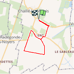
Tocht Stappen van 12,7 km beschikbaar op Pays de la Loire, Vendée, Chaillé-les-Marais. Deze tocht wordt voorgesteld door philturp.

Beschrijving

Ce sentier qui part d’un îlot calcaire issu du Golfe des Pictons, vous
fera découvrir les canaux qui quadrillent nos terres et assurent la fonction
d’évacuation des eaux vers la mer. L’assèchement des terres environnantes s’est
effectué en plusieurs étapes. Au XIIe (sous l’impulsion des grandes Abbayes), puis
au XVIIe s. (engagé par Henry IV, mais effectué sous Louis XIII).

Hoogteprofiel

POI's

POI Chaillé-les-Marais - Table d'orientation - Photo
philturp
CHAILLÉ-LES-MARAIS 
POI Chaillé-les-Marais - Le village de l’An VII - Photo
philturp
CHAILLÉ-LES-MARAIS 
POI Chaillé-les-Marais - La Heronnière du Pain Béni - Photo
philturp
CHAILLÉ-LES-MARAIS 
POI Chaillé-les-Marais - La 137 - Photo
philturp
CHAILLÉ-LES-MARAIS 
POI Chaillé-les-Marais - Flore méditérannéenne, vous dites...? - Photo
philturp
POI Chaillé-les-Marais - L’agriculture en Marais desséché - Photo
philturp
POI Chaillé-les-Marais - Le melon - Photo
philturp
CHAILLÉ-LES-MARAIS 
POI Chaillé-les-Marais - Le Canal des 5 Abbés - Photo
philturp
CHAILLÉ-LES-MARAIS 
POI Chaillé-les-Marais - Les roselières - Photo
philturp
CHAILLÉ-LES-MARAIS 

Plaatsbepaling

Land:
France
Regio :
Pays de la Loire
Departement/Provincie :
Vendée
Gemeente :
Chaillé-les-Marais
Locatie:
Unknown
Vertrek:(Dec)
Vertrek:(UTM)
652336 ; 5139509 (30T) N.

Wandeltochten in de omgeving

Tocht Fiets Sainte-Radégonde-des-Noyers - vacances - routes de campagne en Vendée - Photo
Fiets
anne.vandendries

Fiets

Heel gemakkelijk
Sainte-Radégonde-des-Noyers, Pays de la Loire, Vendée, France
20 km | 21 km-effort
1h 29min
Ja
Tocht Stappen Le Langon - 85 LE LANGON - Photo
Stappen
maioy

Stappen

Heel gemakkelijk
Le Langon, Pays de la Loire, Vendée, France
9,9 km | 10,4 km-effort
2h 0min
Ja


Sluiten
Mijn abonnementen