Trail Walking Chaillé-les-Marais - Les 5 abbés - Photo
 philturp
philturp

User

© OpenStreetMap contributors
Length
Length
12.7 km
Max alt
Max alt
13 m
Uphill gradient
Uphill gradient
57 m
Km-Effort
Km-Effort  
13.5 km
Min alt
Min alt
-1 m
Downhill gradient
Downhill gradient
58 m
Boucle
Boucle
Yes
Creation date :
2014-12-10 00:00:00.0
Updated on :
2014-12-10 00:00:00.0

(0 Reviews)

Walking
Walking
3h00
Difficulty : Easy

Scan this QR Code to open this trail in the SityTrail application

FREE GPS app for hiking

Logo SityTrail SityTrail

IGN / Geographical institutes

Download SityTrail from the App Store Download SityTrail from Google Play

Logo SityTrail SityTrail World

The world is yours!

Download SityTrail from the App Store Download SityTrail from Google Play Download SityTrail on Huawei AppGallery

About

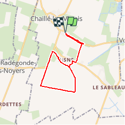
Trail Walking of 12.7 km to be discovered at Pays de la Loire, Vendée, Chaillé-les-Marais. This trail is proposed by philturp.

Description

Ce sentier qui part d’un îlot calcaire issu du Golfe des Pictons, vous
fera découvrir les canaux qui quadrillent nos terres et assurent la fonction
d’évacuation des eaux vers la mer. L’assèchement des terres environnantes s’est
effectué en plusieurs étapes. Au XIIe (sous l’impulsion des grandes Abbayes), puis
au XVIIe s. (engagé par Henry IV, mais effectué sous Louis XIII).

Elevation profile

Points of interest

Point of interest Chaillé-les-Marais - Table d'orientation - Photo
philturp
CHAILLÉ-LES-MARAIS 
Point of interest Chaillé-les-Marais - Le village de l’An VII - Photo
philturp
CHAILLÉ-LES-MARAIS 
Point of interest Chaillé-les-Marais - La Heronnière du Pain Béni - Photo
philturp
CHAILLÉ-LES-MARAIS 
Point of interest Chaillé-les-Marais - La 137 - Photo
philturp
CHAILLÉ-LES-MARAIS 
Point of interest Chaillé-les-Marais - Flore méditérannéenne, vous dites...? - Photo
philturp
Point of interest Chaillé-les-Marais - L’agriculture en Marais desséché - Photo
philturp
Point of interest Chaillé-les-Marais - Le melon - Photo
philturp
CHAILLÉ-LES-MARAIS 
Point of interest Chaillé-les-Marais - Le Canal des 5 Abbés - Photo
philturp
CHAILLÉ-LES-MARAIS 
Point of interest Chaillé-les-Marais - Les roselières - Photo
philturp
CHAILLÉ-LES-MARAIS 

Positioning

Country:
France
Region :
Pays de la Loire
Department/Province :
Vendée
Municipality :
Chaillé-les-Marais
Location:
Unknown
Start:(UTM)
652336 ; 5139509 (30T) N.

Trails nearby

Trail Cycle Sainte-Radégonde-des-Noyers - vacances - routes de campagne en Vendée - Photo
Cycle
anne.vandendries

Cycle

Very easy
Sainte-Radégonde-des-Noyers, Pays de la Loire, Vendée, France
20 km | 21 km-effort
1h 29min
Yes
Trail Walking Vouillé-les-Marais - le Jard - Photo
Walking
Texier Fabien

Walking

Easy
Vouillé-les-Marais, Pays de la Loire, Vendée, France
1.1 km | 1.1 km-effort
19min
Yes
Trail Walking Le Langon - 85 LE LANGON - Photo
Walking
maioy

Walking

Very easy
Le Langon, Pays de la Loire, Vendée, France
9.9 km | 10.4 km-effort
2h 0min
Yes


Close
My subscriptions