Tocht Stappen Estagel - ESTAGEL Chapelle St Laurent MARDI FAIT - Photo

ESTAGEL Chapelle St Laurent MARDI FAIT

 MarcOBRECHT
MarcOBRECHT

Gebruiker

© OpenStreetMap contributors
Lengte
Lengte
12,2 km
Max. hoogte
Max. hoogte
241 m
Positief hoogteverschil
353 m
Km-Effort
Km-Effort  
16,9 km
Min. hoogte
Min. hoogte
75 m
Negatief hoogteverschil
353 m
Boucle
Boucle
Ja
Datum van aanmaak :
2024-04-21 08:14:48.459
Laatste wijziging :
2024-04-22 09:29:40.472

(0 Bericht)

Stappen
Stappen
3h26
Moeilijkheid : Medium

Scan deze QR-code om de tocht te openen in de SityTrail-applicatie

Gratisgps-wandelapplicatie

Logo SityTrail SityTrail

IGN / Geografische instituten

SityTrail uit de App Store downloaden SityTrail uit Google Play downloaden

Logo SityTrail SityTrail World

De wereld gaat voor u open

SityTrail uit de App Store downloaden SityTrail uit Google Play downloaden SityTrail op Huawei AppGallery downloaden

Over ons

Tocht Stappen van 12,2 km beschikbaar op Occitanië, Pyrénées-Orientales, Estagel. Deze tocht wordt voorgesteld door MarcOBRECHT.

Beschrijving

Départ parking place De Gaulle, tilleuls.
Partir par église puis rue Sauvy, bd Victor Hugo, Michelet, route de Montner.
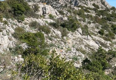
El Linas, montée sur colline avec vue sur Montner et Força Réal.
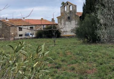
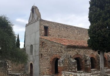
Descente dans correc, sentier balisé, route, puis suivre Chapelle St  Laurent.
Arrive route, à gauche, carrière à dr jusqu'à sommet colline , descente par chapelle.

Hoogteprofiel

Foto's

Plaatsbepaling

Land:
France
Regio :
Occitanië
Departement/Provincie :
Pyrénées-Orientales
Gemeente :
Estagel
Locatie:
Unknown
Vertrek:(Dec)
Vertrek:(UTM)
475496 ; 4735746 (31T) N.

Wandeltochten in de omgeving

Tocht Stappen Tautavel - Tautavel chemin des bacs - Photo
Stappen
jcmartin

Stappen

Gemakkelijk
(3)
Tautavel, Occitanië, Pyrénées-Orientales, France
9,5 km | 12,4 km-effort
2h 30min
Ja
Tocht Stappen Latour-de-France - Latour de France 08/12/2021 - Photo
Stappen
andre66

Stappen

Medium
Latour-de-France, Occitanië, Pyrénées-Orientales, France
12,4 km | 16,2 km-effort
3h 12min
Ja
Tocht Stappen Tautavel - TAUTAVEL la Tour del Far A/R - Photo
Stappen
MarieFrancoise

Stappen

Medium
Tautavel, Occitanië, Pyrénées-Orientales, France
6,3 km | 11,4 km-effort
3h 55min
Ja
Tocht Stappen Tautavel - Tautavel -Torre del Far - Photo
Stappen
robertperello

Stappen

Medium
(1)
Tautavel, Occitanië, Pyrénées-Orientales, France
9,5 km | 15,4 km-effort
3h 1min
Ja
Tocht Stappen Tautavel - La torre del far Tautavel - Photo
Stappen
ombrabella

Stappen

Tautavel, Occitanië, Pyrénées-Orientales, France
9,6 km | 15,6 km-effort
3h 11min
Ja
Tocht Stappen Estagel - 20201216 Estagel - Calce  - Photo
Stappen
ThonyM

Stappen

Medium
Estagel, Occitanië, Pyrénées-Orientales, France
15,8 km | 22 km-effort
3h 36min
Ja
Tocht Stappen Tautavel - tautavel - Photo
Stappen
fournieralain

Stappen

Heel gemakkelijk
Tautavel, Occitanië, Pyrénées-Orientales, France
14,6 km | 19,4 km-effort
8h 5min
Ja
Tocht Stappen Latour-de-France - 66 LATOUR-DE-FRANCE, visite du village, massif de Tourèze et vallée de l'Agly - Photo
Stappen
Phidel66

Stappen

Medium
Latour-de-France, Occitanië, Pyrénées-Orientales, France
8,3 km | 11 km-effort
1h 47min
Ja
Tocht Stappen Tautavel - mas amiel - Photo
Stappen
Fildesir

Stappen

Heel gemakkelijk
Tautavel, Occitanië, Pyrénées-Orientales, France
19 km | 24 km-effort
6h 15min
Ja


Sluiten
Mijn abonnementen