Tocht Mountainbike Bouxières-aux-Dames - entre chien et loups - Photo
 chinois54220
chinois54220

Gebruiker

© OpenStreetMap contributors
Lengte
Lengte
36 km
Max. hoogte
Max. hoogte
404 m
Positief hoogteverschil
706 m
Km-Effort
Km-Effort  
45 km
Min. hoogte
Min. hoogte
195 m
Negatief hoogteverschil
710 m
Boucle
Boucle
Ja
Datum van aanmaak :
2014-12-10 00:00:00.0
Laatste wijziging :
2014-12-10 00:00:00.0

(0 Bericht)

Mountainbike
Mountainbike
--
Moeilijkheid : Onbekend

Scan deze QR-code om de tocht te openen in de SityTrail-applicatie

Gratisgps-wandelapplicatie

Logo SityTrail SityTrail

IGN / Geografische instituten

SityTrail uit de App Store downloaden SityTrail uit Google Play downloaden

Logo SityTrail SityTrail World

De wereld gaat voor u open

SityTrail uit de App Store downloaden SityTrail uit Google Play downloaden SityTrail op Huawei AppGallery downloaden

Over ons

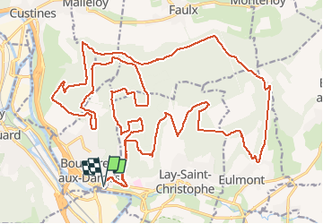
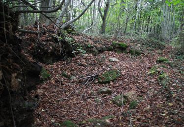
Tocht Mountainbike van 36 km beschikbaar op Grand Est, Meurthe-et-Moselle, Bouxières-aux-Dames. Deze tocht wordt voorgesteld door chinois54220.

Hoogteprofiel

Plaatsbepaling

Land:
France
Regio :
Grand Est
Departement/Provincie :
Meurthe-et-Moselle
Gemeente :
Bouxières-aux-Dames
Locatie:
Unknown
Vertrek:(Dec)
Vertrek:(UTM)
291963 ; 5403264 (32U) N.

Wandeltochten in de omgeving

Tocht Te voet Champigneulles - Circuit du Val Saint-Barthélémy - Photo
Te voet
PRO

Te voet

Gemakkelijk
Champigneulles, Grand Est, Meurthe-et-Moselle, France
7 km | 8,6 km-effort
1h 57min
Ja
Tocht Te voet Champigneulles - Circuit du Noirval - Photo
Te voet
PRO

Te voet

Gemakkelijk
Champigneulles, Grand Est, Meurthe-et-Moselle, France
11,1 km | 13,5 km-effort
3h 4min
Ja
Tocht Fietstoerisme Frouard - 4ème rando vélo Frouard - Lagarde 62 km - Photo
Fietstoerisme
GUIDE
jeanmarcMasson

Fietstoerisme

Zeer moeilijk
Frouard, Grand Est, Meurthe-et-Moselle, France
62 km | 67 km-effort
4h 32min
Neen
Tocht Te voet Lay-Saint-Christophe - Circuit L - Photo
Te voet
PRO

Te voet

Gemakkelijk
Lay-Saint-Christophe, Grand Est, Meurthe-et-Moselle, France
14,7 km | 18,5 km-effort
4h 11min
Ja
Tocht Te voet Champigneulles - Circuit G : Circuit principal - Photo
Te voet
PRO

Te voet

Gemakkelijk
Champigneulles, Grand Est, Meurthe-et-Moselle, France
8,4 km | 11,1 km-effort
2h 31min
Neen
Tocht Te voet Champigneulles - Circuit de Bellefontaine - général ouest - Photo
Te voet
PRO

Te voet

Gemakkelijk
Champigneulles, Grand Est, Meurthe-et-Moselle, France
6,1 km | 8 km-effort
1h 48min
Neen
Tocht Te voet Champigneulles - Circuit du Vallum de la Fourasse - Photo
Te voet
PRO

Te voet

Gemakkelijk
Champigneulles, Grand Est, Meurthe-et-Moselle, France
3,3 km | 4,9 km-effort
1h 6min
Ja
Tocht Te voet Bouxières-aux-Dames - Circuit moyenne ceinture - Photo
Te voet
PRO

Te voet

Gemakkelijk
Bouxières-aux-Dames, Grand Est, Meurthe-et-Moselle, France
3,8 km | 5,3 km-effort
1h 12min
Ja
Tocht Stappen Eulmont - 2020-12-11_18h42m13_Eulmont_La tour du Crany_10kms - Photo
Stappen
Marin B

Stappen

Moeilijk
(1)
Eulmont, Grand Est, Meurthe-et-Moselle, France
9,6 km | 12,6 km-effort
2h 51min
Ja


Sluiten
Mijn abonnementen