Tocht Stappen Laroque-des-Albères - LAROQUE- SOREDE- ST_ANDRE- ST_GENIS - Photo

LAROQUE- SOREDE- ST_ANDRE- ST_GENIS

 jeff66
jeff66

Gebruiker

© OpenStreetMap contributors
Lengte
Lengte
21 km
Max. hoogte
Max. hoogte
218 m
Positief hoogteverschil
237 m
Km-Effort
Km-Effort  
24 km
Min. hoogte
Min. hoogte
26 m
Negatief hoogteverschil
238 m
Boucle
Boucle
Ja
Datum van aanmaak :
2015-04-08 00:00:00.0
Laatste wijziging :
2015-04-08 00:00:00.0

(1 Bericht)

Stappen
Stappen
3h19
Moeilijkheid : Gemakkelijk

Scan deze QR-code om de tocht te openen in de SityTrail-applicatie

Gratisgps-wandelapplicatie

Logo SityTrail SityTrail

IGN / Geografische instituten

SityTrail uit de App Store downloaden SityTrail uit Google Play downloaden

Logo SityTrail SityTrail World

De wereld gaat voor u open

SityTrail uit de App Store downloaden SityTrail uit Google Play downloaden SityTrail op Huawei AppGallery downloaden

Over ons

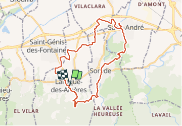
Tocht Stappen van 21 km beschikbaar op Occitanië, Pyrénées-Orientales, Laroque-des-Albères. Deze tocht wordt voorgesteld door jeff66.

Beschrijving

LAROQUE - SOREDE par la route des mas et RIVIERE de sorede- saint André par la MILLOSSA - ST génis par la plaine

Hoogteprofiel

POI's

POI Laroque-des-Albères - Point 1 - Photo
jeff66
LAROQUE-DES-ALBÈRES 
POI Laroque-des-Albères - Point 2 - Photo
jeff66
LAROQUE-DES-ALBÈRES 
POI Laroque-des-Albères - Point 3 - Photo
jeff66
LAROQUE-DES-ALBÈRES 
POI Laroque-des-Albères - Point 4 - Photo
jeff66
LAROQUE-DES-ALBÈRES 
POI Laroque-des-Albères - Point 5 - Photo
jeff66
LAROQUE-DES-ALBÈRES 
POI Laroque-des-Albères - Point 6 - Photo
jeff66
LAROQUE-DES-ALBÈRES 
POI Laroque-des-Albères - Point 7 - Photo
jeff66
LAROQUE-DES-ALBÈRES 
POI Laroque-des-Albères - Point 8 - Photo
jeff66
LAROQUE-DES-ALBÈRES 
POI Laroque-des-Albères - Point 9 - Photo
jeff66
LAROQUE-DES-ALBÈRES 
POI Sorède - Point 10 - Photo
jeff66
SORÈDE 
POI Sorède - Point 11 - Photo
jeff66
SORÈDE 
POI Sorède - Point 12 - Photo
jeff66
SORÈDE 
POI Sorède - Point 13 - Photo
jeff66
SORÈDE 
POI Sorède - Point 14 - Photo
jeff66
SORÈDE 
POI Sorède - Point 15 - Photo
jeff66
SORÈDE 
POI Saint-André - Point 16 - Photo
jeff66
SAINT-ANDRÉ 
POI Saint-André - Point 17 - Photo
jeff66
SAINT-ANDRÉ 
POI Saint-André - Point 18 - Photo
jeff66
SAINT-ANDRÉ 
POI Saint-André - Point 19 - Photo
jeff66
SAINT-ANDRÉ 
POI Saint-André - Point 20 - Photo
jeff66
SAINT-ANDRÉ 
POI Saint-André - Point 21 - Photo
jeff66
SAINT-ANDRÉ 
POI Saint-André - Point 22 - Photo
jeff66
SAINT-ANDRÉ 
POI Sorède - Point 23 - Photo
jeff66
SORÈDE 
POI Laroque-des-Albères - Point 24 - Photo
jeff66
LAROQUE-DES-ALBÈRES 
POI Laroque-des-Albères - Point 25 - Photo
jeff66
LAROQUE-DES-ALBÈRES 
POI Laroque-des-Albères - Point 26 - Photo
jeff66
LAROQUE-DES-ALBÈRES 
POI Laroque-des-Albères - Point 27 - Photo
jeff66
LAROQUE-DES-ALBÈRES 

Plaatsbepaling

Land:
France
Regio :
Occitanië
Departement/Provincie :
Pyrénées-Orientales
Gemeente :
Laroque-des-Albères
Locatie:
Unknown
Vertrek:(Dec)
Vertrek:(UTM)
494735 ; 4707812 (31T) N.

Opmerkingen

Gelieve in te loggen om een commentaar of een beoordeling achter te laten


Wandeltochten in de omgeving

Tocht Stappen Laroque-des-Albères - 66 LAROQUE DES ALBERES (maison) SOREDE, par pistes DFCI AL12 et 19, mas del Ca et mas Manere, Itin.16  - Photo
Stappen
jeff66

Stappen

Medium
(1)
Laroque-des-Albères, Occitanië, Pyrénées-Orientales, France
11,2 km | 15,3 km-effort
2h 5min
Ja
Tocht Stappen Laroque-des-Albères - 66 SOREDE, LAROQUE DES ALBERES, chemins des Mas - Photo
Stappen
jeff66

Stappen

Medium
(1)
Laroque-des-Albères, Occitanië, Pyrénées-Orientales, France
7 km | 8,9 km-effort
1h 22min
Ja
Tocht Stappen Saint-André - 66 SAINT-ANDRE - SOREDE - chapelle Saint Ferreol de la Pava  - Photo
Stappen
jeff66

Stappen

Medium
(1)
Saint-André, Occitanië, Pyrénées-Orientales, France
14,2 km | 16,9 km-effort
2h 25min
Ja
Tocht Stappen L'Albère - SAINT-JEAN-D'ALBERE 66 - PUIG  de Sant Christau par le coll de Sant Joan  - Photo
Stappen
jeff66

Stappen

Moeilijk
(1)
L'Albère, Occitanië, Pyrénées-Orientales, France
10,1 km | 17 km-effort
2h 46min
Ja
Tocht Stappen Montesquieu-des-Albères - MONTESQUIEU-DES-ALBERES 66 - Les Agouillous - les chemins de l'eau dans les Albères - Photo
Stappen
jeff66

Stappen

Medium
(1)
Montesquieu-des-Albères, Occitanië, Pyrénées-Orientales, France
12,7 km | 13,9 km-effort
2h 16min
Ja
Tocht Stappen Palau-del-Vidre - PALAU-DEL-VIDRE 66 - Boucle de Villeclare - promenade dans les vergers et cultures maraîchères  - Photo
Stappen
jeff66

Stappen

Gemakkelijk
(2)
Palau-del-Vidre, Occitanië, Pyrénées-Orientales, France
7,5 km | 7,9 km-effort
1h 16min
Ja
Tocht Stappen Sorède - Utrera Font Miracles T - Photo
Stappen
force

Stappen

Medium
(1)
Sorède, Occitanië, Pyrénées-Orientales, France
10,7 km | 17,6 km-effort
3h 50min
Ja
Tocht Stappen Sorède - 577. 11km sorede roc des medes  - Photo
Stappen
Erius

Stappen

Medium
(1)
Sorède, Occitanië, Pyrénées-Orientales, France
10,5 km | 18,2 km-effort
3h 42min
Ja
Tocht Stappen Laroque-des-Albères - Col-Ullat Pic-aureille_Terrain - Photo
Stappen
force

Stappen

Medium
(1)
Laroque-des-Albères, Occitanië, Pyrénées-Orientales, France
11,2 km | 23 km-effort
4h 47min
Ja


Sluiten
Mijn abonnementen