Tocht Stappen Banyuls-dels-Aspres - 66 LE BOULOU - plans, pla et hameau de NIDOLÈRES, noeud autoroutier ferroviaire  - Photo

66 LE BOULOU - plans, pla et hameau de NIDOLÈRES, noeud autoroutier ferroviaire

 jeff66
jeff66

Gebruiker

© OpenStreetMap contributors
Lengte
Lengte
7,7 km
Max. hoogte
Max. hoogte
119 m
Positief hoogteverschil
76 m
Km-Effort
Km-Effort  
8,7 km
Min. hoogte
Min. hoogte
54 m
Negatief hoogteverschil
76 m
Boucle
Boucle
Ja
Datum van aanmaak :
2015-09-21 00:00:00.0
Laatste wijziging :
2015-09-21 00:00:00.0

(0 Bericht)

Stappen
Stappen
1h21
Moeilijkheid : Gemakkelijk

Scan deze QR-code om de tocht te openen in de SityTrail-applicatie

Gratisgps-wandelapplicatie

Logo SityTrail SityTrail

IGN / Geografische instituten

SityTrail uit de App Store downloaden SityTrail uit Google Play downloaden

Logo SityTrail SityTrail World

De wereld gaat voor u open

SityTrail uit de App Store downloaden SityTrail uit Google Play downloaden SityTrail op Huawei AppGallery downloaden

Over ons

Tocht Stappen van 7,7 km beschikbaar op Occitanië, Pyrénées-Orientales, Banyuls-dels-Aspres. Deze tocht wordt voorgesteld door jeff66.

Beschrijving

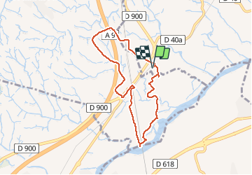
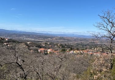
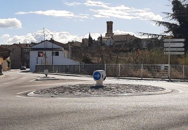
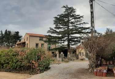
66 LE BOULOU - plans de NIDOLÈRES - poste électrique - auberge - vue sur les Albères - hameau de NIDOLÈRES, rue St éloi, place st Étienne, mas ste Lucie, rue du moulin, mon. Ste Lucie - le Tech - ouvrage d'art et piste le long de la ligne TGV - pla de NIDOLÈRES - noeud auto-ferroviaire, passage sous la ligne TGV, traverser la ligne SNCF classique, la longer à côté de la RN9, jusqu'au rond point - El mas d'en Gaspar - mas Roca - mas Maillols - pont au dessus de l'A9 - mas d'en Costaseca - mas de la Palla - la Creu Verda

Hoogteprofiel

Foto's

Plaatsbepaling

Land:
France
Regio :
Occitanië
Departement/Provincie :
Pyrénées-Orientales
Gemeente :
Banyuls-dels-Aspres
Locatie:
Unknown
Vertrek:(Dec)
Vertrek:(UTM)
488393 ; 4710839 (31T) N.

Wandeltochten in de omgeving

Tocht Stappen Montesquieu-des-Albères - MONTESQUIEU-DES-ALBERES 66 - Les Agouillous - les chemins de l'eau dans les Albères - Photo
Stappen
jeff66

Stappen

Medium
(1)
Montesquieu-des-Albères, Occitanië, Pyrénées-Orientales, France
12,7 km | 13,9 km-effort
2h 16min
Ja
Tocht Stappen Le Boulou - LES THERMES DU BOULOU - 66 - Albera viva - PUIG de l'Estella - Photo
Stappen
jeff66

Stappen

Medium
(2)
Le Boulou, Occitanië, Pyrénées-Orientales, France
7,3 km | 11,4 km-effort
1h 32min
Ja
Tocht Stappen Saint-Jean-Lasseille - ST-JEAN-LASSEILLE 66 - terroirs des Aspres - Photo
Stappen
jeff66

Stappen

Gemakkelijk
(1)
Saint-Jean-Lasseille, Occitanië, Pyrénées-Orientales, France
12,2 km | 14,3 km-effort
2h 6min
Ja
Tocht Stappen Brouilla - RP66 BROUILLA - BANYULS DELS ASPRES - par les bords de Tech et Vignobles - le 31.03.2017 - Photo
Stappen
jeff66

Stappen

Gemakkelijk
(3)
Brouilla, Occitanië, Pyrénées-Orientales, France
7,5 km | 8,3 km-effort
1h 26min
Ja
Tocht Stappen Le Boulou - Le Boulou, chapelle saint Phillipe, mas d'en Conte - Photo
Stappen
nandaf

Stappen

Medium
(1)
Le Boulou, Occitanië, Pyrénées-Orientales, France
5,2 km | 7,6 km-effort
1h 43min
Ja
Tocht Stappen Montesquieu-des-Albères - Montesquieu des Albères - Photo
Stappen
nandaf

Stappen

Medium
(1)
Montesquieu-des-Albères, Occitanië, Pyrénées-Orientales, France
7,4 km | 10,9 km-effort
2h 27min
Ja
Tocht Stappen Passa - prieuré du monastir del camp - Photo
Stappen
66Gribouille83

Stappen

Medium
Passa, Occitanië, Pyrénées-Orientales, France
9,7 km | 10,8 km-effort
3h 20min
Ja
Tocht Stappen Passa - monastur del camp different - Photo
Stappen
66Gribouille83

Stappen

Moeilijk
Passa, Occitanië, Pyrénées-Orientales, France
11,1 km | 12,4 km-effort
2h 50min
Ja
Tocht Stappen Le Boulou - 20130219 boucle au Boulou - Photo
Stappen
ThonyM

Stappen

Medium
Le Boulou, Occitanië, Pyrénées-Orientales, France
10,4 km | 16,4 km-effort
3h 0min
Ja


Sluiten
Mijn abonnementen