


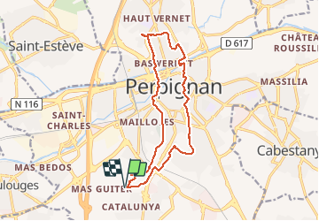

6,7 km | 7,5 km-effort


Gebruiker


Gratisgps-wandelapplicatie
 SityTrail
IGN / Geografische instituten
SityTrail World
De wereld gaat voor u open
Tocht Stappen van 16,2 km beschikbaar op Occitanië, Pyrénées-Orientales, Perpignan. Deze tocht wordt voorgesteld door jeff66.
RP66 PERPIGNAN centre commercial porte d'Espagne - Bas Vernet - le 22.03.2017

Stappen

Stappen

Stappen
Stappen

Mountainbike
Quad

Stappen

Stappen

Stappen