Valtournenche, Unknown: Best trails, routes and walks

Valtournenche: Discover the best trails: 24 hiking trails. All these trails, routes and outdoor activities are available in our SityTrail applications for smartphones and tablets.
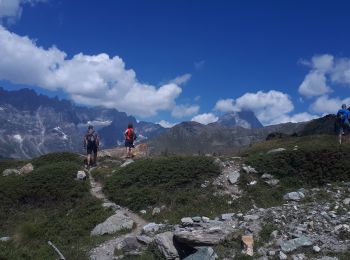

The best trails (28)

Trail On foot Valtournenche - Alta Via n. 1 della Valle d'Aosta - Tappa 10 - Photo
On foot 16.122
Km
PRO

On foot

Difficult
Valtournenche, Aosta Valley, Unknown, Italy
16.1 km | 33 km-effort
7h 24min
1353 m
876 m
No
SityTrail - itinéraires balisés pédestres

• Rifugio Barmasse - Rifugio Cunéy Alte Vie Website: http://www.lovevda.it/it/banca-dati/7/alte-vie/valle-d-aosta/rif...

Trail On foot Valtournenche - Alta Via n. 1 della Valle d'Aosta - Tappa 9 - Photo
On foot 4.504
Km
PRO

On foot

Easy
Valtournenche, Aosta Valley, Unknown, Italy
4.5 km | 11.2 km-effort
2h 32min
658 m
21 m
No
SityTrail - itinéraires balisés pédestres

• Valtournenche - Rifugio Barmasse Alte Vie Website: http://www.lovevda.it/it/banca-dati/7/alte-vie/valle-d-aosta/val...

Trail On foot Valtournenche - (SI F17) Valtournenche - Rifugio Grand Tournalin - Photo
On foot 8.747
Km
PRO

On foot

Medium
Valtournenche, Aosta Valley, Unknown, Italy
8.7 km | 23 km-effort
5h 13min
1319 m
310 m
No
SityTrail - itinéraires balisés pédestres

• Sentiero Italia CAI 2019

Trail On foot Valtournenche - (SI F16) Rifugio Barmasse - Valtournenche - Photo
On foot 4.562
Km
PRO

On foot

Easy
Valtournenche, Aosta Valley, Unknown, Italy
4.6 km | 7 km-effort
1h 34min
20 m
658 m
No
SityTrail - itinéraires balisés pédestres

• Sentiero Italia CAI 2019

Trail On foot Valtournenche - Sentier Jean Antoine Carrel - 30 km - E/EE - Photo
On foot 27.111
Km
PRO

On foot

Very difficult
Valtournenche, Aosta Valley, Unknown, Italy
27 km | 45 km-effort
10h 15min
1354 m
1347 m
Yes
SityTrail - itinéraires balisés pédestres

• Trail created by Comune di Valtournenche.

Trail On foot Valtournenche - Itinerario 11 Rifugio Bobba Cervinia - Photo
On foot 4.002
Km
PRO

On foot

Easy
Valtournenche, Aosta Valley, Unknown, Italy
4 km | 11.5 km-effort
2h 37min
748 m
11 m
No
SityTrail - itinéraires balisés pédestres

• Trail created by Comune di Valtournenche.

Trail On foot Valtournenche - Itinerario 17 Breuil/Cervinia-Bec Pio Merlo - Photo
On foot 4.541
Km
PRO

On foot

Easy
Valtournenche, Aosta Valley, Unknown, Italy
4.5 km | 10.7 km-effort
2h 25min
609 m
9 m
No
SityTrail - itinéraires balisés pédestres

• Trail created by Comune di Valtournenche.

Trail On foot Valtournenche - Itinerario n. 2 Moulin Cortina - Photo
On foot 3.716
Km
PRO

On foot

Easy
Valtournenche, Aosta Valley, Unknown, Italy
3.7 km | 11.4 km-effort
2h 34min
762 m
5 m
No
SityTrail - itinéraires balisés pédestres

• Trail created by Comune di Valtournenche.

Trail Walking Valtournenche - Cheneil a Crepin via lago Doz - Photo
Walking 17.836
Km

Walking

Difficult
Valtournenche, Aosta Valley, Unknown, Italy
17.8 km | 31 km-effort
5h 12min
982 m
955 m
No
David Toussaint

Trail On foot Valtournenche - IT-4 - Photo
On foot 3.974
Km
PRO

On foot

Easy
Valtournenche, Aosta Valley, Unknown, Italy
4 km | 6.5 km-effort
1h 29min
10 m
742 m
No
SityTrail - itinéraires balisés pédestres

• Trail created by Comune di Valtournenche.

Trail On foot Valtournenche - Itinerario 35 Cignana - Colle Valcornera - Photo
On foot 5.889
Km
PRO

On foot

Easy
Valtournenche, Aosta Valley, Unknown, Italy
5.9 km | 15.2 km-effort
3h 27min
931 m
11 m
No
SityTrail - itinéraires balisés pédestres

• Trail created by Comune di Valtournenche.

Trail On foot Valtournenche - Itinerario 23 Colle della Roisette - Photo
On foot 3.101
Km
PRO

On foot

Easy
Valtournenche, Aosta Valley, Unknown, Italy
3.1 km | 4.9 km-effort
1h 7min
6 m
535 m
No
SityTrail - itinéraires balisés pédestres

• Trail created by Comune di Valtournenche.

Trail Other activity Valtournenche - bdr03_Matterhorn_Gondo - Photo
Other activity 76.183
Km
GUIDE+

Other activity

Very easy
Valtournenche, Aosta Valley, Unknown, Italy
76 km | 192 km-effort
Unknown
7797 m
11353 m
No
My Switzerland

Trail Other activity Valtournenche - xxx02_Trient_Matterhorn - Photo
Other activity 95.11
Km
GUIDE+

Other activity

Very easy
Valtournenche, Aosta Valley, Unknown, Italy
95 km | 262 km-effort
62h 11min
11733 m
15014 m
No
My Switzerland

Trail Walking Valtournenche - de Crepin à Chamois puis Cheneil - Photo
Walking 12.506
Km

Walking

Medium
Valtournenche, Aosta Valley, Unknown, Italy
12.5 km | 24 km-effort
5h 40min
953 m
514 m
No
David Toussaint

Trail Walking Valtournenche - Lago Doz - Photo
Walking 8.497
Km

Walking

Easy
Valtournenche, Aosta Valley, Unknown, Italy
8.5 km | 12.4 km-effort
2h 55min
292 m
293 m
Yes
David Toussaint

Trail Walking Valtournenche - de Pereres a Crepin - Photo
Walking 13.605
Km

Walking

Medium
Valtournenche, Aosta Valley, Unknown, Italy
13.6 km | 25 km-effort
6h 40min
765 m
1005 m
No
David Toussaint

Trail Walking Valtournenche - crepin, val dAoste 7a - Photo
Walking 5.231
Km

Walking

Medium
Valtournenche, Aosta Valley, Unknown, Italy
5.2 km | 8 km-effort
2h 0min
205 m
206 m
Yes
David Toussaint

Trail Walking Valtournenche - Val d ayas  Breuil   Cervinia par col supériorité sine blanca   - Photo
Walking 10.497
Km

Walking

Very easy
Valtournenche, Aosta Valley, Unknown, Italy
10.5 km | 17.9 km-effort
5h 52min
303 m
1307 m
No
chris13370

• 1350 m négatif

Trail Walking Valtournenche - Becca d'Aran - Sentier Grand Tournalin - Photo
Walking 10.376
Km

Walking

Easy
Valtournenche, Aosta Valley, Unknown, Italy
10.4 km | 20 km-effort
4h 4min
721 m
715 m
Yes
Brusa

• Vue l'impossibilité de traverser le torrent pour monter au Bec d'Aran - plan B sur le sentier du Grand Tournalin

20 trails displayed on 28

FREE GPS app for hiking

Logo SityTrail SityTrail

IGN / Geographical institutes

Download SityTrail from the App Store Download SityTrail from Google Play

Logo SityTrail SityTrail World

The world is yours!

Download SityTrail from the App Store Download SityTrail from Google Play Download SityTrail on Huawei AppGallery

Activities

Close
My subscriptions