Col de la Madeleine Cheval Noir

ARPF
User
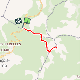

Length
9.5 km

Max alt
2798 m

Uphill gradient
838 m
Km-Effort
21 km

Min alt
1990 m

Downhill gradient
838 m
Boucle
Yes
Creation date :
2019-01-15 13:00:40.489
Updated on :
2019-01-15 13:00:40.489
5h30
Difficulty : Difficult

FREE GPS app for hiking
 SityTrail
IGN / Geographical institutes
SityTrail Plus
The world is yours!
About
Trail Walking of 9.5 km to be discovered at Auvergne-Rhône-Alpes, Savoy, La Léchère. This trail is proposed by ARPF.
Description
superbe point de vue en 360 degré au Cheval Noir
Positioning
Country:
France
Region :
Auvergne-Rhône-Alpes
Department/Province :
Savoy
Municipality :
La Léchère
Location:
Celliers
Start:(Dec)
Start:(UTM)
294748 ; 5034699 (32T) N.
Comments