


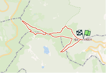
Gaschney-Schiessroth-Col de Falimont-Le Hohneck-Schaeferthal et retour

patrickbeyrath
User

Length
8.1 km

Max alt
1355 m

Uphill gradient
475 m
Km-Effort
14.5 km

Min alt
991 m

Downhill gradient
477 m
Boucle
Yes
Creation date :
2018-10-13 05:51:46.429
Updated on :
2018-10-13 05:51:46.429
2h55
Difficulty : Medium

FREE GPS app for hiking
 SityTrail
IGN / Geographical institutes
SityTrail Plus
The world is yours!
About
Trail Walking of 8.1 km to be discovered at Grand Est, Haut-Rhin, Stosswihr. This trail is proposed by patrickbeyrath.
Positioning
Country:
France
Region :
Grand Est
Department/Province :
Haut-Rhin
Municipality :
Stosswihr
Location:
Unknown
Start:(Dec)
Start:(UTM)
354393 ; 5321949 (32U) N.
Comments