Trail Walking Monthodon - Monthodon - et Le Sentier - 26.7km 230m 6h00 - 2018 07 15 - public - Photo

Monthodon - et Le Sentier - 26.7km 230m 6h00 - 2018 07 15 - public

 Orcal37
Orcal37

User

© OpenStreetMap contributors
Length
Length
27 km
Max alt
Max alt
168 m
Uphill gradient
Uphill gradient
228 m
Km-Effort
Km-Effort  
30 km
Min alt
Min alt
124 m
Downhill gradient
Downhill gradient
231 m
Boucle
Boucle
Yes
Creation date :
2019-01-15 13:04:49.432
Updated on :
2019-08-18 09:23:37.927

(0 Reviews)

Walking
Walking
5h45
Difficulty : Easy

Scan this QR Code to open this trail in the SityTrail application

FREE GPS app for hiking

Logo SityTrail SityTrail

IGN / Geographical institutes

Download SityTrail from the App Store Download SityTrail from Google Play

Logo SityTrail SityTrail World

The world is yours!

Download SityTrail from the App Store Download SityTrail from Google Play Download SityTrail on Huawei AppGallery

About

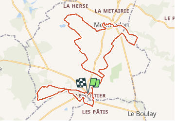
Trail Walking of 27 km to be discovered at Centre-Loire Valley, Indre-et-Loire, Monthodon. This trail is proposed by Orcal37.

Description

Monthodon - et Le Sentier - 26.7km 230m 6h00 - 2018 07 15 - public

Elevation profile

Photos

Positioning

Country:
France
Region :
Centre-Loire Valley
Department/Province :
Indre-et-Loire
Municipality :
Monthodon
Location:
Unknown
Start:(UTM)
336149 ; 5275994 (31T) N.

Trails nearby

Trail Walking Saint-Laurent-en-Gâtines - Saint-Laurent-en-Gâtines - variante du PR Chemin de Chenusson - 10.2km 90m 2h25 - 2023 07 30 - Photo
Walking
Orcal37

Walking

Easy
Saint-Laurent-en-Gâtines, Centre-Loire Valley, Indre-et-Loire, France
10.3 km | 11.5 km-effort
2h 25min
Yes
Trail Walking  - Monthodon - l'Aître Adam - 18.1km 140m 4h00 (35mn) - 2023 07 26 - Photo
Walking
Orcal37

Walking

Easy
(1)
, Centre-Loire Valley, Indre-et-Loire, France
18.2 km | 20 km-effort
4h 0min
Yes
Trail Walking Saint-Laurent-en-Gâtines - Saint-Laurent-en-Gatines - Photo
Walking
guydu41

Walking

Difficult
Saint-Laurent-en-Gâtines, Centre-Loire Valley, Indre-et-Loire, France
13.1 km | 14.9 km-effort
3h 23min
Yes
Trail Walking Monthodon - Monthodon Le Sentier - Photo
Walking
guydu41

Walking

Medium
Monthodon, Centre-Loire Valley, Indre-et-Loire, France
8.5 km | 9.5 km-effort
2h 9min
Yes
Trail Walking Le Boulay - le Boulay - circuits Le pain sec et le Boulay avec variante le Sentier - 21.4km 180m 5h15 - 2022 05 05 - Photo
Walking
Orcal37

Walking

Easy
Le Boulay, Centre-Loire Valley, Indre-et-Loire, France
21 km | 24 km-effort
5h 15min
Yes
Trail Walking Saint-Laurent-en-Gâtines - Saint-Laurent-en-Gâtines - Circuit jaune avec variante le Sentier - 18.7km 120m 4h30 - 2022 05 01 - Photo
Walking
Orcal37

Walking

Easy
Saint-Laurent-en-Gâtines, Centre-Loire Valley, Indre-et-Loire, France
18.7 km | 20 km-effort
4h 30min
Yes
Trail Walking Le Boulay - le boulay sentier du pain  sec - Photo
Walking
dporcher

Walking

Very easy
Le Boulay, Centre-Loire Valley, Indre-et-Loire, France
9.3 km | 10.2 km-effort
2h 8min
No
Trail Walking Saint-Laurent-en-Gâtines - saint laurent en gatine - Photo
Walking
dporcher

Walking

Easy
Saint-Laurent-en-Gâtines, Centre-Loire Valley, Indre-et-Loire, France
13.9 km | 14.9 km-effort
2h 59min
Yes
Trail Walking Saint-Laurent-en-Gâtines - Saint Laurent en Gâtine 23, 5km - Photo
Walking
dporcher

Walking

Easy
Saint-Laurent-en-Gâtines, Centre-Loire Valley, Indre-et-Loire, France
23 km | 27 km-effort
4h 28min
Yes


Close
My subscriptions