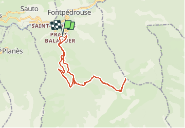
7.2 km | 15.3 km-effort
Prats-Balagers - le Gallinas
ThonyM
User
Length
17.3 km
Max alt
2612 m
Uphill gradient
1353 m
Km-Effort
35 km
Min alt
1315 m
Downhill gradient
1348 m
Boucle
Yes
Creation date :
2019-01-15 13:14:53.386
Updated on :
2019-01-15 13:14:53.386
6h15
Difficulty : Difficult
FREE GPS app for hiking
About
Trail Walking of 17.3 km to be discovered at Occitania, Pyrénées-Orientales, Fontpédrouse. This trail is proposed by ThonyM.
Description
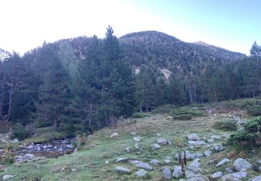
Retour par la piste (une tendinite dans l'équipe. Plus abordable que le Redoun. Derniers mètres escarpés
Positioning
Country:
France
Region :
Occitania
Department/Province :
Pyrénées-Orientales
Municipality :
Fontpédrouse
Location:
Unknown
Start:(Dec)
Start:(UTM)
432070 ; 4705521 (31T) N.
Comments
Trails nearby
boucle des gorges de Caranca
Walking
Medium
(2)
Thuès-Entre-Valls,
Occitania,
Pyrénées-Orientales,
France
3h 1min
Yes
Gorges de la garanca
Walking
Very easy
(1)
Thuès-Entre-Valls,
Occitania,
Pyrénées-Orientales,
France
6.7 km | 13.1 km-effort
3h 39min
No
Tour du Cucurucull
Walking
Medium
(1)
Fontpédrouse,
Occitania,
Pyrénées-Orientales,
France
9.3 km | 18.5 km-effort
3h 24min
Yes
étang de Planès
Walking
Medium
(2)
Planès,
Occitania,
Pyrénées-Orientales,
France
10.8 km | 19.6 km-effort
3h 54min
No
fontpérouse sentier des canaux et sources chaudes naturelles_T
Walking
Medium
(1)
Fontpédrouse,
Occitania,
Pyrénées-Orientales,
France
13.7 km | 25 km-effort
5h 9min
Yes
bains de St Thomas
Walking
Medium
(1)
Saint-Pierre-dels-Forcats,
Occitania,
Pyrénées-Orientales,
France
8.6 km | 12.2 km-effort
2h 42min
No
llagonne - Calvet
Walking
Medium
(2)
La Llagonne,
Occitania,
Pyrénées-Orientales,
France
11.2 km | 14.2 km-effort
3h 0min
No
Gorges de Carança
Walking
Medium
(2)
Thuès-Entre-Valls,
Occitania,
Pyrénées-Orientales,
France
13.6 km | 30 km-effort
3h 43min
Yes
2022 TRANSPYRÉNÉENNE : refuge du Ras de la Carança
Walking
Difficult
Fontpédrouse,
Occitania,
Pyrénées-Orientales,
France
17.2 km | 31 km-effort
4h 36min
No