Trail Mountain bike Saint-Martin-la-Garenne - La Garennoise 2005-47km - Photo
 tracegps
tracegps

User

© OpenStreetMap contributors
Length
Length
47 km
Max alt
Max alt
212 m
Uphill gradient
Uphill gradient
960 m
Km-Effort
Km-Effort  
60 km
Min alt
Min alt
31 m
Downhill gradient
Downhill gradient
960 m
Boucle
Boucle
Yes
Creation date :
2014-12-10 00:00:00.0
Updated on :
2014-12-10 00:00:00.0

(2 Reviews)

Mountain bike
Mountain bike
3h30
Difficulty : Difficult

Scan this QR Code to open this trail in the SityTrail application

FREE GPS app for hiking

Logo SityTrail SityTrail

IGN / Geographical institutes

Download SityTrail from the App Store Download SityTrail from Google Play

Logo SityTrail SityTrail World

The world is yours!

Download SityTrail from the App Store Download SityTrail from Google Play Download SityTrail on Huawei AppGallery

About

Trail Mountain bike of 47 km to be discovered at Ile-de-France, Yvelines, Saint-Martin-la-Garenne. This trail is proposed by tracegps.

Description

L'édition 2005 des 47 km

Elevation profile

Photos

Positioning

Country:
France
Region :
Ile-de-France
Department/Province :
Yvelines
Municipality :
Saint-Martin-la-Garenne
Location:
Unknown
Start:(UTM)
403728 ; 5432660 (31U) N.

Comments

Please log in to post a review or rate the element


Super application je m'en sert en randonnée VTT le GPS est très précis avec en plus les cartes IGN de plus on peut créer nos parcours sur le site enfin que du bon pour moi la meilleur comparée à garmin par exemple


Super application je m'en sert en randonnée VTT le GPS est très précis avec en plus les cartes IGN de plus on peut créer nos parcours sur le site enfin que du bon pour moi la meilleur comparée à garmin par exemple


Trails nearby

Trail Walking Limay - De Limay à Dennemont - Photo
Walking
tracegps

Walking

Medium
(1)
Limay, Ile-de-France, Yvelines, France
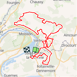
10.9 km | 14.7 km-effort
1h 30min
Yes
Trail On foot Vétheuil - Vétheuil Bords de Seine et coteaux - Photo
On foot
Fky78

On foot

Easy
(1)
Vétheuil, Ile-de-France, Val-d'Oise, France
9.5 km | 11.8 km-effort
2h 38min
Yes
Trail Walking Vétheuil - La Roche Guyon depuis Vétheuil - Photo
Walking
louisgef

Walking

Medium
(1)
Vétheuil, Ile-de-France, Val-d'Oise, France
20 km | 27 km-effort
6h 0min
Yes
Trail Walking La Roche-Guyon - La Roche-Guyon boucle - Photo
Walking
vincentph

Walking

Easy
(1)
La Roche-Guyon, Ile-de-France, Val-d'Oise, France
15.5 km | 19.5 km-effort
4h 15min
Yes
Trail Walking Vétheuil - Vetheuil - la petite suisse - Photo
Walking
marcel.F

Walking

Easy
(1)
Vétheuil, Ile-de-France, Val-d'Oise, France
15.5 km | 20 km-effort
4h 20min
Yes
Trail Walking Guernes - guernes port de l'ilon - Photo
Walking
mictar78

Walking

Very easy
(2)
Guernes, Ile-de-France, Yvelines, France
12.5 km | 13.5 km-effort
2h 48min
Yes
Trail Walking Saint-Martin-la-Garenne - 160117 - Saint-Martin la Garenne - Photo
Walking
domelisa78

Walking

Easy
(1)
Saint-Martin-la-Garenne, Ile-de-France, Yvelines, France
14.2 km | 15.7 km-effort
3h 27min
Yes
Trail Nordic walking Mantes-la-Jolie -  ile l Aumône 10/06/2016 - Photo
Nordic walking
microb

Nordic walking

Easy
Mantes-la-Jolie, Ile-de-France, Yvelines, France
8.3 km | 9.1 km-effort
2h 20min
Yes
Trail Walking Vétheuil - randonnée vetheuil - Photo
Walking
olipim78

Walking

Medium
(2)
Vétheuil, Ile-de-France, Val-d'Oise, France
10.4 km | 13.3 km-effort
2h 54min
Yes


Close
My subscriptions