Trail Mountain bike Plaine - Rando des Brimbelles 01 - Photo

Rando des Brimbelles 01

 tracegps
tracegps

User

© OpenStreetMap contributors
Length
Length
45 km
Max alt
Max alt
908 m
Uphill gradient
Uphill gradient
1347 m
Km-Effort
Km-Effort  
63 km
Min alt
Min alt
342 m
Downhill gradient
Downhill gradient
1347 m
Boucle
Boucle
Yes
Creation date :
2014-12-10 00:00:00.0
Updated on :
2014-12-10 00:00:00.0

(0 Reviews)

Mountain bike
Mountain bike
4h00
Difficulty : Very difficult

Scan this QR Code to open this trail in the SityTrail application

FREE GPS app for hiking

Logo SityTrail SityTrail

IGN / Geographical institutes

Download SityTrail from the App Store Download SityTrail from Google Play

Logo SityTrail SityTrail World

The world is yours!

Download SityTrail from the App Store Download SityTrail from Google Play Download SityTrail on Huawei AppGallery

About

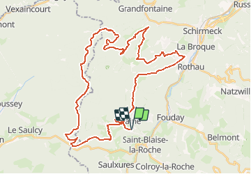
Trail Mountain bike of 45 km to be discovered at Grand Est, Bas-Rhin, Plaine. This trail is proposed by tracegps.

Description

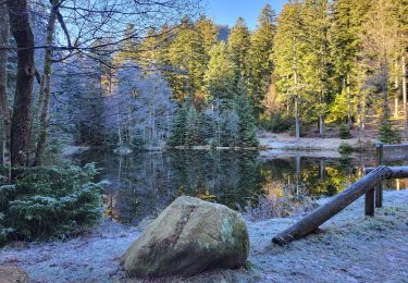
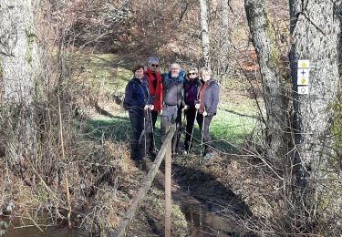
Les chemins sont souvent carrossables, excepté pour les descentes, sablonneux et dégagés d'arbres. La première difficulté technique se situe près de la M.F. à Bambois. Vous allez traverser un ruisseau et vous vous retrouverez juste derrière dans un raidillon très empierré. Ce parcours comporte deux montées principales. La première se situe après Albet et la seconde par la R.F. de l'Aiguille. Elles ne présentent pas de difficultés si ce n'est qu'elles sont longues et nécessitent du souffle. Attention aux quelques descentes qui jalonnent de parcours. La suite est ICI Source A.S.T.T. Plaine

Elevation profile

Photos

Positioning

Country:
France
Region :
Grand Est
Department/Province :
Bas-Rhin
Municipality :
Plaine
Location:
Unknown
Start:(UTM)
363041 ; 5363916 (32U) N.

Trails nearby

Trail Walking La Broque - 2013-05-18 Marche Ruines de Salm - Photo
Walking
GUIDE
holtzv

Walking

Very easy
(2)
La Broque, Grand Est, Bas-Rhin, France
6.9 km | 10.6 km-effort
2h 38min
Yes
Trail Walking Plaine - Champenay - Photo
Walking
VacheKiri67

Walking

Medium
(1)
Plaine, Grand Est, Bas-Rhin, France
17.9 km | 27 km-effort
6h 30min
Yes
Trail Walking La Broque - 2023-05-13 Marche Sentier des Passeurs Salm - Photo
Walking
GUIDE
holtzv

Walking

Medium
La Broque, Grand Est, Bas-Rhin, France
25 km | 36 km-effort
7h 49min
Yes
Trail Walking Solbach - Rando Solbach  - Photo
Walking
enciloti

Walking

Medium
(1)
Solbach, Grand Est, Bas-Rhin, France
4.6 km | 6.6 km-effort
1h 29min
Yes
Trail Walking Fouday - HOTEL JULIEN v - Photo
Walking
valeureux

Walking

Easy
(1)
Fouday, Grand Est, Bas-Rhin, France
7.8 km | 10.5 km-effort
2h 20min
Yes
Trail Walking La Broque - Etang du Coucou - Château de Salm - Chatte pendue - Haute Loge - Chapelle Bipierre - Photo
Walking
Bart2015

Walking

Very difficult
La Broque, Grand Est, Bas-Rhin, France
19.9 km | 29 km-effort
6h 32min
Yes
Trail Walking Plaine - Fouday - Photo
Walking
PhilWas

Walking

Difficult
Plaine, Grand Est, Bas-Rhin, France
10.4 km | 14.4 km-effort
2h 45min
Yes
Trail Walking Plaine - Plaine et la Chatte Pendue - Photo
Walking
VacheKiri67

Walking

Medium
Plaine, Grand Est, Bas-Rhin, France
13.5 km | 21 km-effort
4h 10min
Yes
Trail Walking Ranrupt - Ranrupt autour du Climont - Photo
Walking
LUTZMarc

Walking

Medium
Ranrupt, Grand Est, Bas-Rhin, France
17.1 km | 25 km-effort
4h 30min
Yes


Close
My subscriptions