Trail Walking Cergy - CERGY > VALMONDOIS 23 KM - Photo

CERGY > VALMONDOIS 23 KM

 gemau77
gemau77

User

© OpenStreetMap contributors
Length
Length
22 km
Max alt
Max alt
116 m
Uphill gradient
Uphill gradient
174 m
Km-Effort
Km-Effort  
25 km
Min alt
Min alt
18 m
Downhill gradient
Downhill gradient
263 m
Boucle
Boucle
No
Creation date :
2019-03-18 15:01:51.338
Updated on :
2023-11-30 08:02:31.487

(0 Reviews)

Walking
Walking
5h42
Difficulty : Very difficult

Scan this QR Code to open this trail in the SityTrail application

FREE GPS app for hiking

Logo SityTrail SityTrail

IGN / Geographical institutes

Download SityTrail from the App Store Download SityTrail from Google Play

Logo SityTrail SityTrail World

The world is yours!

Download SityTrail from the App Store Download SityTrail from Google Play Download SityTrail on Huawei AppGallery

About

Trail Walking of 22 km to be discovered at Ile-de-France, Val-d'Oise, Cergy. This trail is proposed by gemau77.

Description

26e partie du grand tour de Paris

https://www.openrunner.com/r/9346633

Elevation profile

Points of interest

Point of interest Pontoise - Pontoise - Photo
gemau77
PONTOISE 
Point of interest Auvers-sur-Oise - CHAPONVAL  - Photo
gemau77
AUVERS-SUR-OISE 
Point of interest Auvers-sur-Oise - AUVERS SUR OISE - Photo
gemau77
AUVERS-SUR-OISE 

Positioning

Country:
France
Region :
Ile-de-France
Department/Province :
Val-d'Oise
Municipality :
Cergy
Location:
Unknown
Start:(UTM)
427801 ; 5433310 (31U) N.

Trails nearby

Trail Walking Jouy-le-Moutier - GRP CV-IDF 2023 - Photo
Walking
clalaur

Walking

Difficult
(1)
Jouy-le-Moutier, Ile-de-France, Val-d'Oise, France
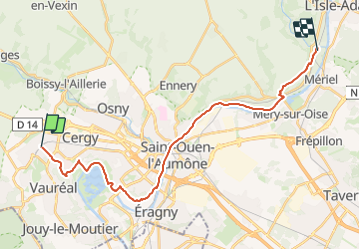
15.6 km | 18 km-effort
4h 4min
No
Trail Running Cergy - Les Bords de l'Oise et la Passerelle de l'Axe Majeur - Port Cergy - Photo
Running
tracegps

Running

Easy
(1)
Cergy, Ile-de-France, Val-d'Oise, France
5.2 km | 5.8 km-effort
30min
Yes
Trail On foot Cergy - LES BALADES DE L’ÉTÉ # 9 / DE L’AXE MAJEUR À PORT CERGY - Photo
On foot
Vadim

On foot

Very easy
(1)
Cergy, Ile-de-France, Val-d'Oise, France
6 km | 7.4 km-effort
1h 45min
Yes
Trail On foot Cergy - Le Fil d'Ariane - Photo
On foot
PRO

On foot

Easy
Cergy, Ile-de-France, Val-d'Oise, France
3.2 km | 3.7 km-effort
50min
No
Trail Walking Neuville-sur-Oise - base losir cergy  - Photo
Walking
bertrandgeffroy

Walking

Medium
(1)
Neuville-sur-Oise, Ile-de-France, Val-d'Oise, France
22 km | 26 km-effort
5h 35min
No
Trail Walking Boissy-l'Aillerie - La chaussée Jules César - Photo
Walking
ppeul

Walking

Very easy
(2)
Boissy-l'Aillerie, Ile-de-France, Val-d'Oise, France
10.9 km | 13.9 km-effort
Unknown
Yes
Trail Walking Osny - Osny chateau chateau Groussy - Photo
Walking
avdem

Walking

Easy
Osny, Ile-de-France, Val-d'Oise, France
11.1 km | 12.9 km-effort
3h 3min
Yes
Trail Walking Puiseux-Pontoise - chaussée Jules cesar - Photo
Walking
unirega

Walking

Medium
Puiseux-Pontoise, Ile-de-France, Val-d'Oise, France
6.8 km | 8.6 km-effort
1h 51min
Yes
Trail Walking Boissy-l'Aillerie - Bois l'Artillerie. Boucle de Courmonbois - Photo
Walking
avdem

Walking

Difficult
(1)
Boissy-l'Aillerie, Ile-de-France, Val-d'Oise, France
11.5 km | 13.3 km-effort
2h 42min
Yes


Close
My subscriptions