Trail Walking Gavarnie-Gèdre - Pic de la Munia - Photo
 tracegps
tracegps

User

© OpenStreetMap contributors
Length
Length
5.2 km
Max alt
Max alt
3101 m
Uphill gradient
Uphill gradient
1056 m
Km-Effort
Km-Effort  
15.9 km
Min alt
Min alt
2076 m
Downhill gradient
Downhill gradient
55 m
Boucle
Boucle
No
Creation date :
2014-12-10 00:00:00.0
Updated on :
2014-12-10 00:00:00.0

(1 Reviews)

Walking
Walking
3h00
Difficulty : Very difficult

Scan this QR Code to open this trail in the SityTrail application

FREE GPS app for hiking

Logo SityTrail SityTrail

IGN / Geographical institutes

Download SityTrail from the App Store Download SityTrail from Google Play

Logo SityTrail SityTrail World

The world is yours!

Download SityTrail from the App Store Download SityTrail from Google Play Download SityTrail on Huawei AppGallery

About

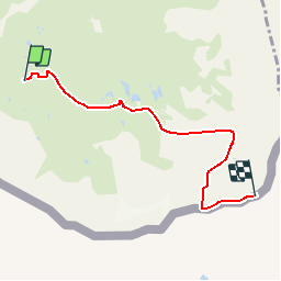
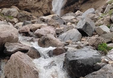
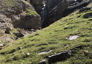
Trail Walking of 5.2 km to be discovered at Occitania, Hautespyrenees, Gavarnie-Gèdre. This trail is proposed by tracegps.

Description

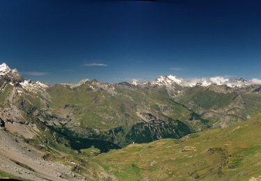
Un sommet un peu oublié où les mains sont parfois nécessaires et l’isolement toujours bien présent… Toutes les descriptions indispensables et les photos sont sur Montagne Cool

Elevation profile

Photos

Positioning

Country:
France
Region :
Occitania
Department/Province :
Hautespyrenees
Municipality :
Gavarnie-Gèdre
Location:
Gèdre
Start:(UTM)
262201 ; 4734724 (31T) N.

Comments

Please log in to post a review or rate the element


Trails nearby

Trail Walking Gavarnie-Gèdre - Le Pimené par la vallée d'Estaubé  - Gèbre - Photo
Walking
tracegps

Walking

Difficult
(1)
Gavarnie-Gèdre, Occitania, Hautespyrenees, France
19.8 km | 35 km-effort
9h 0min
Yes
Trail Walking Gavarnie-Gèdre - jc.pambrun@yahoo.fr - Photo
Walking
sebastienPBN

Walking

Easy
(1)
Gavarnie-Gèdre, Occitania, Hautespyrenees, France
28 km | 48 km-effort
6h 19min
No
Trail Walking Gavarnie-Gèdre - PYRENNES  cirque d'Estaube   - Photo
Walking
ego

Walking

Medium
(1)
Gavarnie-Gèdre, Occitania, Hautespyrenees, France
6.1 km | 8.6 km-effort
1h 56min
No
Trail Walking Gavarnie-Gèdre - Gèdre - barrage des gloriettes - Photo
Walking
marcel.F

Walking

Easy
(1)
Gavarnie-Gèdre, Occitania, Hautespyrenees, France
6.2 km | 8.3 km-effort
1h 57min
Yes
Trail Walking Gavarnie-Gèdre - Héas- Hourquette d'Héas - Photo
Walking
pffrench

Walking

Difficult
Gavarnie-Gèdre, Occitania, Hautespyrenees, France
15.8 km | 31 km-effort
7h 7min
Yes
Trail Walking Gavarnie-Gèdre - Les Gloriettes et Cascades .  - Photo
Walking
sereton

Walking

Medium
Gavarnie-Gèdre, Occitania, Hautespyrenees, France
12.3 km | 15.5 km-effort
3h 56min
Yes
Trail Walking Gavarnie-Gèdre - Cirque d’Estaubé - Photo
Walking
jaja64

Walking

Easy
Gavarnie-Gèdre, Occitania, Hautespyrenees, France
13.5 km | 18.2 km-effort
6h 5min
Yes
Trail On foot Gavarnie-Gèdre - Cirque de Troumouse - Photo
On foot
PRO

On foot

Easy
Gavarnie-Gèdre, Occitania, Hautespyrenees, France
4.6 km | 10.5 km-effort
2h 23min
No
Trail On foot Gavarnie-Gèdre - Vers la Hourquette d'Alans par le Cirque d'Estaubé - Photo
On foot
PRO

On foot

Easy
Gavarnie-Gèdre, Occitania, Hautespyrenees, France
7.8 km | 15.8 km-effort
3h 35min
No


Close
My subscriptions