Trail Mountain bike Saint-Ferréol-Trente-Pas - Espace VTT FFC La Drome Provençale - Tour VTT du Pays  Nyonsais - Photo

Espace VTT FFC La Drome Provençale - Tour VTT du Pays Nyonsais

 tracegps
tracegps

User

© OpenStreetMap contributors
Length
Length
83 km
Max alt
Max alt
1204 m
Uphill gradient
Uphill gradient
3542 m
Km-Effort
Km-Effort  
131 km
Min alt
Min alt
260 m
Downhill gradient
Downhill gradient
3536 m
Boucle
Boucle
Yes
Creation date :
2014-12-10 00:00:00.0
Updated on :
2014-12-10 00:00:00.0

(0 Reviews)

Mountain bike
Mountain bike
8h00
Difficulty : Very difficult

Scan this QR Code to open this trail in the SityTrail application

FREE GPS app for hiking

Logo SityTrail SityTrail

IGN / Geographical institutes

Download SityTrail from the App Store Download SityTrail from Google Play

Logo SityTrail SityTrail World

The world is yours!

Download SityTrail from the App Store Download SityTrail from Google Play Download SityTrail on Huawei AppGallery

About

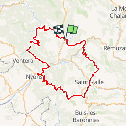
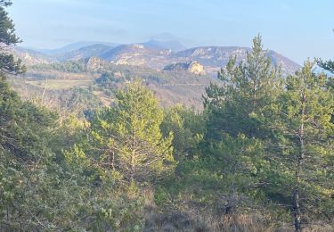
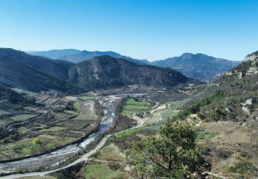
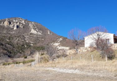
Trail Mountain bike of 83 km to be discovered at Auvergne-Rhône-Alpes, Drôme, Saint-Ferréol-Trente-Pas. This trail is proposed by tracegps.

Description

La Drôme Provençale, Auberge des Trente Pas Circuit labellisé par la Fédération Française de Cyclisme. Superbe parcours sportif qui vous fera découvrir le massif des Baronnies, « un petit coin de paradis pour le VTT de montagne » du courage, de la sueur, et de bonnes cuisses pour venir à bout des sept cols qu’il vous faudra franchir, mais quel plaisir à chaque nouveau panorama découvert au sommet. Vous pourrez choisir votre rythme, puisque cet itinéraire peut se faire en 1, 2 ou 3 étapes. Différentes solutions d’hébergement et autres services sont possibles pour organiser au mieux votre randonnée, pour cela n’hésitez pas à nous contacter. Bonne randonnée à tous.

Elevation profile

Photos

Positioning

Country:
France
Region :
Auvergne-Rhône-Alpes
Department/Province :
Drôme
Municipality :
Saint-Ferréol-Trente-Pas
Location:
Unknown
Start:(UTM)
676481 ; 4921735 (31T) N.

Trails nearby

Trail Walking Sahune - Le Rocher du Bramard - Sahune - Photo
Walking
tracegps

Walking

Medium
(2)
Sahune, Auvergne-Rhône-Alpes, Drôme, France
11.2 km | 19.6 km-effort
5h 0min
Yes
Trail Walking Saint-Ferréol-Trente-Pas - St Ferreol Trente pas - Photo
Walking
Cricounet84

Walking

Medium
(1)
Saint-Ferréol-Trente-Pas, Auvergne-Rhône-Alpes, Drôme, France
15.2 km | 26 km-effort
5h 53min
Yes
Trail Walking Sahune - rocher de Bramard - Photo
Walking
GUIDE
nadinebondoux

Walking

Medium
Sahune, Auvergne-Rhône-Alpes, Drôme, France
12.4 km | 21 km-effort
4h 35min
Yes
Trail Walking Eyroles - Eyroles - Photo
Walking
gilchan

Walking

Medium
(2)
Eyroles, Auvergne-Rhône-Alpes, Drôme, France
11 km | 17.7 km-effort
3h 42min
Yes
Trail Walking Sahune - Sahune - Photo
Walking
tracegps

Walking

Medium
(2)
Sahune, Auvergne-Rhône-Alpes, Drôme, France
7.1 km | 12.5 km-effort
2h 30min
Yes
Trail Walking Saint-Ferréol-Trente-Pas - St Ferréol-Mont Vautour 14km - Photo
Walking
GUIDE
thonyc

Walking

Difficult
Saint-Ferréol-Trente-Pas, Auvergne-Rhône-Alpes, Drôme, France
14.2 km | 26 km-effort
5h 0min
Yes
Trail Walking Condorcet - Condorcet petite boucle par le château  - Photo
Walking
aitkhedache

Walking

Easy
Condorcet, Auvergne-Rhône-Alpes, Drôme, France
7.6 km | 10.6 km-effort
3h 17min
Yes
Trail Walking Sahune - Asptt  SAHUNE VILLEPERDRIX - Photo
Walking
TOULAUDIN

Walking

Difficult
Sahune, Auvergne-Rhône-Alpes, Drôme, France
16.5 km | 27 km-effort
6h 29min
Yes
Trail Walking Valouse - mielandre  - Photo
Walking
andrechauvin

Walking

Very difficult
Valouse, Auvergne-Rhône-Alpes, Drôme, France
11.3 km | 23 km-effort
6h 34min
Yes


Close
My subscriptions