Trail Mountain bike Saint-Anthème - Espace VTT FFC de la Vallée de l'Ance - Circuit n° 2 - Photo

Espace VTT FFC de la Vallée de l'Ance - Circuit n° 2

 tracegps
tracegps

User

© OpenStreetMap contributors
Length
Length
22 km
Max alt
Max alt
1244 m
Uphill gradient
Uphill gradient
551 m
Km-Effort
Km-Effort  
29 km
Min alt
Min alt
892 m
Downhill gradient
Downhill gradient
553 m
Boucle
Boucle
Yes
Creation date :
2014-12-10 00:00:00.0
Updated on :
2014-12-10 00:00:00.0

(1 Reviews)

Mountain bike
Mountain bike
2h15
Difficulty : Difficult

Scan this QR Code to open this trail in the SityTrail application

FREE GPS app for hiking

Logo SityTrail SityTrail

IGN / Geographical institutes

Download SityTrail from the App Store Download SityTrail from Google Play

Logo SityTrail SityTrail World

The world is yours!

Download SityTrail from the App Store Download SityTrail from Google Play Download SityTrail on Huawei AppGallery

About

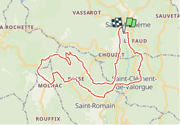
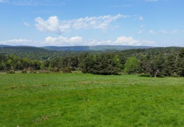
Trail Mountain bike of 22 km to be discovered at Auvergne-Rhône-Alpes, Puy-de-Dôme, Saint-Anthème. This trail is proposed by tracegps.

Description

Espace VTT FFC de la Vallée de l’Ance Circuit labellisé par la Fédération Française de Cyclisme. Après un départ sympa, la suite comporte une partie technique et difficile qui vous conduit au cœur d’une forêt caractéristique de la région. La descente dur St Clément de Valorgue est vraiment du gâteau. Quant au retour sur St Anthème par la vallée de l’Ance, c’est la cerise qui va avec.

Elevation profile

Photos

Positioning

Country:
France
Region :
Auvergne-Rhône-Alpes
Department/Province :
Puy-de-Dôme
Municipality :
Saint-Anthème
Location:
Unknown
Start:(UTM)
571451 ; 5041525 (31T) N.

Comments

Please log in to post a review or rate the element


très belle balade pas trop difficile et variée


Trails nearby

Trail On foot Grandrif - Sur la piste du chevreuil - Photo
On foot
PRO

On foot

Easy
Grandrif, Auvergne-Rhône-Alpes, Puy-de-Dôme, France
4.7 km | 6.2 km-effort
1h 24min
Yes
Trail On foot Saint-Anthème - Beauvoir - Photo
On foot
PRO

On foot

Easy
Saint-Anthème, Auvergne-Rhône-Alpes, Puy-de-Dôme, France
7.4 km | 11.7 km-effort
2h 39min
Yes
Trail On foot Saint-Anthème - Les Prats-de-la-Chaux - Photo
On foot
PRO

On foot

Easy
Saint-Anthème, Auvergne-Rhône-Alpes, Puy-de-Dôme, France
13.3 km | 19.1 km-effort
4h 19min
No
Trail Walking Saint-Romain - Chaulmes  - Photo
Walking
jepea

Walking

Easy
Saint-Romain, Auvergne-Rhône-Alpes, Puy-de-Dôme, France
9.2 km | 14.8 km-effort
1h 56min
No
Trail Road bike Saint-Anthème - Ça pique  - Photo
Road bike
pierrebmw84

Road bike

Difficult
Saint-Anthème, Auvergne-Rhône-Alpes, Puy-de-Dôme, France
40 km | 52 km-effort
2h 38min
Yes
Trail On foot Saint-Romain - Le bonheur est dans le bois - Photo
On foot
PRO

On foot

Easy
Saint-Romain, Auvergne-Rhône-Alpes, Puy-de-Dôme, France
4.2 km | 6.4 km-effort
1h 26min
No
Trail Walking Gumières - col H Mort - Photo
Walking
gannet1

Walking

Easy
Gumières, Auvergne-Rhône-Alpes, Loire, France
8.4 km | 11.3 km-effort
2h 3min
Yes
Trail Walking Grandrif - chougoirand - Photo
Walking
viverols

Walking

Easy
Grandrif, Auvergne-Rhône-Alpes, Puy-de-Dôme, France
7.3 km | 10.3 km-effort
2h 16min
Yes
Trail Walking Gumières - Boucle du col de Baracuchet - Photo
Walking
dudu42

Walking

Easy
Gumières, Auvergne-Rhône-Alpes, Loire, France
14.3 km | 18.2 km-effort
3h 11min
Yes


Close
My subscriptions