Trail Mountain bike Rosans - La descente du facteur en VTT - Photo

La descente du facteur en VTT

 tracegps
tracegps

User

© OpenStreetMap contributors
Length
Length
7.2 km
Max alt
Max alt
1104 m
Uphill gradient
Uphill gradient
70 m
Km-Effort
Km-Effort  
9.5 km
Min alt
Min alt
663 m
Downhill gradient
Downhill gradient
478 m
Boucle
Boucle
No
Creation date :
2014-12-10 00:00:00.0
Updated on :
2014-12-10 00:00:00.0

(0 Reviews)

Mountain bike
Mountain bike
19m
Difficulty : Difficult

Scan this QR Code to open this trail in the SityTrail application

FREE GPS app for hiking

Logo SityTrail SityTrail

IGN / Geographical institutes

Download SityTrail from the App Store Download SityTrail from Google Play

Logo SityTrail SityTrail World

The world is yours!

Download SityTrail from the App Store Download SityTrail from Google Play Download SityTrail on Huawei AppGallery

About

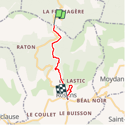
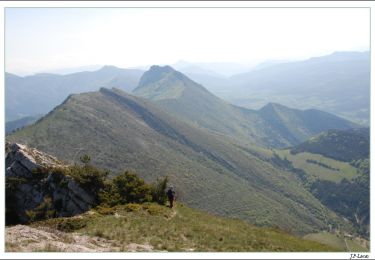
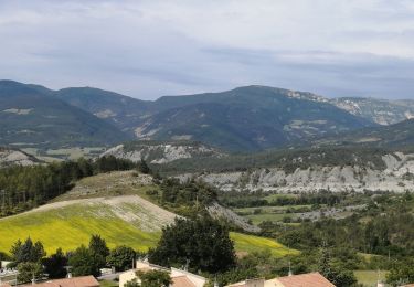
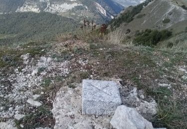
Trail Mountain bike of 7.2 km to be discovered at Provence-Alpes-Côte d'Azur, Hautes-Alpes, Rosans. This trail is proposed by tracegps.

Description

Jolie descente au départ du col de Pomerol ( de la Fromagère ?) Il existe également la descente du ratons au départ du même col.

Elevation profile

Positioning

Country:
France
Region :
Provence-Alpes-Côte d'Azur
Department/Province :
Hautes-Alpes
Municipality :
Rosans
Location:
Unknown
Start:(UTM)
696001 ; 4922183 (31T) N.

Trails nearby

Trail Walking Rosans - 7km Fourchat AR par chemin du facteur (partie) - Photo
Walking
Pierre Jongen

Walking

Difficult
Rosans, Provence-Alpes-Côte d'Azur, Hautes-Alpes, France
6.8 km | 13.2 km-effort
3h 30min
Yes
Trail Walking Rosans - Le Fourchat - Photo
Walking
Marco05

Walking

Difficult
Rosans, Provence-Alpes-Côte d'Azur, Hautes-Alpes, France
12.1 km | 24 km-effort
5h 21min
Yes
Trail Road bike La Charce - 75km VC La Charce Montmorin Serres Carabès Valdrôme La Chance - Photo
Road bike
Pierre Jongen

Road bike

Very difficult
(1)
La Charce, Auvergne-Rhône-Alpes, Drôme, France
75 km | 97 km-effort
6h 2min
Yes
Trail Walking Rosans - Montagne de Raton au départ du col de Pommerol ou de la Fromagère - Photo
Walking
jean-marie.parachini

Walking

Medium
Rosans, Provence-Alpes-Côte d'Azur, Hautes-Alpes, France
6.8 km | 12.1 km-effort
7h 29min
Yes
Trail Walking Rosans - POMMEROL - LA MONTAGNE DE RATON - Photo
Walking
jean-marie.parachini

Walking

Difficult
Rosans, Provence-Alpes-Côte d'Azur, Hautes-Alpes, France
7.1 km | 12.4 km-effort
6h 49min
Yes
Trail Mountain bike Rosans - HA J2 long - Photo
Mountain bike
thierryd

Mountain bike

Very easy
(2)
Rosans, Provence-Alpes-Côte d'Azur, Hautes-Alpes, France
48 km | 65 km-effort
4h 12min
No
Trail Walking Pommerol -  Col de La Fromagère - Le Fourchat - Photo
Walking
tracegps

Walking

Difficult
Pommerol, Auvergne-Rhône-Alpes, Drôme, France
4.5 km | 10.6 km-effort
2h 30min
Yes
Trail Walking Rosans - le mont Fourchat - Photo
Walking
Vero7684

Walking

Medium
Rosans, Provence-Alpes-Côte d'Azur, Hautes-Alpes, France
11.9 km | 24 km-effort
4h 36min
Yes
Trail Walking Rosans - Le Fourchat par le col de Pommerol - Photo
Walking
nadd73

Walking

Medium
Rosans, Provence-Alpes-Côte d'Azur, Hautes-Alpes, France
2.6 km | 7.3 km-effort
57min
No


Close
My subscriptions