Trail Walking Plan-de-Cuques - Autour du Pic du Taoumé - Photo
 tracegps
tracegps

User

© OpenStreetMap contributors
Length
Length
38 km
Max alt
Max alt
687 m
Uphill gradient
Uphill gradient
1063 m
Km-Effort
Km-Effort  
53 km
Min alt
Min alt
131 m
Downhill gradient
Downhill gradient
1063 m
Boucle
Boucle
Yes
Creation date :
2014-12-10 00:00:00.0
Updated on :
2014-12-10 00:00:00.0

(0 Reviews)

Walking
Walking
8h00
Difficulty : Difficult

Scan this QR Code to open this trail in the SityTrail application

FREE GPS app for hiking

Logo SityTrail SityTrail

IGN / Geographical institutes

Download SityTrail from the App Store Download SityTrail from Google Play

Logo SityTrail SityTrail World

The world is yours!

Download SityTrail from the App Store Download SityTrail from Google Play Download SityTrail on Huawei AppGallery

About

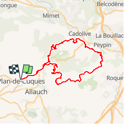
Trail Walking of 38 km to be discovered at Provence-Alpes-Côte d'Azur, Bouches-du-Rhône, Plan-de-Cuques. This trail is proposed by tracegps.

Description

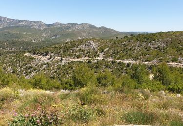
Ce parcours de 39 KM (1000M ) permet de découvrir le massif du Garlaban en passant à côté de la grotte du gros hibou et de Baume Sourne (massif raconté par Pagnol). Ce parcours aux portes de Marseille offre une vue à 360°: d'un côté Marseille et les calanques, puis la Ste Baume, la Sainte Victoire. La dernière descente se fait dans le massif de l'Etoile par un vallon très agréable et épargné par les gros incendies de ces dernières années.

Elevation profile

Photos

Positioning

Country:
France
Region :
Provence-Alpes-Côte d'Azur
Department/Province :
Bouches-du-Rhône
Municipality :
Plan-de-Cuques
Location:
Unknown
Start:(UTM)
699589 ; 4802354 (31T) N.

Trails nearby

Trail Mountain bike Allauch - les antennes du garlaban à modifier - Photo
Mountain bike
GUIDE
harydh

Mountain bike

Medium
Allauch, Provence-Alpes-Côte d'Azur, Bouches-du-Rhône, France
19.3 km | 28 km-effort
2h 8min
Yes
Trail Mountain bike Allauch - les antennes du garlaban - Photo
Mountain bike
GUIDE
harydh

Mountain bike

Medium
Allauch, Provence-Alpes-Côte d'Azur, Bouches-du-Rhône, France
19.3 km | 28 km-effort
2h 8min
Yes
Trail Other activity Marseille - Garlaban - Photo
Other activity
JosephRigolet

Other activity

Very easy
(1)
Marseille, Provence-Alpes-Côte d'Azur, Bouches-du-Rhône, France
15.8 km | 25 km-effort
6h 35min
Yes
Trail Walking Allauch - Pic du Taoumé - Photo
Walking
GUIDE
amiral13

Walking

Easy
Allauch, Provence-Alpes-Côte d'Azur, Bouches-du-Rhône, France
9.2 km | 15.2 km-effort
5h 5min
Yes
Trail Walking Marseille - Etoile - Photo
Walking
Spinnaker

Walking

Very easy
(1)
Marseille, Provence-Alpes-Côte d'Azur, Bouches-du-Rhône, France
10.7 km | 16.2 km-effort
2h 10min
Yes
Trail Mountain bike Marseille - 2013 05 04 l étoile - Photo
Mountain bike
lboubis

Mountain bike

Medium
(2)
Marseille, Provence-Alpes-Côte d'Azur, Bouches-du-Rhône, France
25 km | 36 km-effort
2h 19min
Yes
Trail Walking Marseille - La Grande Etoile - Photo
Walking
GUIDE
lhomme.ph

Walking

Medium
Marseille, Provence-Alpes-Côte d'Azur, Bouches-du-Rhône, France
15.4 km | 23 km-effort
4h 48min
Yes
Trail Walking Allauch - allauch amandiers - Photo
Walking
lhags

Walking

Medium
(1)
Allauch, Provence-Alpes-Côte d'Azur, Bouches-du-Rhône, France
12.6 km | 19.5 km-effort
3h 37min
Yes
Trail Walking Marseille - Carla an - Photo
Walking
GUIDE
Roger Philippe Wallez

Walking

Very difficult
Marseille, Provence-Alpes-Côte d'Azur, Bouches-du-Rhône, France
20 km | 31 km-effort
5h 54min
No


Close
My subscriptions